PMM Science Banner

Science


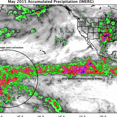
Water is fundamental to life on Earth, affecting the behavior of the weather, climate, energy and ecological systems as water moves through the Earth’s water cycle as vapor, liquid and ice. Precipitation, a key component of the water cycle, is difficult to measure since rain and snow vary greatly in both space and time.

Obtaining reliable ground-based measurements of rain and snow often presents a formidable challenge due to large gaps between reliable instruments over land and, particularly, over the oceans. From the vantage point of space, satellites provide more frequent and accurate observations and measurements of rain and snow around the globe. This allows key insights into when, where and how much it rains or snows globally, supplying vital information to unravel the complex roles water plays in Earth systems.

In order to gain further insights into the relationships between the components of the Earth’s water cycle, we need to know not only how much rain falls at the surface but also the distribution of rain, snow, and other forms of precipitation within the atmosphere above the surface. This allows us to characterize precipitation processes that are vital to understanding the links and the transfer of energy (heat) between the Earth’s surface and atmosphere.

NASA’s Global Precipitation Measurement Mission (GPM) provide advanced information on rain and snow characteristics and detailed three-dimensional knowledge of precipitation structure within the atmosphere, which help scientists study and understand Earth's water cycle, weather and climate.

Related Articles
GPM Sees Larsen-C Ice Shelf Separation
Click here to download the video (.mp4) On July 12, 2017, a giant iceberg broke off Antarctica and a variety of satellites have been used to study it ever since. The Global Precipitation Measurement (GPM) Microwave Imager (GMI) instrument can see the ribbon of relatively warm water and ice that separates the newly formed iceberg from the its parent mass of ice, the Larsen C ice shelf. While the iceberg is separated from the parent iceshelf by only a few kilometers, the GMI instrument is sensitive enough to detect the variation in temperature between this relatively warm gap and the colder ice...
Atmospheric River Slams California
After more than four years of drought, Californians may wonder where the current rain is coming from. Using satellites, NASA scientists have a unique view of the sources of precipitation, and how it reaches the western United States. Rain is often carried by narrow tendrils of moisture called atmospheric rivers that occur all over the world, shown here in white. The atmospheric rivers that affect the western United States are known as the Pineapple Express because they transport water vapor from as far south as Hawaii to California. When the moisture reaches land, it is forced up over the...
Monsoons: Wet, Dry, Repeat
Credit: NASA/Goddard/Ryan Fitzgibbons This video is public domain and along with other supporting visualizations can be downloaded from the Scientific Visualization Studio The monsoon is a seasonal rain and wind pattern that occurs over South Asia (among other places). Through NASA satellites and models we can see the monsoon patterns like never before. Monsoon rains provide important reservoirs of water that sustain human activities like agriculture and supports the natural environment through replenishment of aquifers. However, too much rainfall routinely causes disasters in the region...
Measures Raindrop Sizes From Space
Not all raindrops are created equal. The size of falling raindrops depends on several factors, including where the cloud producing the drops is located on the globe and where the drops originate in the cloud. For the first time, scientists have three-dimensional snapshots of raindrops and snowflakes around the world from space, thanks to the joint NASA and Japan Aerospace Exploration Agency Global Precipitation Measurement (GPM) mission. With the new global data on raindrop and snowflake sizes this mission provides, scientists can improve rainfall estimates from satellite data and in numerical...
OLYMPEX Successfully Grabs the Rains
NASA has finished its campaign to study extreme rain, snow and winds of the Olympic National Forest. Scientists Walt Petersen of NASA Marshall and Robert Houze of the University of Washington narrate this inside look at the Olympic Mountain Experiment (OLYMPEX) field campaign. During the campaign, NASA and its partners gathered precipitation data through both ground and airborne instruments around the Olympic Peninsula in Washington State. They measured the abundance and variety of precipitation including light rain, heavy thunderstorms, and snowfall in the coastal forest. The data collected...
OLYMPEX Scientists in the Field
From November 10 through December 21, NASA and university scientists are taking to the field to study wet winter weather near Seattle, Washington. With weather radars, weather balloons, specialized ground instruments, and NASA's DC-8 flying laboratory, the science team will be verifying rain and snowfall observations made by the Global Precipitation Measurement (GPM) satellite mission on a NASA-led field campaign, The Olympic Mountain Experiment, or OLYMPEX. Rachael Kroodsma is the instrument scientist for the CoSMIR on board NASA's DC-8 airborne laboratory as part of the OLYMPEX field...
Pacific NW Campaign to Measure Rain & Snow
From Nov. 10 through Dec. 21, NASA and university scientists are taking to the field to study wet winter weather near Seattle, Washington. With weather radars, weather balloons, specialized ground instruments, and NASA's DC-8 flying laboratory, the science team will be verifying rain and snowfall observations made by the Global Precipitation Measurement (GPM) satellite mission. Credits: NASA's Goddard Space Flight Center The Pacific Northwest was chosen because of its frequent and persistent winter rain and snowfall. On average 100 to 180 inches of precipitation fall a year, making it one of...
Media are invited to go behind the scenes of a comprehensive field campaign focused on yielding new insights into global precipitation at a special event on Nov. 11, 2015.  NASA's DC-8 deploys to Iceland on a mission to study Arctic polar winds. NASA's DC-8 flying laboratory will be featured as part of a special media event on Nov. 11, 2015 focused on the Olympic Mountain Experiment (OLYMPEX), an Earth science campaign aimed at validating Global Precipitation Measurement. Credits: NASA Photo / Carla Thomas
Media are invited to go behind the scenes of a comprehensive field campaign focused on yielding new insights into global precipitation at a special event on Nov. 11, 2015. NASA's DC-8 flying laboratory will be featured as part of a special media event on Nov. 11, 2015 focused on the Olympic Mountain Experiment (OLYMPEX), an Earth science campaign aimed at validating Global Precipitation Measurement. Credits: NASA Photo / Carla Thomas Held in collaboration with the University of Washington, NASA's Olympic Mountain Experiment (OLYMPEX) is an Earth science campaign aimed at validating Global...
Global Precipitation Measurement (GPM) Is In Position to Watch Effects of 2015’s El Niño
Since late in 2014, scientists in many different disciplines (including meteorologists, climate scientists, physical and biological oceanographers, hydrologists, and geologists) have been watching a slow-to-develop El Niño even in the tropical Pacific Ocean. After teasing observers with conditions that did not quite meet El Niño criteria 1 , the event finally reached official El Niño status in March and April, and is now expected to become a powerful event lasting into the next Northern Hemisphere winter. If these conditions, typified by warm sea surface temperatures (SST) in the tropical...
How Does NASA Study Hurricanes?
Hurricanes are the most powerful weather event on Earth. NASA’s expertise in space and scientific exploration contributes to essential services provided to the American people by other federal agencies, such as hurricane weather forecasting. The National Oceanic and Atmospheric Administration and the National Hurricane Center (NHC) use a variety of tools to predict these storms’ paths. These scientists need a wealth of data to accurately forecast hurricanes. NASA satellites, computer modeling, instruments, aircraft and field missions contribute to this mix of information to give scientists a...

Hide Body

Hide Date