Soudelor

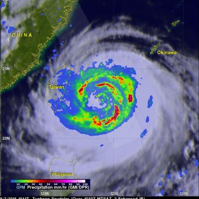
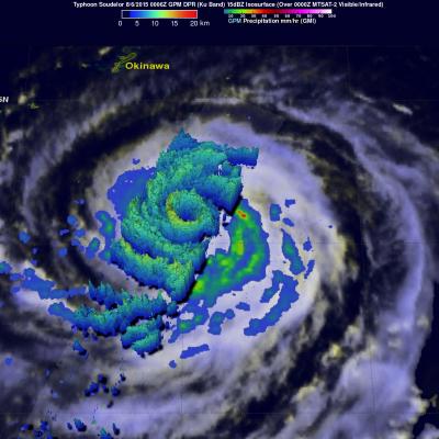
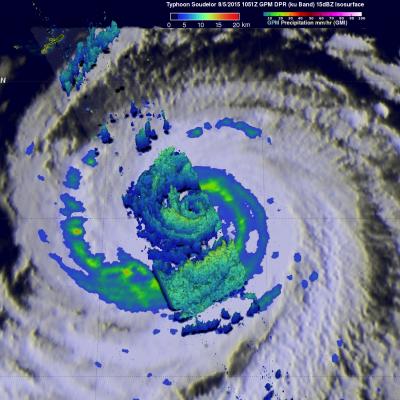
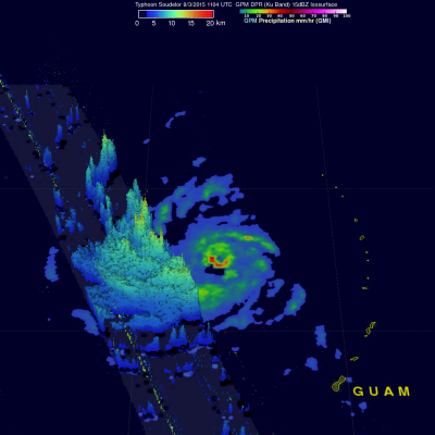
Deadly Typhoon Soudelor's Rainfall Analyzed

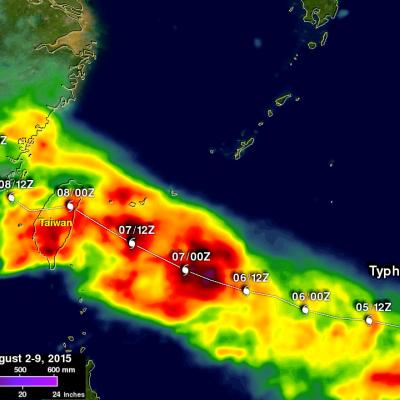
Soudelor formed in the middle of the Pacific Ocean well east of Guam on July 20, 2015. Soudelor became more powerful with peak intensity of about 155 kts (178 mph) reached on August 3, 2015 when the super typhoon was well east of Taiwan over the open waters of the Pacific Ocean. Soudelor's winds died down a little but rebounded to with over 100 kts (115 mph) before hitting Taiwan . Although Soudler was still a powerful typhoon when it hit land most deaths and destruction were caused by flooding and mudslides from heavy rainfall not from strong winds. The rugged terrain over typhoon amplified

GPM Sees Typhoon Soudelor On Taiwan's Doorstep

The GPM core observatory satellite continued to provide excellent coverage of Soudelor as the typhoon closed in on Taiwan. GPM flew directly above typhoon Soudelor's eye on August 7, 2015 at 1041Z (6:41 PM Local Time) when wind speeds were 110 kts (127 mph). Rainfall data from GPM's Microwave Imager (GMI) and Dual-Frequency Precipitation Radar (DPR) instruments revealed very heavy rainfall in spiraling bands rotating around a decaying inner eye wall. Precipitation intensity can be measured by the Dual-Frequency Precipitation Radar instrument mounted on the GPM core observatory satellite. Some

GPM Has Another Good Look At Soudelor

Typhoon Soudelor's winds had dropped to 95 kts ( 109 mph) when the GPM core observatory satellite had another excellent daytime view on August 6, 2015 at 0006 UTC. GPM's Dual-Frequency Precipitation Radar (DPR) data showed that Soudelor had heavy rainfall in an inner eye wall and also in a much larger replacement outer eye wall. The heaviest rain found by GPM was dropping at a rate of close to 70 mm (2.4 inches) per hour in a strong feeder band spiraling in on the southwestern side of the typhoon. Radar reflectivity data from GPM's Dual-Frequency Precipitation Radar (DPR) data were also used

Typhoon Soudelor Threatens Taiwan And China

Typhoon Soudelor's sustained winds were about 105 kts ( about 121 mph) when the GPM core observatory satellite flew above on August 5, 2015 at 1051 UTC. A rainfall analysis was made from data collected from GPM's Microwave Imager (GMI) and Dual-Frequency Precipitation Radar (DPR) instruments. This analysis showed that Soudelor was very large and had a well defined eye. Intense feeder bands are shown spiraling into the center. Three dimensional radar reflectivity data GPM's DPR (ku Band) were used to construct a simulated cross section through typhoon Soudelor's center. This view from the south

Super Typhoon Soudelor Threatens Taiwan And China

The GPM core observatory satellite flew almost directly over super typhoon Soudelor in the western Pacific Ocean on August 3, 2015 at 1104 UTC. At that time Super Typhoon Soudelor had winds of about 125kts (139 mph) and is predicted by the Joint Typhoon Warning Center (JTWC) to become even more powerful tomorrow while headed toward northern Taiwan. GPM's Microwave Imager (GMI) had a very good view of heavy rainfall associated with Soudelor. GMI showed that the super typhoon had rain falling at a rate of over 58 mm (2.3 inches) per hour in the southern side of Soudelor's well defined eye. Radar