Images and caption by Hal Pierce (SSAI/NASA GSFC)

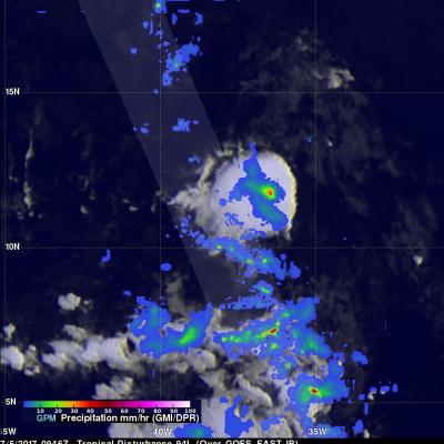
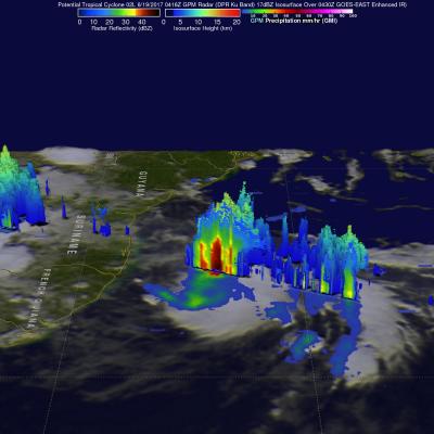
Eastern Pacific Hurricane Viewed By GPM

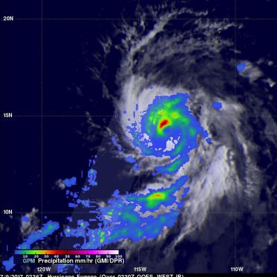
Hurricane Eugene formed on July 7, 2017 in the eastern Pacific Ocean south of the Baja Peninsula. Eugene was intensifying when the GPM core observatory satellite flew over on July 9, 2017 at 0236 UTC. Eugene reached it's peak power later that day with it's maximum sustained wind speeds reaching about 100 kts (115.0 mph). The center of GPM's track passed to the west of Eugene's eye. Data collected by GPM's Dual-Frequency Precipitation Radar (DPR) instrument showed that powerful storms in the northwestern quadrant of the hurricane were dropping rain at a rate of over 186 mm (7.3 inches) per hour

GPM Sees Possible Tropical Cyclone Forming

A low pressure system in the Atlantic Ocean west-southwest of the Cabo Verde Islands is being closely monitored for possible development into a tropical depression. The GPM core observatory satellite flew over this area on July 5, 2017 at 5:47 AM EDT (0947 UTC). GPM's Microwave Imager (GMI) and Dual-frequency Precipitation Radar (DPR) showed that heavy showers were located in this area. GPM's GMI data indicated that rain was coming down at a rate of greater than 44.2 mm (1.74 inches) per hour in one cluster of storms. GPM's radar (DPR Ku band) measured precipitation falling at rate of over

GPM Views Intensifying Tropical Storm Nanmadol

The GPM core observatory satellite flew above tropical storm NANMADOL on July 2, 2017 at 2306 UTC. The intensifying tropical storm was located just northeast of Taiwan and had maximum winds estimated at 45 kts (51.8 mph). The GPM Core Observatory carries the first space-borne Ku/Ka-band Dual-frequency Precipitation Radar (DPR) and a multi-channel GPM Microwave Imager (GMI). Rainfall within NANMADOL was derived from data collected by GPM's GMI and DPR instruments. Those data indicated that rain was falling at a rate of greater that 184 mm (7.2 inches) per in powerful storms northeast of the

NASA's IMERG Shows Cindy's Extreme Rainfall

Tropical storm Cindy was downgraded to a tropical depression after moving onshore near the Texas and Louisiana Border on Thursday June 22, 2017. Flooding was reported along the the Gulf Coast even before Cindy made landfall. The rainfall around tropical storm Cindy was asymmetrical. The majority of heavy rainfall with the tropical cyclone was located east of Cindy's center in the states along the Gulf Coast from Louisiana through the Florida Panhandle. The tropical depression continued to spread heavy rain and occasionally severe thunderstorms after it came ashore. Severe thunderstorms spawned

GPM Satellite Sees Cindy Drenching Gulf Coast

The GPM core observatory satellite passed above as tropical storm Cindy was approaching the western Louisiana coast on June 22, 2017 at 1:21 AM CDT (0621 UTC). Cindy had maximum sustained winds of about 40 kts (46 mph) at that time. A red tropical storm symbol shows Cindy's approximate location. Rainfall derived from Microwave Imager (GMI) and Dual-Frequency Precipitation Radar (DPR) measurements showed that there was very little rainfall near Cindy's center of circulation but bands of moderate to heavy showers are shown moving into the states along the Gulf Coast. GPM's Radar (DPR Ku Band)

Potential Tropical Cyclone (02L) Examined By GPM

A couple weeks after the official start of the Atlantic hurricane season the tropical Atlantic Ocean is starting to show potential tropical cyclone development. The National Hurricane Center (NHC) has indicated that potential tropical cyclone 02L, located east-southeast of Trinidad, will likely become a tropical storm within the next five days. The GPM core observatory satellite flew above 02L on June 19, 2017 at 00:16 AM EDT (0416 UTC). Data collected by Microwave Imager (GMI) and Dual-Frequency Precipitation Radar (DPR) instruments showed that the potential tropical cyclone contained some

Bangladesh's Heavy Rainfall Examined With IMERG

At least 156 people in Bangladesh were killed during the past week by landslides and floods caused by heavy rainfall. Monsoon rainfall has been especially heavy over this area that includes southeastern Bangladesh, northeastern India and western Burma (Myanmar). This disaster follows quickly on the heels of deadly cyclone Mora which hit the same area a couple weeks ago. This rainfall analysis was made at Goddard Space Flight Center using NASA's near-real time Integrated Multi-satelliE Retrievals for GPM (IMERG) data. Those IMERG data were assembled during the period from June 12-14, 2017. The

GPM Observes Tropical Storm Merbok

Tropical storm MERBOK formed in the South China Sea west of the Philippines on June 11, 2017. The GPM core observatory satellite flew above MERBOK on June 10, 2017 at 0631 UTC when the tropical storm was forming. GPM's Microwave Imager (GMI) and Dual-Frequency Precipitation Radar (DPR) showed that the future tropical storm was starting to get organized. Feeder bands were shown converging into the center of the circulation located in the South China Sea west of Luzon. GPM passed over the western side of tropical storm MERBOK again on June 12, 2017 at 0621 UTC when it's maximum sustained winds

Extreme Florida Rainfall Examined With GPM

Extremely heavy rain has recently fallen over Florida. Over 19 inches (482 mm) of rain has fallen in southeastern Florida during the past seven days. Record rainfall has been reported in Fort Lauderdale and West Palm. This extreme rainfall has led to flooding and flight cancellations. The GPM core observatory satellite flew above southern Florida on Wednesday June 7, 2017 at 6:06 AM EDT ( 1006 UTC). Data collected by GPM's Microwave Imager (GMI) and Dual-Frequency Precipitation Radar (DPR) instruments revealed the intensity of rainfall within powerful storms that were drenching southern

IMERG Shows Heavy Rainfall From Southwest India To Northeast India

In the past couple weeks rainfall has had a significant impact on Sri Lanka, southwestern India, Bangladesh and eastern India. Monsoon rainfall caused widespread flooding, devastating mudslides and displacements of many thousands of people in Sri Lanka. Over 200 people's deaths have now been attributed to this disaster. Then cyclone Mora formed in the Bay Of Bengal on May 27, 2017. Heavy rain from Mora and it's remnants moved over southeastern Bangladesh and northeastern India. Monsoon rainfall also started to move into southern India. This rainfall analysis was derived from NASA's Integrated