Tropical Cyclones

GPM's Worldwide Tour of Global Precipitation
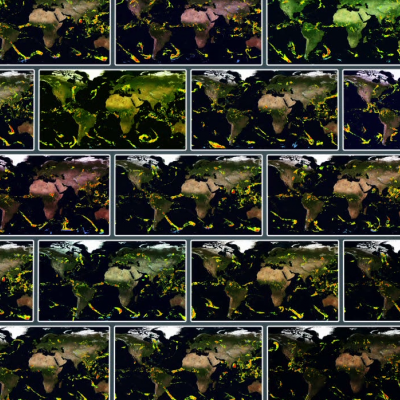
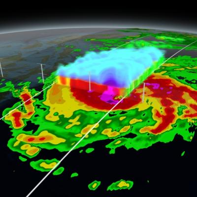
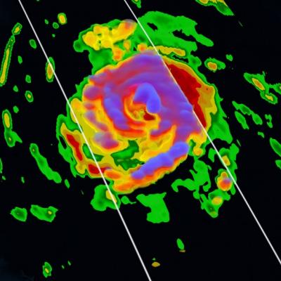
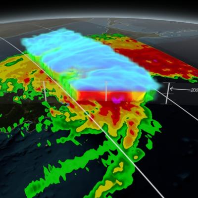
Rain, snow, hail, ice, and every mix in between make up the precipitation that touches everyone on our planet. But precipitation doesn't fall equally in all places around the world, as seen in NASA's new animation that captures every shower, snowstorm and tropical cyclone over a six-day period in August 2014. The time lapse was created from data captured by the Global Precipitation Measurement (GPM) satellite mission, now just over a year old, which scientists are using to better understand freshwater resources, natural disasters, crop health and more. Image Credit: NASA's Goddard Space Flight...
GPM Dissects Super Typhoon Hagupit
On December 5, 2014 (1032UTC) the Global Precipitation Measurement (GPM) mission's Core Observatory flew over Typhoon Hagupit as it headed towards the Philippines. A few hours later at 1500 UTC (10 a.m. EST), Super Typhoon Hagupit's maximum sustained winds were near 130 knots (149.6 mph/241 kph), down from 150 knots (172 mph/277.8 kph). Typhoon-force winds extend out 40 nautical miles (46 miles/74 km) from the center, while tropical-storm-force winds extend out to 120 miles (138 miles/222 km). Animation revealing a swath of GPM/GMI precipitation rates over Typhoon Hagupit. As the camera moves...
GPM Flies Over Hurricane Gonzalo
Download in Hi-Res from the Scientific Visualization Studio On October 16th, 2014 (1342 UTC) the Global Precipitation Measurement (GPM) mission's Core Observatory flew over Hurricane Gonzalo as it headed towards Bermuda. Hurricane Gonzalo remains a category 4 hurricane on the Saffir-Simpson Hurricane Scale, with maximum sustained winds at 130 mph. As of 12:00 UTC (8:00a.m. EDT) on Friday, October 17th, the National Hurricane Center forecast located the storm about 195 miles south southwest of Bermuda, where a hurricane warning is in effect. The GPM Core Observatory carries two instruments that...
GPM Scans Typhoon Phanfone
Animation revealing a swath of GPM/GMI precipitation rates over Typhoon Phanfone. The camera then moves down closer to the storm to reveal DPR's volumetric view of Phanphone. A slicing plane dissects the Typhoon from south to north and back again, revealing it's inner precipitation rates. Shades of blue indicate frozen precipitation (in the upper atmosphere). Shades of green to red are liquid precipitation which extend down to the ground. Download in Hi-Res from the Scientific Visualization Studio On October 6, 2014 (0215 UTC) the Global Precipitation Measurement (GPM) mission's Core...
GPM Uncovers Compact Eyewall in Hurricane Simon
Hurricane Simon appeared to be keeping a secret before it rapidly intensified on Oct. 4, but the Global Precipitation Measurement or GPM satellite was able uncover it. On Oct. 4 at 0940 UTC (5:40 a.m. EDT) observations by the Ku-band radar on the GPM satellite suggested that the Eastern Pacific Ocean's Hurricane Simon was hiding a very compact eyewall hours before the National Hurricane Center detected rapid intensification of Simon's surface winds. The GPM satellite was launched in February of this year and is managed by both NASA and the Japan Aerospace Exploration Agency. On Oct. 4 at 0940...
GPM Captures Hurricane Odile
​ ​ Animation revealing a swath of GPM/GMI precipitation rates over Hurricane Odile. The camera then moves down closer to the Hurricane to reveal DPR's volumetric view of Odile. As the camera rotates around the Hurricane, a slicing plane dissects Odile revealing it's inner precipitation rates closer to the eye. Shades of blue indicate frozen precipitation (in the upper atmosphere). Shades of green to red are liquid precipitation which extend down to the ground. On September 15, 2014 (15:11 UTC) the Global Precipitation Measurement (GPM) mission's Core Observatory flew over Hurricane Odile as...
GPM Satellite Sees First Atlantic Hurricane
Animation of NASA-JAXA's GPM satellite data of rain rates and internal structure of Hurricane Arthur on July 3 2014. Image Credit: NASA's Scientific Visualization Studio / JAXA Download the Hi-Res Video Here The Global Precipitation Measurement (GPM) Core Observatory flew over Hurricane Arthur five times between July 1 and July 5, 2014. Arthur is the first tropical cyclone of the 2014 Atlantic hurricane season. GPM is a joint mission between NASA and the Japan Aerospace Exploration Agency. The Core Observatory was launched Feb. 27 from Japan and began its prime mission on May 29, just in time...
NASA Widens 2014 Hurricane Research Mission
NASA's airborne Hurricane and Severe Storm Sentinel or HS3 mission, will revisit the Atlantic Ocean for the third year in a row. Image Credit: NASA's Goddard Space Flight Center/Ryan Fitzgibbons Download this video in HD formats from NASA Goddard's Scientific Visualization Studio During this year's Atlantic hurricane season, NASA is redoubling its efforts to probe the inner workings of hurricanes and tropical storms with two unmanned Global Hawk aircraft flying over storms and two new space-based missions. NASA's airborne Hurricane and Severe Storm Sentinel or HS3 mission, will revisit the...