Darby

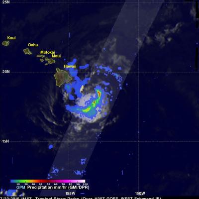
IMERG Shows Darby's Rainfall Over The Hawaiian Islands

Most of the Hawaiian Islands were spared serious damage from tropical storm Darby. The location of Darby's track through the Hawaiian Islands resulted in the islands of Hawaii and Oahu being the most affected. Flash flooding was common on Oahu due to a reported 177.8 mm (7 inches) of rain drenching the island. Interstate H-1 was flooded in some locations. Lightning damage was reported in Kaneohe on the windward side of Oahu. Estimates of rainfall accompanying tropical storm Darby were produced using NASA's Integrated Multi-satellitE Retrievals for GPM (IMERG) data. These IMERG rainfall

Tropical Storm Darby Brings Occasionally Heavy Rain To The Hawaiian Islands

Tropical storm Darby has caused some heavy rainfall in the Hawaiian Islands since hitting the big island (Hawaii) on Saturday July 23, 2016. After hitting the big island Darby passed to the south of Molokai and Maui. Rain falling at a rate of 25.4 mm (1 inch) to 50.8 mm (2 inches) per hour was reported on the island of Oahu as Darby passed to the southwest of the island. The National Weather Service office in Honolulu reported that parts of Interstate H-1 that serves the southern side of Oahu was closed due to flooding on Sunday night. Darby is affecting northern Kaui today. The GPM core

Forming Tropical Storm Darby Analyzed By GPM

Tropical storm Darby became the fourth eastern Pacific Ocean tropical storm to form on July 12, 2016. Last year was an El Nino year and this year is transitioning to a La Nina year with cooler sea surface temperatures (SST) expanding across the eastern equatorial Pacific Ocean. Fewer tropical storms are normally expected to develop in the eastern Pacific Ocean during La Nina years but so far this year tropical cyclones are forming in the eastern Pacific Ocean at about the same pace as last year. The GPM core observatory satellite flew above tropical depression five (TD05E) on July 12, 2016 at