Gaston

GPM Views Hurricane Gaston Eye Wall Replacement

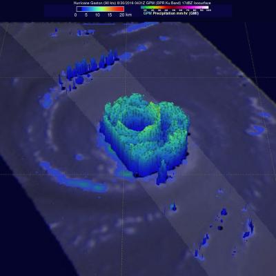
Hurricane Gaston was located in the central Atlantic Ocean west of Bermuda when the GPM core observatory satellite passed over on August 30, 2016 at 00:31 AM EDT (0431 UTC). Gaston was a category two on the Saffir-Simpson hurricane wind scale with maximum sustained winds of about 103.5 mph (90 kts). GPM happened to fly over as Gaston was undergoing an eye wall replacement. Intense rainfall was clearly shown by GPM in rain bands of both the inner and the outer replacement eye walls. Precipitation was calculated from data collected by GPM's Microwave Imager (GMI) and Dual-Frequency Precipitation

Gaston Hovers Around Hurricane Intensity as it Moves into the Central Atlantic

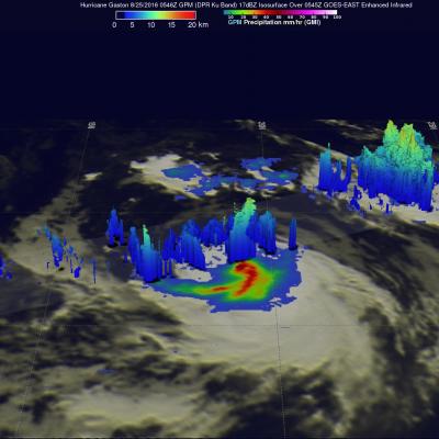
Gaston became the 3rd hurricane of the season early this morning (just after midnight EDT) as the storm was moving northwestward into the Central Atlantic about midway between the Leeward Islands and the Cape Verde Islands before weakening back into a tropical storm less than 12 hours later. Gaston is continuing to battle relatively strong environmental wind shear brought about by an upper-level low pressure center positioned to the west of Gaston. Winds flowing counter-clockwise around the upper low are blowing from the southwest while Gaston is moving northwest. These opposing winds are

GPM Observes Tropical Storm Gaston's Development

Tropical storm Gaston became the 7th named tropical storm in the Atlantic Ocean after forming southwest of the Cape Verde Islands on Monday evening August 22, 2016. Gaston's development followed closely behind tropical storm Fiona that formed in the same area southwest of the Cape Verde Islands on August 17, 2016. Fiona is now fading quickly in the Atlantic Ocean southwest of Bermuda. Tropical storm Gaston is predicted by the National Hurricane Center (NHC) to intensify and become a hurricane on August 24, 2016. Gaston is expected to move into the center of the Atlantic Ocean well east of