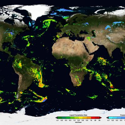
Hide Date

Thumbnail
Various ground validation instruments, including the Parsivel Disdrometer in Finland, a Micro Rain Radar, and a Pluvio Snow guage
GPM Ground Validation Data Homepage: http://gpm-gv.gsfc.nasa.gov/ GPM Ground Validation Data Access: https://ghrc.nsstc.nasa.gov/pub/fieldCampaigns/gpmValidation/ The goal of this site is to provide a one-stop-shopping portal for accessing the various radar, disdrometer, gauge and other instrument data sets supporting GPM GV activities. Use the tabs above to access the various datasets, including: Radar Gauge Disdrometer NOAA/NMQ Field Campaigns Validation Network Wallops Precipitation Research Facility Marquette data browser (GV data from the Marquette, Michigan NWS Snowfall Observation Site)
IMERG Grand Average Climatology 2001 - 2019
Map of Earth Showing the GPM Grand Average Climatology.
Thumbnail
Permissions for using imagery found on this website are the same as those listed in NASA's official Media Usage Guidelines For questions about permission for using NASA images and videos, please refer to NASA's official Media Usage Guidelines . For any additional questions please contact bert.ulrich@nasa.gov A few key points of NASA's media usage policy include: NASA content (images, videos, audio, etc) are generally not copyrighted and may be used for educational or informational purposes without needing explicit permissions. The NASA insignia logo (the blue "meatball" insignia), the retired
JAXA DPR Logo
One of the prime instruments onboard the GPM Core Observatory is the Dual-frequency Precipitation Radar (DPR). The DPR consists of a Ku-band precipitation radar (KuPR) and a Ka-band precipitation radar (KaPR). The KuPR, which operates at 13.6 GHz, is an updated version of the highly successful unit flown on the Tropical Rainfall Measuring Mission (TRMM). The KuPR and the KaPR are co-aligned on the GPM spacecraft bus such that the 5-km footprint location on the earth is the same.
GMI in Electromagnetic Interference Testing
The Global Precipitation Measurement (GPM) Microwave Imager (GMI) instrument is a multi-channel, conical- scanning, microwave radiometer serving an essential role in the near-global-coverage and frequent-revisit-time requirements of GPM. The instrumentation enables the Core spacecraft to serve as both a precipitation standard and as a radiometric standard for the other GPM constellation members. The GMI is characterized by thirteen microwave channels ranging in frequency from 10 GHz to 183 GHz. In addition to carrying channels similar to those on the Tropical Rainfall Measuring Mission (TRMM) Microwave Imager (TMI), the GMI carries four high frequency, millimeter-wave, channels near 166 GHz and 183 GHz. With a 1.2 m diameter antenna, the GMI provides significantly improved spatial resolution over TMI.
Thumbnail
The Global Precipitation Measurement (GPM) Core Observatory satellite operates in low Earth orbit, carrying two instruments for measuring Earth's precipitation and serving as a calibration standard for other members of the GPM satellite constellation. The satellite was developed and tested in-house at NASA Goddard Space Flight Center and launched from Tanegashima Space Center, Japan, on February 27th, 2014. The GPM Core Observatory orbits Earth at an inclination of 65 degrees, which enables it to cut across the orbits of other microwave radiometers and sample the latitudes where nearly all precipitation occurs. A non-sun-synchronous orbit that takes it around Earth roughly 16 times per day allows it to sample precipitation at different times of the day. Data is transmitted continuously to ground systems on Earth by the Tracking and Data Relay Satellite (TDRS) communications network.
IMERG Early Run Example January 24th, 2020
NASA’s Integrated Multi-satellitE Retrievals for GPM (IMERG) algorithm combines information from the GPM satellite constellation to estimate precipitation over the majority of the Earth's surface. IMERG is particularly valuable over areas of Earth's surface that lack ground-based precipitation-measuring instruments, including oceans and remote areas. IMERG fuses precipitation estimates collected during the TRMM satellite’s operation (2000 - 2015) with recent precipitation estimates collected by the GPM mission (2014 - present) creating a continuous precipitation dataset spanning over two decades. This extended record enables scientists to compare past and present precipitation trends, enabling more accurate climate and weather models and a better understanding of Earth’s water cycle and rainfall and snowfall patterns. IMERG also enables a wide range of applications to help communities around the world make informed decisions for disasters, disease, resource management, energy production, food security, and more.