Logo for GPM Applications showing ecology, water and agriculture, energy, disasters, health, and weather.

Applications Articles

GPM overpass of Hurricane Erin.
After forming into a hurricane in the central Atlantic on the morning of Friday August 15 th, Hurricane Erin underwent a period of extremely rapid intensification as it was passing northeast of the Leeward Islands, becoming a powerful Category 5 storm and the most rapidly deepening hurricane in the Atlantic before the month of September. Last year in early October in the then Gulf of Mexico, Hurricane Milton became the fastest Atlantic storm to intensify from a tropical depression to a Category 5 storm. Erin originated from an African easterly wave that emerged off the coast of Africa on the 9
IMERG Hurricane Harvey (2024) 30-minute summary
NASA's Worldview website now allows you to explore global estimates of rainfall and snowfall from 1998 to the present at 30-minute intervals. Researchers and application developers have been using this dataset since 2014 (Portier 2024; Portier et al. 2023), but now it is also available as images in Worldview.
3D view of the Texas storms from the GPM satellite
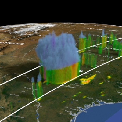
Over the fourth of July weekend, the Texas Hill Country was devastated by a powerful flash flood event. River levels rose rapidly, on the order of 20 feet or more in 1 to 2 hours or less, all along the upper part of the Guadalupe River. The main flood event started overnight and continued throughout the morning of July 4, resulting in widespread destruction, hundreds of water rescues, many deaths, and numerous people still reported as missing. The Hill Country can be susceptible to flash floods as water tends to run off rather than being absorbed by the soil and plants. The culprit for this
Map of the U.S. showing IMERG rainfall totals over the south and central U.S.
This past week, a slow-moving, upper-level system moving through the central U.S. triggered several days of severe weather. The system caused numerous tornadoes, as well as heavy rains and flooding from the Deep South up through the middle Mississippi River Valley and into the Ohio River valley. The situation began when an upper-level area of low pressure situated over the northeast Pacific pivoted down into the central Rockies, creating a deep trough of low pressure aloft that extended down into the northern Baja. This channeled strong jet stream winds from south of the Four Corners region up
top image for Sahara 2024
Most people live in places where it rains much more often than it does in the Sahara Desert. For this reason, it can be challenging to make sense of news reports of major storms in the Sahara. NASA satellite data and rainfall statistics can give the needed context. Below is a discussion of three news stories about rainfall in or near the Sahara Desert during August and September 2024. These news stories described storm runoff, infrastructure damage, and the rain's impact on the ecosystems at the edge of the desert. Areas with significant impacts are shown in green in Figure 1. Figure 1. A map
Screenshot of IMERG rain rates on October 29, 2024
During the 10-day period from Oct. 26 through Nov. 4, 2024, parts of central-eastern and southern Spain saw unusually heavy flooding that resulted in heavy infrastructure damage and over 200 fatalities, according to the Associated Press. In this animation, NASA’s IMERG multi-satellite data product shows estimated rain rates (blue/yellow shading) and accumulations (green/purple shading) from the flooding rainfall. Cloudiness is also shown in white/gray shading, from geosynchronous infrared satellite observations. Download video (right-click -> "Save As") The flooding was caused by heavy
Thumbnail
For the third consecutive year, NASA’s Global Precipitation Measurement Mission applications team and University of Coimbra’s Earth and Space Science Center (CITEUC Portugal) collaborated to host the GPM Mentorship Program. The 2024 initiative built on previous years' successes, supporting new and existing user communities and providing a tailored hands-on learning experience in using GPM data for applications. It gave participants an overview of state-of-the-art GPM satellite-based precipitation estimates and provided users with examples of applying GPM data to support real-world problems
Map IMERG rainfall totals from Milton.
While the GPM Core Observatory’s instruments show exceptional detail in Milton’s rainfall structure in several overpasses throughout the week, the IMERG global multi-satellite product provides a broader overview of precipitation along Milton’s track as a continuous picture from development through landfall. Download this video (right-click -> "save as") The above animation shows IMERG precipitation rates (in blue/yellow shading) and accumulations (in green/purple shading) from Oct. 5-10, 2024. Cloudiness is shown in shades of white/gray using infrared geosynchronous satellite data. While
GPM data shows precipitation within Hurricane Milton over the Gulf of Mexico on Oct. 7, 2024.
Updated Oct. 10, 2024 Click here for a visualization of IMERG precipitations and totals from Hurricane Milton. After forming in the Bay of Campeche, Hurricane Milton underwent a remarkable period of rapid intensification with its central pressure falling from 1007 mb (29.74 inches of mercury, inHg) at 11:00 a.m. EDT Oct. 5 to 897 mb (26.49 inHg) at 8:00 p.m. EDT on Oct. 7. At this time Milton became the fifth most intense hurricane in the Atlantic Basin on record in terms of central pressure, just behind Hurricane Rita (2005) on that list, and only the sixth storm in the Atlantic to have a
Map of IMERG rainfall totals from Hurricane Helene.
After tracking through the eastern Gulf of Mexico and battering much of the west coast of Florida with strong winds and storm surge, Hurricane Helene made landfall in the Big Bend region of Florida’s northwest coast at 11:10 pm EDT about 10 miles west-southwest of Perry, Florida, as a powerful Category 4 hurricane with maximum sustained winds reported at 140 mph by the National Hurricane Center (NHC). Hurricane Idalia, a strong Category 3 storm at the time, also made landfall in the Big Bend last year. Animation of NASA IMERG precipitation rates and totals from Hurricane Helene from Sept. 23 -

Hide Date