

Simon Ageet - Landslide Analysis and Mitigation Efforts Across Mt Elgon, Uganda
Overview: Hydrometeorological natural hazards are on the rise globally, yet in Africa, rainfall data which is crucial in mitigation efforts is lacking. Understanding the amount and distribution of rainfall and how it plays a role in causing these natural hazards is critical to improve disaster response and mitigation efforts. This project uses GPM IMERG data together with resources like NASA's Landslide Viewer to determine a precipitation threshold for landslides in the Mt. Elgon region of Uganda.
Mentors: Vasco Mantas, Zhong Liu, Andrea Portier, Dorian Janney
2022 GPM Mentorship Program
Simon Ageet - Landslide Analysis and Mitigation Efforts Across Mt Elgon, Uganda

Participant Name: Simon Ageet
Project: Landslide Analysis and Mitigation Efforts Across Mt Elgon, Uganda
Affiliation: Karlsruhe Institute of Technology, Germany
Current role: Doctoral Candidate
Mentors: Vasco Mantas, Zhong Liu, Andrea Portier, Dorian Janney
Download Project Overview Highlights (.pptx)
Download Final Presentation (.pdf)
Why are you participating in this program?
This program offered insights into some of the most widely used rainfall data alternatives, namely the GPM IMERG product, which was very appealing to me. Additionally, the program offered products geared directly towards addressing natural disasters, for example, landslide information. Lastly, the fact that the program was taught by leading scientist in precipitation products from NASA and highly-ranking universities was a great opportunity.
Tell us about your project:
Hydrometeorological natural hazards are on the rise globally, yet in Africa, rainfall data which is crucial in mitigation efforts is lacking. Understanding the amount and distribution of rainfall and how it plays a role in causing these natural hazards is critical in supporting meteorological and disaster agencies to make accurate predictions of weather and improve disaster response and mitigation efforts.
For this project, I used daily GPM IMERG Final rainfall data together with landslide resources, for example, the NASA Landslide Viewer Tool, to determine a precipitation threshold for landslides in the Mt. Elgon region of Uganda. This region is a landslide hot spot in Uganda, displacing thousands of people and causing loss of lives. I leveraged this information with limited information that is available by the government of Uganda. Specifically, I evaluated 29 landslide cases form the NASA Landslide catalogue against IMERG-F to determine if rainfall played a role in triggering the landslide. I also evaluated topography, population and land-use coverage for each of the landslide cases. Project findings showed a relationship between landslide events to rainfall, where exceptional precipitation events preceded landslides. Moreover, the events are concentrated in the rainy seasons. However, setting a precipitation threshold for this region is not easy as the amount of rainfall that triggered the landslides highly varied (including values below the long-term mean). A deeper analysis of the threshold, for example, by stratifying the cases by month could have been helpful but was not possible due data limitation.
Since precipitation is the main trigger of landslides, understanding and quantifying the critical thresholds as well as identifying existing and free natural hazard data platforms can continue to increase our understanding of how precipitation plays a critical role in natural disasters throughout Uganda. This information can help support and improve landslide forecasting efforts, and as a result can lead to enhanced mitigation efforts of landslide impacts over this region.
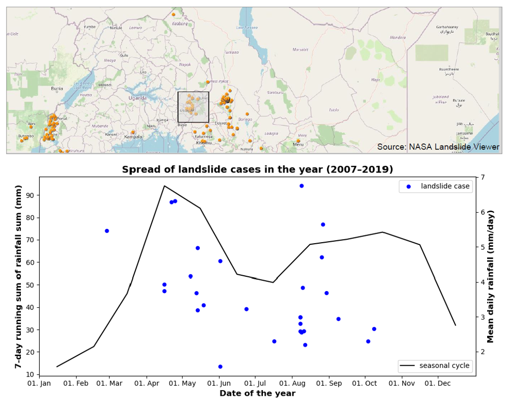
(Top) Inset map showing location of Mt. Elgon, Uganda, and highlighting the 29 landslide cases used for this study. (Bottom) Analysis of seasonal precipitation against landslide cases. Credits: S Ageet
What communities or organizations may benefit from your case study project?
The Uganda Weather Service, the Ministry of Disaster Preparedness under the Prime Minister's Office, the Uganda Red Cross, the National Environmental Management Authority, Climate Change Department, among others. All these organizations are taxed with providing information geared towards mitigating natural hazards like landslides and flooding.
What is something surprising that you have learned about the GPM mission, the data, or applying GPM data for applications?
There is a lot of useful information which is still unexplored for regions like Uganda. Most of the products are actually readily available and do not necessarily need advanced programming skills. So programs like this are eye-openers.
What is a challenge you faced with using remote sensing data? Any lessons learned that helped overcome this barrier?
Besides the rainfall data which is at a relatively high resolution, some of the products are global in nature and therefore at a coarser resolution, needing down-scaling, which needs regional data, which is often lacking.
How do you plan to use GPM in the future?
I plan to continue my project of analyzing landslide and floods cases over Elgon region and the other parts of Uganda. I also use GPM IMERG for other projects, for example analyzing the skill of weather forecasts over Uganda.