
Long-lived Tropical Cyclone Freddy Brings Heavy Rain and Flooding to Madagascar and Mozambique
Updated March 17, 2023
Originally Published March 3, 2023
--
Tropical Cyclone Freddy first made landfall along the east coast of Madagascar just north of the town of Mananjary on Feb. 21, 2023, as a Category 3 cyclone with average winds reported at ~81 mph (130 km/h) and gusts up to ~112 mph (180 km/h). After crossing over Madagascar Freddy continued westward over the Mozambique Channel before making landfall again along the east coast of Mozambique just south of Vilankulos as a moderate tropical storm with sustained winds estimated at 50 mph. Despite being weaker at landfall, Freddy caused widespread flooding across parts of Mozambique due to the storm stalling out near the coast after making landfall.
Incredibly, Freddy drifted back out over the Mozambique Channel, nearly making landfall along the southwest coast of Madagascar. It then changed direction, re-intensified, weakened, re-intensified one last time, and made landfall once again on March 11 near Quelimane, Mozambique, as a Category 1 cyclone with sustained winds reported at 90 mph.
Meteorologically, Freddy has been a remarkable storm, lasting over five weeks to become likely the longest-lived tropical cyclone in recorded history. Freddy originated from a weak area of low pressure that was embedded in a monsoon trough of low pressure stretching east-west across the Timor Sea between northern Australia and southern Indonesia. On Feb 6, 15 days before it would make its first landfall in Madagascar, both the Australian Bureau of Meteorology and the US Joint Typhoon Warning Center reported the formation of Tropical Cyclone Freddy about 420 miles northwest of the northwest coast of Australia. In a rare but not unprecedented event, Freddy tracked across the entire Indian Ocean from east to west in almost a straight line with very little deviation in latitude. Along the way, Freddy underwent four separate rapid intensification cycles, the first southern hemisphere storm in history to do so. After hitting Mozambique the first time and re-emerging back over the Mozambique Channel, Freddy underwent at two additional rapid intensification cycles resulting from the competing effects of warm water, wind shear and dry air. Freddy was also the first storm to the reach the equivalent of Category 5 intensity on the Saffir-Simpson scale for 2023. In addition to being likely the longest-lived tropical cyclone in recorded history, Freddy set the record for having the highest accumulated cyclone energy (ACE) of any storm in the Southern Hemisphere. ACE is an index used to measure the total amount of wind energy associated with a tropical cyclone over its lifetime.
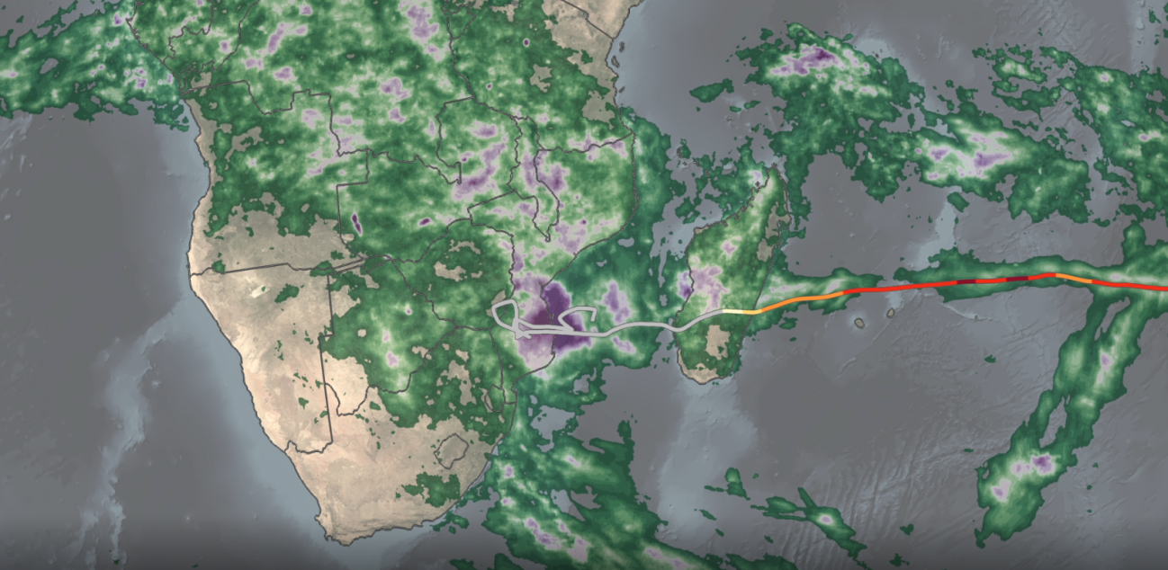
GPM IMERG precipitation rates and totals from Tropical Cyclone Freddy, Feb. 6 - March 12, 2023. Credit: NASA
Download in high resolution from the NASA Goddard Scientific Visualization Studio
NASA’s IMERG satellite precipitation product is ideal for monitoring and studying tropical cyclones around the world, especially over the open ocean where ground-based observations are sparse. IMERG uses precipitation estimates from a constellation of satellites united by the GPM Core Observatory to generate maps of global precipitation updated every 30 minutes in near real-time. The above animation shows IMERG surface rainfall estimates associated with the passage of Tropical Cyclone Freddy across the Indian Ocean as well as Freddy’s corresponding track and intensity. The animation begins at on Feb. 6, 2023, just before Freddy is about to form northwest of Australia. Over the course of the storm’s history, IMERG reveals a variety of precipitation features and trends that relate closely to the variations in Freddy’s intensity.
Tropical cyclones derive their energy from latent heating, which comes primarily from cloud condensation. Although essentially undetectable directly, the most significant latent heat release occurs within deep convective towers, which are associated with high cold cloud tops and areas of heavy rain at the surface. The IMERG animation illustrates this association between increased surface rain intensity and storm intensity - whenever Freddy undergoes a period of intensification, it is preceded by an increase in heavy rain. However, for the storm to really respond to the latent heating, that heating must occur near the storm’s center. For example, IMERG shows heavier rain on Feb. 8, but it is too far north of the center, and Freddy continues to weaken. Conversely, an absence of heavy rain near the center typically causes the storm to weaken. IMERG is also able to broadly resolve Freddy’s structure over the course of its lifetime, ranging from a highly asymmetrical rain field with most of the rain located on one side of the center, which occurs when the storm is weak or undergoing wind shear, to symmetrical when the storm is stronger, to having a full eye when the storm has an intense and well-developed circulation.
The end of the animation shows the total estimated rainfall for the entire period. IMERG shows that although heavy rain near the core of the storm is key to the storm maintaining or increasing in intensity, the highest overall rainfall totals are much more closely correlated to slow storm speed as evidenced by the extreme rainfall totals over Mozambique despite Freddy having weakened to a tropical storm. Here Freddy essentially stalls out for several days (Feb. 24 to March 2), allowing a sizeable portion of the storm’s circulation to remain over the warm waters of the Mozambique Channel and rainbands to continuously form and move inland. The result is rainfall totals on the order of ~16 to 31 inches (~400 to 800 mm, shown in purple) over parts of southern Mozambique and along the coast. Peak rainfall totals over Madagascar, where Freddy moved steadily across the island, are on the order of ~16 inches (400 mm). According to the latest media reports Freddy has been responsible for over 300 deaths in Mozambique, Madagascar and Malawi, and has caused widespread damage throughout these regions.
Credits:
Ryan Fitzgibbons (KBRwyle):
Lead Producer
Lead Video Editor
Aaron E. Lepsch (ADNET):
Technical Support
George Huffman (NASA/GSFC):
Lead Scientist
Lead Narrator
Jason West (ADNET):
Lead Visualizer
Stephen Lang (SSAI):
Lead Writer
Jacob Reed (Telophase):
Lead Story Editor