Madagascar

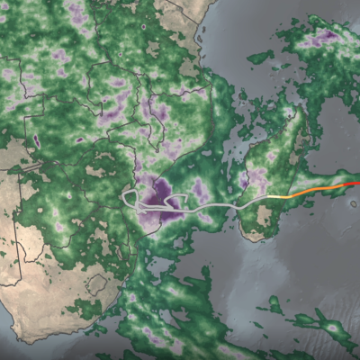
IMERG rainfall totals from Cyclone Freddy
Tropical Cyclone Freddy first made landfall along the east coast of Madagascar just north of the town of Mananjary on Feb. 21, 2023, as a Category 3 cyclone with average winds reported at ~81 mph (130 km/h) and gusts up to ~112 mph (180 km/h). After crossing over Madagascar Freddy continued westward over the Mozambique Channel before making landfall again along the east coast of Mozambique just south of Vilankulos as a moderate tropical storm with sustained winds estimated at 50 mph. Despite being weaker at landfall, Freddy caused widespread flooding across parts of Mozambique due to the storm stalling out near the coast after making landfall. Incredibly, Freddy drifted back out over the Mozambique Channel, nearly making landfall along the southwest coast of Madagascar. It then changed direction, re-intensified, weakened, re-intensified one last time, and made landfall once again on March 11 near Quelimane, Mozambique, as a Category 1 cyclone with sustained winds reported at 90 mph.

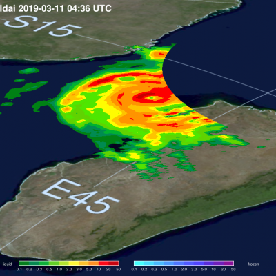
GPM Flies Over Developing Tropical Storm Idai Twice

Intense Tropical Cyclone Idai started as a tropical depression on the 4th of March, 2019, off the coast of Mozambique. After making landfall over Mozambique it turned back over the Mozambique Channel and strengthened to become a tropical cyclone on the 10th of March. The GPM satellite captured the cyclone with both the GPM Microwave Imager (GMI) and the Dual-frequency Precipitation Radar (DPR) on the 11th of March at 04:36 UTC when the storm was in the middle on the Mozambique Channel. The DPR captured a well-developed eye, seen at the center of the image. It flew over the storm once again at

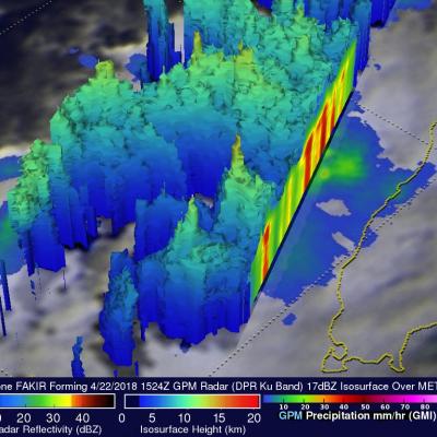
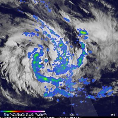
GPM Sees Tropical Cyclone Fakir Forming Near Madagascar

The southwest Indian Ocean cyclone season started on November 15, 2017 and will officially end on April 30, 2018. A tropical cyclone labeled FAKIR by Meteo France formed today near northeastern Madagascar. FAKIR is expected to intensify as it moves toward the southeast and could be a significant tropical cyclone tomorrow. This cyclone season has already seen Madagascar battered and drenched by tropical cyclones Ava, Dumazile, and Eliakim. The GPM core observatory satellite flew above the forming late season tropical cyclone near northeastern Madagascar on April 22, 2018. The satellite's

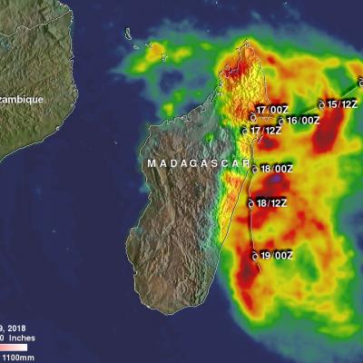
Tropical Cyclone Eliakim's Deadly Rainfall

Tropical cyclone ELIAKIMS's heavy rainfall caused flooding and landslides over eastern Madagascar that resulted in at least seven deaths. ELIAKIM came less than two weeks after another tropical cyclone called Dumazile passed close to Madagascar. ELIAKIM maintained but didn't exceed tropical storm intensity as it battered Madagascar. ELIAKIM's slower movement as it passed over the island nation caused continuous heavy rainfall over northeastern Madagascar. Tropical cyclone ELIAKIM has now moved back into the Indian Ocean and is moving toward the southeast and away from Madagascar. This rainfall

Forming Tropical Cyclone Near Madagascar Inspected By GPM

A new tropical cyclone may affect Madagascar in a few days. The Joint Typhoon Warning Center (JTWC) has been keeping an eye on an area of convection in the Indian Ocean northeast of Madagascar. A circulation center has already been observed. Environmental conditions are favorable for the birth of a tropical cyclone in that area with the presence of low vertical wind shear and warm sea surface temperatures. Tropical cyclone AVA caused many deaths in January when it's heavy rains caused extensive flooding in Madagascar. Tropical cyclone DUMAZILE also caused extensive flooding less than two weeks

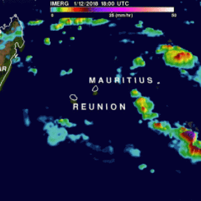
IMERG Reveals Rainfall Rates With Tropical Cyclone Berguitta

Tropical cyclone BERGUITTA formed in the southwestern Indian Ocean northeast of the islands of La Reunion and Mauritius on January 12, 2018. BERGUITTA is now moving toward the southwest and threatening the islands. Early on January 16,2018 BERGUITTA had maximum sustained winds estimated at 100 kts (115 mph). This means that BERGUITTA was the equivalent of a category three hurricane on the Saffir-Simpson hurricane wind scale. Later in the day BERGUITTA's maximum sustained wind speeds were estimated at 85 kts (98 mph) with gust to 105 kts (121 mph). On January 16, 2018 at 1200Z tropical cyclone

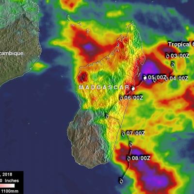
Tropical Cyclone Ava's Disastrous Rainfall Measured With IMERG

Tropical cyclone Ava dropped extremely heavy rainfall over Madagascar as it passed over the eastern side of the island country from January 5-6, 2018. Ava's drenching rainfall caused flooding and landslides which resulted in the deaths of at least 29 people. An estimated 80,000 people on Madagascar were affected by the tropical cyclone. This rainfall analysis was produced by accumulating rainfall that fell near Madagascar during the period from January 2-8, 2018. These IMERG estimates showed the locations of extreme rainfall totals during the period when tropical cyclone Ava was in Madagascar

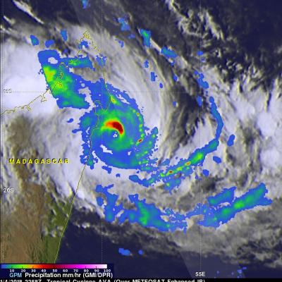
Tropical Cyclone Ava Viewed By GPM

Tropical cyclone AVA formed in the southeast Indian Ocean northeast of Madagascar on January 2, 2018. AVA became increasingly powerful and approached the eastern coast of Madagascar with maximum sustained winds estimated to be greater than 90 kts (103.5 mph). AVA has been interacting with land and wind speeds near Tamatave, Madagascar have been reported to be 70 kts (80.5 mph). The Joint Typhoon Warning Center (JTWC) predicts that tropical cyclone AVA will move to the south along Madagascar's eastern coast for a day or so and then return to the Indian Ocean. Very heavy rainfall is expected to

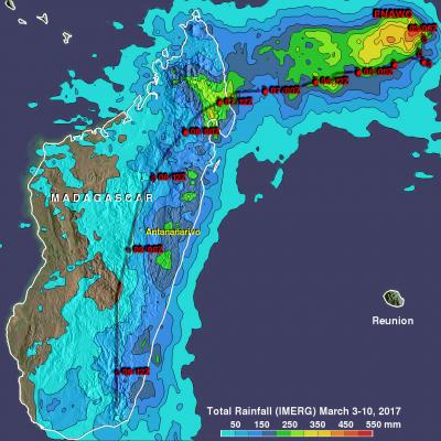
Tropical Cyclone Enawo's Rainfall Totals Updated With IMERG

Tropical cyclone Enawo is now responsible for the deaths of at least five people in Madagascar. Many thousands of people were also displaced due to flooding and destroyed homes. The tropical cyclone dropped heavy rainfall as it soaked the island from north to south. This rainfall analysis was updated to include recent precipitation estimates from NASA's Integrated Multi-satelliE Retrievals for GPM (IMERG) rainfall data. It shows rainfall estimates from IMERG data collected during the period from March 3-10, 2017. As expected, the eastern side of Madagascar had the highest rainfall total

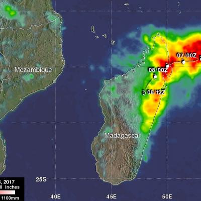
Deadly Tropical Cyclone Enawo Drenches Madagascar

Tropical cyclone Enawo hit Madagascar on Tuesday with powerful winds and drenching rain. At least three people have been reported killed by the tropical cyclone. Floods and landslides are likely as Enawo moves southward down the center of Madagascar. Tropical cyclones rotate in a clockwise direction in the southern hemisphere so the eastern side of Madagascar will have a strong onshore flow. The extreme amount of moisture flowing onto Madagascar from the Indian Ocean is expected to produce flooding and landslides. NASA's Integrated Multi-satelliE Retrievals for GPM (IMERG) data are produced