Articles

GPM Applications webinar banner
Did you know that GPM data has enabled people to better understand how water moves through our planet and make informed decisions that lead to improved outcomes for society? GPM continues to support a range of applications from water resource management, agriculture, vector- and water-borne disease monitoring, animal migration, tropical cyclone location and intensity estimation, hydropower management, flood and landslide monitoring and forecasting, and land system modeling, among others. Join us during this free webinar to learn about the multiple ways GPM is used throughout the world and gain a perspective from two GPM power users that help support weather forecasters and the ecological community.
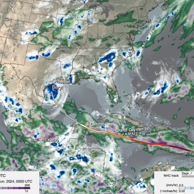
Screenshot of IMERG animation of Hurricane Beryl
On the morning of Sunday, June 30, Hurricane Beryl became a rare early season major hurricane when it reached Category 3 status with sustained winds of 115 mph as it was moving across the Atlantic 420 miles east-southeast of Barbados in the direction of the Leeward Islands. Then, just a few hours later at 11:35 a.m. EDT, Beryl became the earliest Category 4 hurricane on record in the Atlantic with sustained winds reported at 130 mph by the National Hurricane Center (NHC), surpassing Hurricane Dennis from the epic 2005 Atlantic hurricane season. Beryl also became historic as the strongest and
Webinar 7 banner: PRecipitation Data
August 1, 2024, 8:00 p.m. ET Register Here Overview Every second of every day, NASA satellites are collecting data to help us better understand and protect our home planet. Have you ever wondered what kinds of data NASA collects and how you can access it? Join us and find out how and why we use Earth-observing satellites to collect data, where you can access this free and openly sourced data, and how various NASA-sponsored programs are helping make data understandable and accessible to everyone. Resources: Resource packet Speakers Elizabeth Joyner Elizabeth Joyner serves as Community
GPM 10-in-10 Banner showing the GPM satellite over Earth sensing precipitation.
Have you ever wondered how Earth observing satellites are able to measure things like precipitation, temperature, and other phenomenon from space? Join us during this free webinar to learn about “remote sensing” and gain an understanding of how and why we use satellites to help us understand and protect our home planet.
GPM 10-year banner
Too little or too much precipitation can mean the difference between life and death. Join us as we learn about the impacts of having too much or too little precipitation and the disasters that can occur as a result. Discover what we are learning about the connection between extreme weather events and climate change. Find out the many ways that NASA is helping us monitor and respond to natural hazards and disasters.