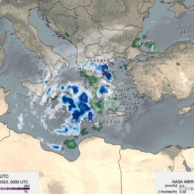
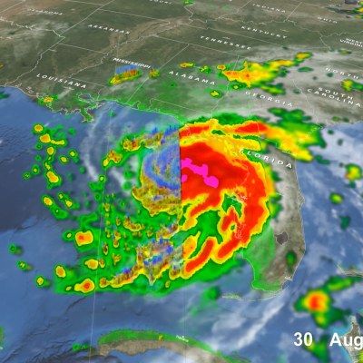
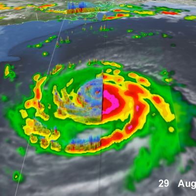
Articles

Photo of María Paula Hobouchian
Overview: Argentina has a low-density rain gauge network. As a result, there are often challenges in representing accurate estimates of precipitation. Satellite quantitative precipitation estimates (SQPEs) derived from satellite measurements can help fill these gaps and serve a critical role in hydrological and weather forecasting applications. This project explores different gauge bias correction methods of SQPE products using the IMERG Early Run in Argentina to improve SQPE data products. Mentor: Joe Turk
Photo of Charlene Gaba
Overview: This project evaluates the GPM IMERG Late product against ground data to develop applications for a hydrological modelling online platform. Mentor: Mircea Grecu
GPM overpass of Typhoon Nanmadol
Super Typhoon Nanmadol became one of the strongest typhoons to threaten Japan since records began in 1951. Nanmadol began as a tropical disturbance, basically an area of active thunderstorms, on September 11th southeast of Iwo Jima about midway between Tokyo and Guam. After moving to the southwest for 2 days, this disturbance became better organized and formed into a depression on the 13th. The system then made a counterclockwise loop, moving first back to the northeast before turning back again towards the west. Over this time, the system slowly intensified, becoming Tropical Storm Nanmadol
Photo of Odina Echeta
Overview: This project works to validate the GPM dual-frequency precipitation radar (DPR) merged scan product against a quality-controlled ground reference data (GV-MRMS) in the continental US. Knowledge from this concept study will be applied to validating/ evaluating and selecting remotely-sensed satellite rainfall products that could be useful for rainfall estimation in data-scarce regions such as West Africa. Mentors: Yagmur Derin , Pierre Kirstetter
Photo of Chuntao Liu
Affiliation: Texas A&M University – Corpus Christi, Corpus Christi, Texas, USA Project Mentees: Eva Yamamoto , June Choi ; Nimisha Wagle