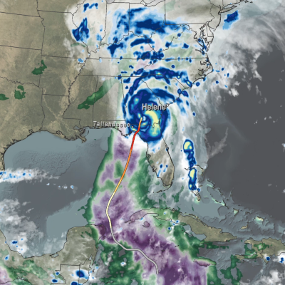
Articles

GPM Overpass of Typhoon Khanun
The Northwest Pacific typhoon season has been quite active recently. Following in the wake of Super Typhoon Doksuri, which skirted the northern tip of Luzon July 25 and 26 and continued on to bring extreme rainfall to southeast coast of China, is yet another powerful storm - Typhoon Khanun. Khanun (known as “Falcon” in the Philippines) began in the West Pacific Ocean as an area of disturbed weather on July 24 situated well south of Guam and east of Palau. Over the next several days the system slowly intensified as it tracked northwestward towards the Ryuku Islands of southern Japan, becoming a
GPM Overpass of Hurricane Calvin on July 14
After a quiet start, the 2023 eastern Pacific hurricane season recently picked up in activity with the formation of the season’s first major hurricane, Hurricane Calvin. Calvin originated on July 11 from an area of low pressure located about 510 miles (~820 km) south-southwest of Manzanillo, Mexico, which had become organized enough for the National Hurricane Center (NHC) to declare it Tropical Depression 3E (TD 3E) that afternoon. Located over warm sea surface temperatures (SSTs) of around 84 oF (29 oC), thunderstorm activity near the center of TD 3E continued to increase overnight, and
GPM Core Observatory data of precipitation within Typhoon Mawar
Driven by powerful winds and intense rainfall, Typhoon Mawar emerged as a rapidly intensifying storm in the western Pacific Ocean. Originating from a tropical disturbance, the typhoon swiftly developed into a significant weather system, eventually making landfall on the U.S. territory of Guam on May 25, 2023, as a Category 4 typhoon. After hitting Guam, it further intensified into a Category 5 typhoon, making it one of the most powerful storms on record in the month of May. Download this video from the NASA Goddard Scientific Visualization Studio The combination of NASA’s IMERG precipitation
IMERG rainfall totals from Cyclone Freddy
Tropical Cyclone Freddy first made landfall along the east coast of Madagascar just north of the town of Mananjary on Feb. 21, 2023, as a Category 3 cyclone with average winds reported at ~81 mph (130 km/h) and gusts up to ~112 mph (180 km/h). After crossing over Madagascar Freddy continued westward over the Mozambique Channel before making landfall again along the east coast of Mozambique just south of Vilankulos as a moderate tropical storm with sustained winds estimated at 50 mph. Despite being weaker at landfall, Freddy caused widespread flooding across parts of Mozambique due to the storm stalling out near the coast after making landfall. Incredibly, Freddy drifted back out over the Mozambique Channel, nearly making landfall along the southwest coast of Madagascar. It then changed direction, re-intensified, weakened, re-intensified one last time, and made landfall once again on March 11 near Quelimane, Mozambique, as a Category 1 cyclone with sustained winds reported at 90 mph.
Thumbnail
The second edition of the Global Precipitation Measurement Mission (GPM) Mentorship program is now open for registration. Limited seats are available.