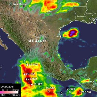
Articles

A Tale of Two Extremes: Rainfall Across the US
The United States has seen a tale of two extremes this year, with drenching rains in the eastern half of the country and persistent drought in the west. A new visualization of rainfall data collected from space shows the stark contrast between east and west for the first half of 2015. The accumulated precipitation product visualized here begins on Jan. 1, 2015, and runs through July 16, 2015. This visualization shows the heavy rainfall throughout Northern Texas and across Oklahoma as well as the drought in Southern California. Credits: NASA Goddard's Scientific Visualization Studio Download...
California “Rain Debt” Equal to Average Full Year of Precipitation
California's accumulated precipitation “deficit” from 2012 to 2014 shown as a percent change from the 17-year average based on TRMM multi-satellite observations. Credits: NASA/Goddard Scientific Visualization Studio A new NASA study has concluded California accumulated a debt of about 20 inches of precipitation between 2012 and 2015 -- the average amount expected to fall in the state in a single year. The deficit was driven primarily by a lack of air currents moving inland from the Pacific Ocean that are rich in water vapor. In an average year, 20 to 50 percent of California's precipitation...
Satellite-Based Flood Monitoring Central to Relief Agencies' Disaster Response
In January 2015, the Shire River in Malawi, and Zambezi River in Mozambique were under tight scrutiny. Weeks of torrential rains led these and other rivers to burst their banks displacing 390,000 people across the region. In southern Malawi 220,000 acres of farmland were turned into a lake, cutting off roads and stranding thousands of people on patches of high ground. The flood was devastating for the country, but within 72 hours of it being declared an emergency the United Nations World Food Programme (WFP) was on the ground distributing food to residents. The quick response was supported by...
Using NASA Data to Show How Raindrops Could Save Rupees
Rainwater could save people in India a bucket of money, according to a new study by scientists looking at NASA satellite data. The study, partially funded by NASA’s Precipitation Measurement Missions, found that collecting rainwater for vegetable irrigation could reduce water bills, increase caloric intake and even provide a second source of income for people in India. The study, published in the June issue of Urban Water Journal, is based on precipitation data from the Tropical Rainfall Measuring Mission (TRMM), a joint mission between NASA and the Japan Aerospace Exploration Agency, which...
GPM Sees Tropical Storm Bill Over Texas
Download in hi-res from the NASA Goddard Scientific Visualization Studio Tropical Storm Bill made landfall over Texas at approximately 11:45am CST on June 16, 2015. Shortly after midnight, GPM passed over the storm as it slowly worked it's way northward across the already drenched state of Texas. This visualization shows Bill at precisely 12:11:27am CST (6:11:27 GMT) on June 17, 2015. The GPM Core Observatory carries two instruments that show the location and intensity of rain and snow, which defines a crucial part of the storm structure – and how it will behave. The GPM Microwave Imager sees...