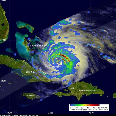
Articles

GPM flying over Earth with a data swath visualized.
A key component of the TRMM project is the Ground Validation (GV) effort which consists of collecting data from ground-based radar, rain gauges and disdrometers. The data is quality-controlled, and then validation products are produced for comparison with TRMM satellite products. The four primary GV sites are Darwin, Australia; Houston, Texas; Kwajalein, Republic of the Marshall Islands; and, Melbourne, Florida. A significant effort is also being supported at NASA Wallops Flight Facility (WFF) and vicinity to provide high quality, long-term measurements of rain rates (via a network of rain...
GPM flying over Earth with a data swath visualized.
Precipitation Measurement Mission Science NASA’s Precipitation Measurement Missions (PMM) develop and deploy advanced space-borne sensors to gain physical insights into precipitation processes and to enable improved monitoring and forecasting of climate, weather and precipitation-related natural hazards. PMM includes the Tropical Rainfall Measuring Mission (TRMM) and the Global Precipitation Measurement (GPM) mission. TRMM and GPM pursue a unique and innovative approach to measuring precipitation from space through the collection of observations by both active and passive sensors, which are...
GPM flying over Earth with a data swath visualized.
The NASA NPOL radar is a research grade S-band, scanning dual-polarimetric radar. The NPOL underwent a complete antenna system upgrade in 2010 and is one of two fully transportable research-grade S-band systems in the world. It is used to make accurate volumetric measurements of precipitation including rainfall rate, particle size distributions, water contents and precipitation type. Click here to view the latest NPOL data from the GPM Precipitation Science Research Facility at Wallops Flight Facility. Examples of NPOL-Generated Images
The NPOL instrument, a large radar dish attached to a trailer under a blue sky
To gain a better understanding of precipitation processes and to assess and refine the physical assumptions that go into the GPM algorithms, the ground validation team makes field measurements of specific parameters that describe the physical characteristics and variability of rainfall, including rainfall intensity, distribution, particle shape and precipitation type. Ground validation uses specific ground instrumentation infrastructure developed to observe, quantify and document the physical properties of precipitation. These instruments include: The NASA NPOL radar A research grade S-band...
GPM flying over Earth with a data swath visualized.
Integrated hydrologic validation assesses GPM precipitation products by considering how the accuracy of rainfall products being input into hydrological and land-surface modeling affects model outputs. The end goals are to evaluate satellite precipitation measurements for their impacts and utility, and to provide guidance to algorithms that turn satellite retrievals into meaningful estimates of precipitation. The integrated hydrologic modeling process provides a vehicle to evaluate precipitation inputs over a given hydrological basin (watershed) where the surface inputs (land cover, soil type)...