Bay of Bengal

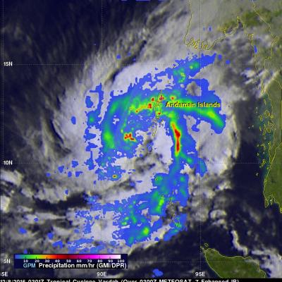
GPM Sees Possible Tropical Cyclone Forming In The Bay Of Bengal

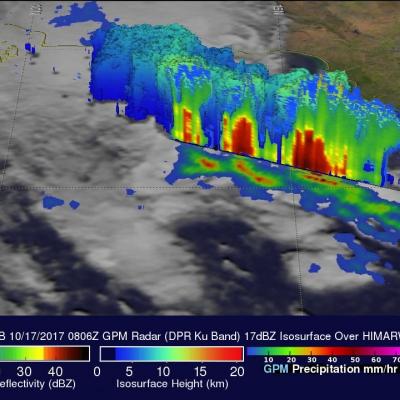
On October 17, 2017 at 0806 UTC the GPM core observatory satellite passed above a low pressure center in the western Bay Of Bengal where a tropical cyclone is probably forming. Warm sea surface temperatures in the Bay Of Bengal are supplying the necessary energy but moderate vertical wind shear observed to the south of the low are counteracting tropical cyclone development. Rainfall rates within the potential tropical cyclone were estimated using data collected by GPM's Microwave Imager (GMI) and Dual-Frequency Precipitation Radar (DPR) instruments. Extremely heavy rainfall accompanied strong

GPM Sees Tropical Cyclone Vardah (05B) Intensifying

The GPM core observatory satellite had another excellent view of tropical cyclone Vardah (05B) in the eastern Bay of Bengal on December 8, 2016 at 0301 UTC. GPM found that Vardah had become better organized since it formed on December 7, 2016. Maximum sustained winds had increased to an estimated 45 kts (~52 mph). GPM's Microwave Imager (GMI) showed that two intense feeder bands were bringing moisture from the Andaman Sea into the northeastern side of the tropical cyclone. GPM's Dual-Frequency Precipitation Radar (DPR) coverage is shown in a slightly lighter shade through the center of the

TRMM Sees Intensifying Cyclone Hudhud

The TRMM satellite flew over intensifying cyclone Hudhud in the Bay Of Bengal on October 10, 2014 at 0945 UTC.A Rainfall analysis from TRMM's Microwave Imager (TMI) instrument and Hudud's track is shown here. Cyclone Hudhud's is predicted to become a powerful category three tropical cyclone (on the Saffir-Simpson hurricane scale) with sustained winds peaking at 100 kts (115 mph) before hitting India's east coast in a couple days.

TRMM Again Examines Energetic 92B

The tropical disturbance (92B) in the Bay Of Bengal was raining heavily when the TRMM satellite flew almost directly above on May 21, 2014 at 0051 UTC. TRMM's Precipitation Radar (PR) revealed that rain was falling at the extreme rate of over 191 mm/hr (about 7.5 inches) in powerful convective storms in the center of the Bay Of Bengal well to the east of India. TRMM's Precipitation Radar data were also used to construct this simulated 3-D view, looking toward the east from India, of 92B's rainfall structure. TRMM PR pulled away a veil of clouds and revealed that some powerful convective storm

TRMM Sees Stormy Bay Of Bengal

On May 19, 2014 at 1056 UTC TRMM flew over a tropical low (92B) in the Bay Of Bengal east of India. TRMM's Precipitation Radar (PR) instrument found that rain was falling at a rate of over 138 mm/hr (about 5.4 inches) in some strong convective storms. A rainfall analysis from TRMM's Microwave Imager (TMI) and Precipitation Radar (PR) data is shown overlaid on a METEOSAT-7 visible/infrared image captured at 1100 UTC . TRMM PR data were also used in this 3-D image that shows a simulated view of the tropical disturbance's rainfall structure. Tall storms were shown reaching heights of over 14km

Tropical Cyclone Lehar In The Bay Of Bengal

Today tropical cyclone LEHAR's estimated sustained wind speeds reached 65kts (~75 mph). The most powerful tropical cyclone in the Bay Of Bengal this year was deadly tropical cyclone PHAILIN that moved through the area in October with wind speeds of 140kts (~161 mph). This means that LEHAR is the second most powerful tropical cyclone to form in the Bay Of Bengal this year. The TRMM satellite collected data used in the image on the left when the TRMM satellite passed above LEHAR on November 24, 2013 at 1812 UTC. At that time LEHAR was intensifying with tropical storm force winds estimated to be

TRMM Used to Examine the Bay of Bengal Tropical Cyclone

The accurate measurement of the tropical rainfall around the globe is one of the main objectives of the TRMM satellite. The TRMM satellite has also proven useful for global monitoring of tropical cyclone development. The images above were made from data received by the TRMM satellite when it passed over tropical cyclone 02B in the eastern Bay Of Bengal on 19 October 2011 at 2340 UTC. The image above shows a rainfall analysis that was made from TRMM's Microwave Imager (TMI) and Precipitation Radar (PR) data. It shows that moderate to heavy rainfall associated with 02B was extending