heavy rain

GPM Views Severe Rain Storms Over Western Saudi Arabia

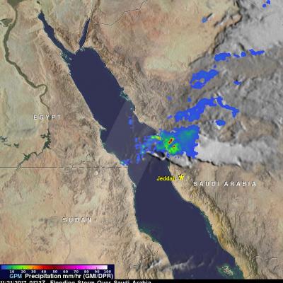
Intense rain storms have moved into Jeddah, Saudi Arabia today. Heavy downpours caused schools and universities to close. The General Authority of Meteorology and Environment Protection predicts that Heavy rain will continue for a couple days. NASA's GPM Core Observatory satellite measures precipitation from space with the first space-borne Ku/Ka-band Dual-frequency Precipitation Radar (DPR) and a multi-channel GPM Microwave Imager (GMI). The satellite passed over western Saudi Arabia on November 21, 2017 at 0123Z. GPM's Microwave Imager (GMI) and Dual-Frequency Precipitation Radar (DPR)

Extreme U.S. Rainfall Analyzed With IMERG Data

Tornadoes have accompanied severe weather over the United States almost daily during the past week. Severe storms spawned tornadoes from Texas and Oklahoma eastward through Mississippi. Upper Midwest states such Illinois, Indiana and Kentucky were also visited by tornadoes. Extreme rainfall caused deadly flooding in Missouri. More than a dozen people in the Midwest and South have been reported killed by tornadoes or flooding. The same weather system is spreading severe storms through East and Northeastern states today. NASA's Integrated Multi-satelliE Retrievals for GPM (IMERG) data were used

Pineapple Express Delivers Heavy Rains, Flooding, Drought Relief to California

An atmospheric river (“Pineapple Express”) delivered over 5 inches of rainfall in parts of California during January 3-10, 2017 (bottom) as viewed by GPM’s IMERG data. California, which has long been suffering through a strong, multi-year drought, is finally beginning to see some much needed relief as a result of a recent series of storms that are part of a weather pattern known as the “Pineapple Express.” The Pineapple Express is known as an atmospheric river. A large, slow-moving low pressure center off of the West Coast taps into tropical moisture originating from as far south as the

Deadly Tropical Rainfall Examined by IMERG

Scattered to numerous showers and scattered thunderstorms have occurred over Hispaniola during the past week. Slow moving frontal systems draped over Hispaniola and a tropical wave recently caused heavy rainfall that led to wide spread flooding over the northern Dominican Republic. Over 20,000 people have been displaced from their homes and at least five deaths have been reported. A broad area of low pressure (90L) in the southwestern Caribbean is also being monitored for possible tropical cyclone development by the National Hurricane Center (NHC). Very warm sea surface temperatures and upper

Deadly Hurricane Matthew's Total Rainfall

Hurricane Matthew devastated western Haiti and killed over 1,000 people. Matthew also took the lives of at least 37 deaths in the United States with 18 deaths occurring in the state of North Carolina. Flooding is still widespread in North Carolina. Some rivers in North Carolina such as the Tar and the Neuse are still rising. This rainfall analysis was accomplished using data from NASA's Integrated Multi-satelliE Retrievals for GPM (IMERG). IMERG is a unified U.S. algorithm that provides a multi-satellite precipitation product. IMERG is run twice in near-real time with the “Early” multi

GPM Gets a Closer Look at Louisiana Floods

Submitted by JacobAdmin on Thu, 09/29/2016
Video Embed

This visualization begins with an overview of the United States showing the clouds and rainfall accumulation of the massive rain event over Louisiana beginning on August 11th, 2016 through August 13th, 2016. The camera then begins to zoom in as time resets to August 11th. Time then slows way down on August 12th to show the first of GPM's passes. In this close up of GPM's volumetric DPR data over Louisiana, a cutting plane materializes into view to show the inner structure of this giant storm system.

Extreme Rainfall Along the Gulf Coast Measured by IMERG

For the better part of a week, a persistent, mid-level area of low pressure has been tapping into warm, moist air to produce stormy weather in the northeastern Gulf Of Mexico. The National Hurricane Center (NHC) monitored this stormy area for possible development but unfavorable upper-level winds and the close proximity to land prevented development into a tropical system. However, during the past week from as much as 4 to over 15 inches (254-381 mm) of rain fell along the Gulf Coast from Tampa northward through the Big Bend to as far west as central Louisiana. So far the highest rainfall

IMERG Measures West Virginia's Deadly Flooding Rainfall

Since last Thursday over two dozen people have been reported killed and hundreds of homes have been destroyed by flooding in West Virginia. The governor of the state declared a federal disaster after the worst flooding in a century. The prevalence of rough terrain in West Virginia has amplified the effects of flooding rainfall. The National Weather Service predicted that thunderstorms were going to fall in the area again today. More flash flooding with streams again coming out of their banks has been predicted. NASA's Integrated Multi-satellitE Retrievals for GPM (IMERG) data were used in this

IMERG Sees Onset Of Possibly Wetter India Monsoon

On June 8 the nodal weather agency of India (IMD) declared the arrival of the 2016 Southwest Monsoon over the Indian state of Kerala. This season is expected to be rainier than recent years. The El Nino conditions which have been blamed for recent disappointing monsoons has weakened to ENSO-neutral conditions. ENSO-neutral conditions are expected to transition to La Nina in the northern hemisphere by the fall and winter of 2016-17. La Nina conditions normally result in beneficial wetter and cooler monsoons in India. An animation of weekly rainfall totals was derived from NASA's Integrated

Severe Weather In Tornado Alley And Eastward (May 2nd Update)

Severe spring thunderstorms frequently spawned tornadoes from the Gulf Coast north and eastward during the past seven days. From April 25 to May 2, 2016 there were over 67 tornadoes in the United States reported to the National Oceanic and Atmospheric Administration (NOAA). Many of these tornadoes were located in an area that includes the states of Texas, Oklahoma, Kansas, and Nebraska. This area of the Great Plains has been labeled Tornado Alley due to the many tornadoes that occur there this time of year. Gulf moisture clashing with frontal systems moving over the United States provided much