India

TRMM Sees Powerful Storms In Tropical Cyclone Madi

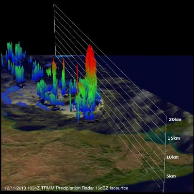
The TRMM satellite flew over tropical cyclone Madi in the Bay Of Bengal on December 11, 2013 at 1034 UTC. TRMM's Microwave Imager (TMI) and Precipitation Radar (PR) instruments found that Madi contained powerful storms southeast of Madi'a center of circulation dropping rain at the rate of over 81 mm/hr (~3.2 inches). An analysis of Madi's 3-D vertical structure using TRMM PR found that tops of these convective towers were reaching extremely high altitudes greater than 19km(~11.8 miles). Tropical cyclone Madi is predicted by the Joint Typhoon Warning Center (JTWC) to weaken while moving over

Tropical Cyclone Lehar Moving Toward India

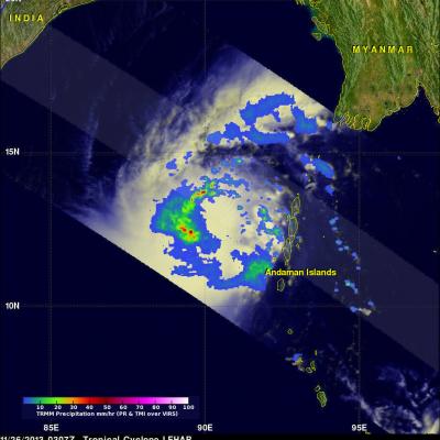
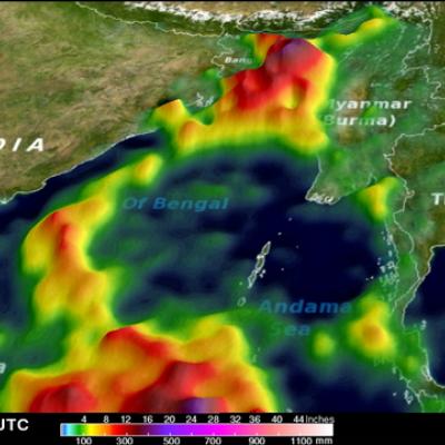
Tropical cyclone LEHAR, located in the Bay Of Bengal, continues to gain intensity while heading toward the same area of India where a much weaker tropical cyclone HELEN recently came ashore. The Joint Typhoon Warning Center (JTWC) predicts that LEHAR's sustained wind speeds will reach 95 kts (~109 mph) on November 27, 2013 and then decrease to about 85 kts (~98 mph) before hitting India's east-central coast. The TRMM satellite flew above tropical cyclone LEHAR on November 26, 2013 at 0307 UTC and captured data used in the image above. Rainfall derived from TRMM's Microwave Imager (TMI) and

Tropical Cyclone Helen Hits India

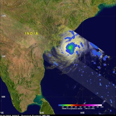
Tropical cyclone Helen was the fourth named tropical cyclone in the Bay Of Bengal this year when it formed on November 19, 2013. The image on the left shows tropical cyclone Helen as the TRMM satellite flew over on November 21, 2013 at 0606 UTC when Helen had reached peak intensity of about 60kts (~69 mph). The image on the right uses data captured on November 22, 2013 at 0510 UTC when tropical cyclone HELEN was hitting India's east-central coastline. Precipitation data derived from TRMM's Microwave Imager (TMI) and Precipitation Radar (PR) instruments show that Helen was dropping rain at a

Western India's Intense Monsoon Rain

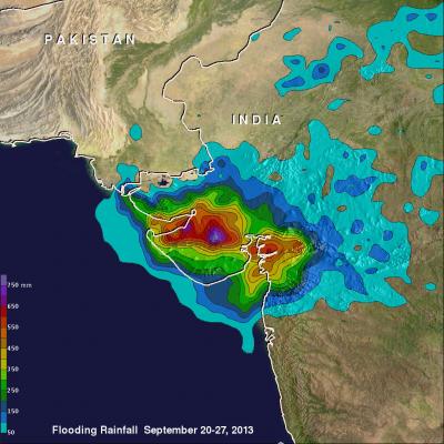
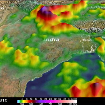
Western India has been having intense monsoon rainfall since September 21, 2013. This has resulted in widespread flooding in the west Indian state of Gujarat and reports of at least three related deaths. India had record breaking flooding in the northern state of Uttarakhand in June 2013 with more than 6,000 people killed. Near real-time TRMM Merged HQ/Infrared Precipitation (3B42) data were used in the rainfall analysis above. Rainfall total estimates from these space satellite data for the seven day period from September 20-27, 2013 were used. The highest totals of almost 800mm (~31.5 inches

Extreme India Monsoon Rainfall Analyzed

Extreme, sometimes disastrous, monsoon rainfall has occurred so far over India during June and July 2013. The image above shows rainfall total estimates from space satellite data for the seven day period ending on June 17, 2013. Near real-time TRMM Merged HQ/Infrared Precipitation (3B42) data, with seven days totals, were analyzed for the period from June 14-July 25, 2013. These rainfall estimates are shown in simulated 3-D perspective views with higher precipitation amounts appearing to be taller than lower amounts. Rainfall totals were also color enhanced with lower amounts being assigned

Deadly Tropical Cyclone Mahasen Comes Ashore

Tropical cylone Mahasen hit southern Bangladesh causing the reported deaths of at least 12 people and the destruction of many homes. Mahasen had heavy rains accompanied with tropical storm force winds when it came ashore. The TRMM satellite had two very informative views as deadly tropical Cyclone Mahasen was moving toward and then over Bangladesh. TRMM passed above Mahasen on May 15, 2013 at 2133 UTC and saw Mahasen again on May 16, 2013 at 0406 UTC after the tropical cyclone's center passed over Bengladesh's Ganges Delta. Red tropical cyclone symbols mark Mahasen's locations with both TRMM

Tropical Cyclone Thane Hits India

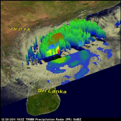
At least 33 people were killed when tropical cyclone Thane with reported winds of up to 85 mph hit the southeastern coast of India Friday morning. The TRMM satellite saw the tropical cyclone several times from it's birth in the Bay of Bengal to it's strengthening to hurricane force before penetrating the Indian coast. Thane was a tropical storm with winds of about 40kts when TRMM passed above on 26 December 2011 at 1305 UTC. The storm was starting to organize with TRMM Precipitation Radar (PR) revealing a large area of powerful storms surrounding the northern side. A TRMM Microwave Imager (TMI