Ophelia

Powerful Hurricane Ophelia Seen Heading Toward Ireland

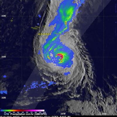
The GPM core observatory passed directly above hurricane Ophelia on October 14, 2017 at 1656 UTC. Ophelia was a powerful category three on the Saffir-Simpson hurricane wind scale with sustained winds of close to 115 mph (100 kts). GPM's Microwave Imager (GMI) and Dual-Frequency Precipitation Radar (DPR) instruments collected data showing the locations of extremely heavy rainfall with the hurricane. GPM's radar unveiled intense downpours in the northeastern side of Ophelia's eye that were dropping rain at the extreme rate of over 8.4 inches (213 mm) per hour. Other intense feeder bands with

Strengthening Tropical Storm Ophelia Observed By GPM

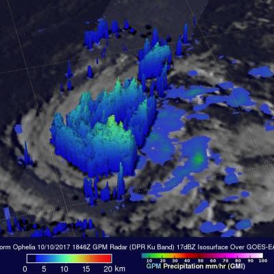
On Monday October 9, 2017 at 1100 AM AST (1500 UTC) tropical depression seventeen (TD17) was upgraded to tropical storm Ophelia. The tropical storm is located over the open waters of the the eastern Atlantic southwest of the Azores. The GPM core observatory satellite had a good view of tropical storm Ophelia on October 10, 2017 at 2:46 PM AST (1846 UTC). GPM's Microwave Imager (GMI) and Dual-Frequency Precipitation Radar (DPR) revealed that the storm was organized but most of the rainfall in the storm was only of light to moderate intensity. The area covered by GPM's 151.9 mile wide (245 km)

TRMM Sees CAT 4 Ophelia

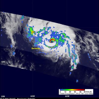
Ophelia was a very powerful category four hurricane on the Saffir-Simpson scale with winds of over 115 kts (~132 mph) when TRMM passed over head on 2 October 2011 at 0049 UTC. The Infrared image from that orbit shows that Ophelia had a small clear eye as it was passing well to the east of Bermuda. TRMM's Microwave Imager (TMI) and Precipitation Radar (PR) data revealed that heavy rainfall was located in the northern side of the eye wall.

Ophelia Becomes a Hurricane

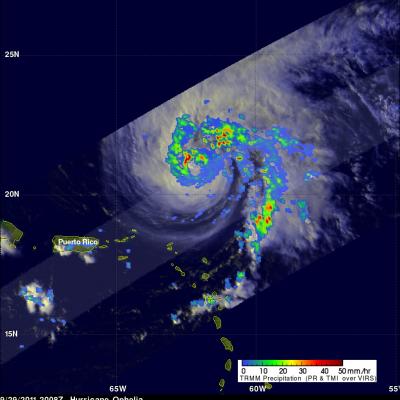
The TRMM satellite saw tropical storm Ophelia on 29 September 2011 at 2008 UTC ( 4:08 PM EDT) shortly before the storm was upgraded to a hurricane by the National Hurricane Center (NHC). An analysis of rainfall from TRMM's Microwave Imager (TMI) and Precipitation Radar (PR) data shows that Ophelia was developing an eye with powerful thunderstorms located in the northwestern side of the forming eye wall. On Friday 30 October 2011 Ophelia further intensified to become a powerful category three hurricane on the Saffir-Simpson scale with winds of 100kts (~115 mph). The NHC has predicted that this
Ophelia Reviving and Philippe Weakening JacobAdmin Tue, 09/27/2011
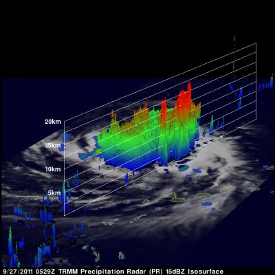
The TRMM satellite passed above two tropical cyclones in the Atlantic Ocean early today. Tropical storm Philippe was seen at 0358 UTC (12:58 PM EDT 26 September 2011) and the regenerating remnants of tropical storm Ophelia were observed at 0529 UTC ( 1:29 AM EDT). TRMM's Precipitation Radar (PR) data were used in these images above to show the vertical structure of both storms. The image above used PR data to show that powerful thunderstorm towers were reaching to heights of over 15km (~9.3 miles) in the center of the increasingly better organized Ophelia remnants. Tropical storm Philippe on

Tropical Storm Ophelia Forms

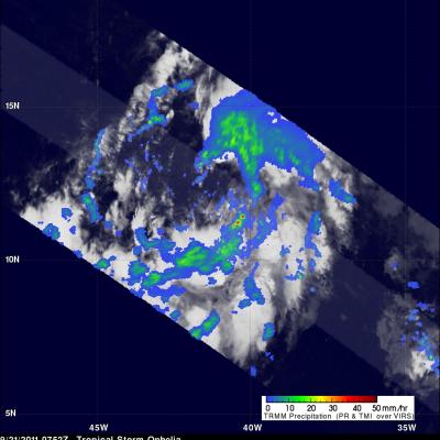
The TRMM satellite passed over newly formed tropical storm Ophelia in the Atlantic Ocean on September 2011 at 0752 UTC ( 4:52 AM EDT). TRMM shows that Ophelia isn't very well organized and contains only a few scattered areas of heavy rainfall. The National Hurricane Center (NHC) has predicted that Ophelia will remain a tropical storm with wind speeds reaching a maximum of 50 kts (~58 mph).