TRMM

Super Typhoon Haiyan Hits the Philippines
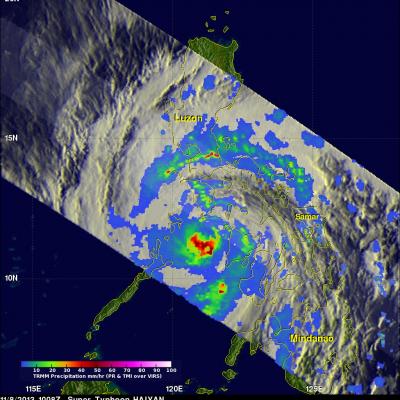
Super typhoon Haiyan, equivalent to a Category 5 hurricane on the US Saffir-Simpson scale, struck the central Philippines municipality of Guiuan at the southern tip of the province of Eastern Samar early Friday morning at 20:45 UTC (4:45 am local time) as an extremely powerful super typhoon, perhaps the strongest ever recorded at landfall, with sustained winds estimated at 195 mph (315 kph) by the Joint Typhoon Warning Center. Previously, Hurricane Camille, which struck the northern Gulf Coast in 1969, held the record with 190 mph sustained winds at landfall. After striking Samar, Haiyan...
NASA satellites used to predict zebra migrations
Of stars and stripes: NASA satellites used to predict zebra migrations One of the world's longest migrations of zebras occurs in the African nation of Botswana, but predicting when and where zebras will move has not been possible until now. Using NASA rain and vegetation data, researchers can track when and where arid lands begin to green, and for the first time anticipate if zebras will make the trek or, if the animals find poor conditions en route, understand why they will turn back. Covering an area of approximately 8,500 square miles (22,000 square kilometers), Botswana’s Okavango Delta is...

NASA Satellites Track Zebra Crossing

Submitted by JacobAdmin on Fri, 08/16/2013
Video Embed
Botswana's Okavango Delta and the Makgadikgadi Salt Pans are two ends of a 360-mile round trip zebra migration, the second longest on Earth. In this animation, shades of red show dry areas, green represents vegetation, and the dots show GPS tracked zebras. The zebras begin at the Okavango Delta in late September. After the dry Southern hemisphere winter, November rains signal it is time to begin their two-week journey to the Salt Pans.
Aerial photo of 2010 landslide in Gansu, China
By Lisa-Natalie Anjozian , NASA Goddard Space Flight Center Original www.nasa.gov Press Release (published 11/27/12) A NASA study using TRMM satellite data revealed that the year 2010 was a particularly bad year for landslides around the world. Around midnight on August 8, 2010, a violent surge of loosened earth roared down mountain slopes and slammed into quietly sleeping neighborhoods in Zhouqu County in Gansu, China. The catastrophic mudslides—the deadliest in decades according to state media—buried some areas under as much as 23 feet (7 meters) of suffocating sludge. 1,765 people died...

2010 Landslide in Gansu, China

Aerial photo of 2010 landslide in Gansu, China
Image Caption
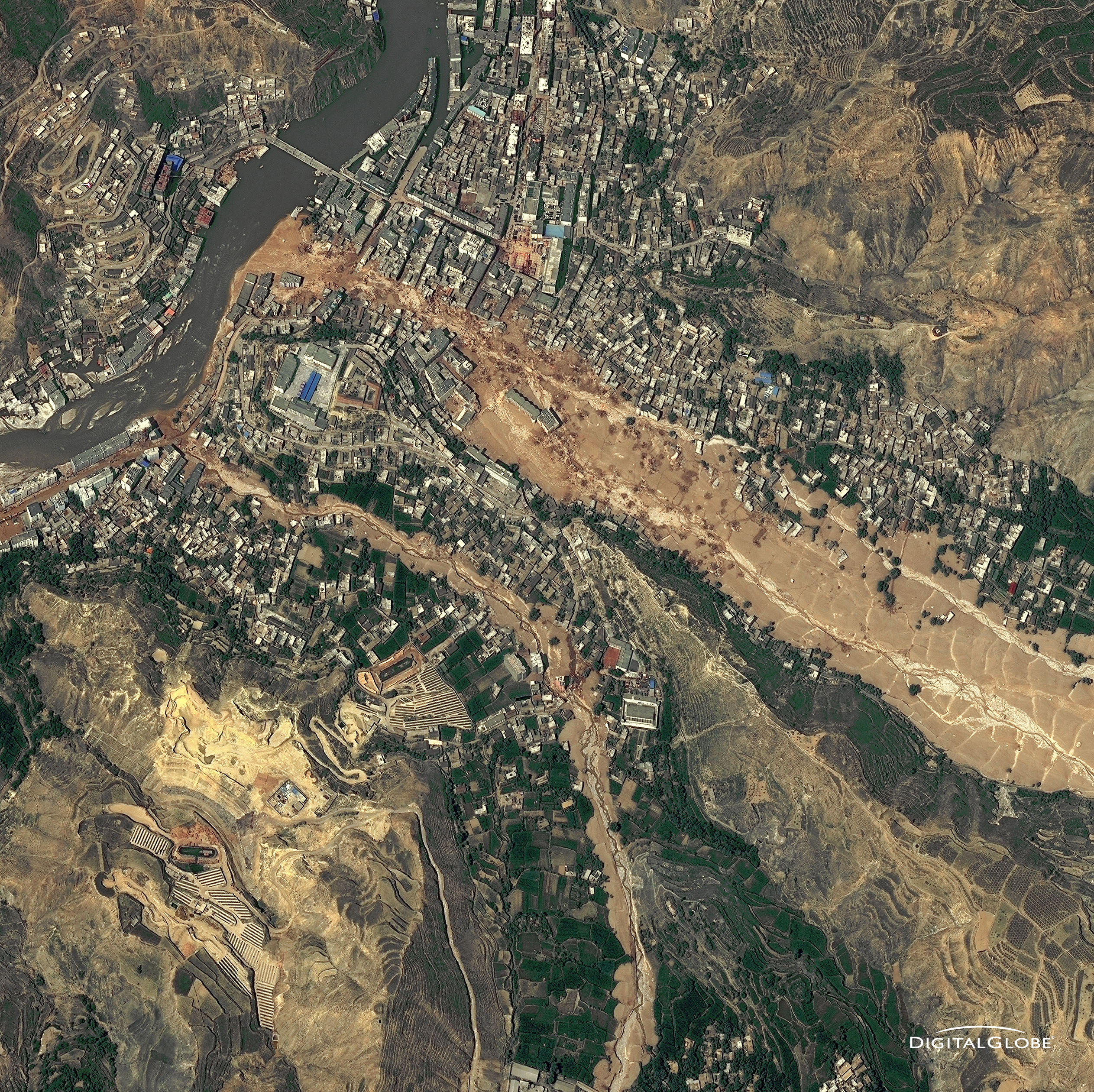
Around midnight on August 8, 2010, a violent surge of loosened earth roared down mountain slopes and slammed into quietly sleeping neighborhoods in Zhouqu County in Gansu, China.

The catastrophic mudslides—the deadliest in decades according to state media—buried some areas under as much as 23 feet (7 meters) of suffocating sludge. 1,765 people died. Property damages totaled an estimated $759 million. Cutting from right to left, this detailed image, from DigitalGlobe’s WorldView-2 satellite, shows the largest slide in the lower part of the city on August 10, 2010.

Image Credit: Digital Globe, DigitalGlobe usage policy

TRMM reign of rain screenshot
By Ellen Gray , NASA Goddard Space Flight Center Original www.nasa.gov Article (published 11/27/12) When it rains it pours, goes the saying, and for the last 15 years, the data on tropical rainfall have poured in. NASA's Tropical Rainfall Measuring Mission (TRMM) was launched on Nov. 27, 1997, and for the last decade and a half has enabled precipitation science that has had far reaching applications across the globe. TRMM Project Scientist Scott Braun looks back at the legacy of the Tropical Rainfall Measuring Mission and a few of the major scientific milestones the satellite has helped...

TRMM at 15: The Reign of Rain

Submitted by JacobAdmin on Tue, 11/27/2012
Video Embed

When it rains it pours, goes the saying, and for the last 15 years, the data on tropical rainfall have poured in. NASA's Tropical Rainfall Measuring Mission (TRMM) was launched on Nov. 27, 1997, and for the last decade and a half has enabled precipitation science that has had far reaching applications across the globe.

Document Description

This excerpt from the March-April 2012 edition of The Earth Observer provides a summary of the activities at the PMM Science Team Meeting which took place from November 7 - 10 2011. The meeting brought together over 150 participants from 10 countries, and included representatives from NASA, JAXA, the National Oceanic and Atmospheric Administration (NOAA), universities, industry, and other international partner agencies.

Scientists Gather in Denver for the 2011 PMM Science Team Meeting

Over 150 scientists from 10 different countries are meeting in Denver, Colorado, to discuss rain and snow and how to measure them from space. Only once a year members of the Precipitation Measurement Missions (PMM) Science Team come together to discuss the science surrounding both the current Tropical Rainfall Measuring Mission (TRMM) and the upcoming Global Precipitation Measurement (GPM) mission that will launch in 2014. The four-day meeting opened on Monday, November 7th with a focus on the mission status for both TRMM and GPM, and continues with breakout sessions, scientific presentations