tropical cyclones

First Images from NASA-JAXA GPM Satellite
On March 10, the Core Observatory passed over an extra-tropical cyclone about 1055 miles (1700 kilometers) due east of Japan's Honshu Island. Satellite data shows the full range of precipitation in the storm. Image Credit: NASA's Goddard Space Flight Center Download related multimedia in HD formats from NASA Goddard's Scientific Visualization Studio NASA and the Japan Aerospace Exploration Agency (JAXA) have released the first images captured by their newest Earth-observing satellite, the Global Precipitation Measurement (GPM) Core Observatory, which launched into space Feb. 27. The images...

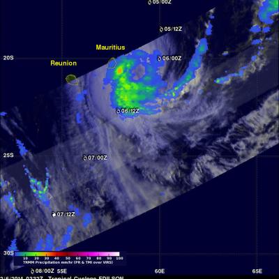
Tropical Cyclone Formation

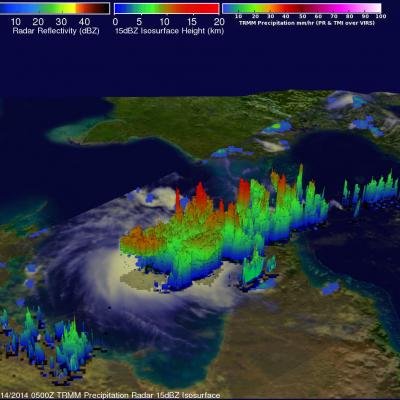
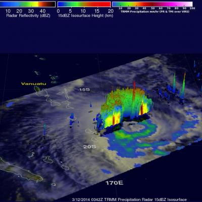
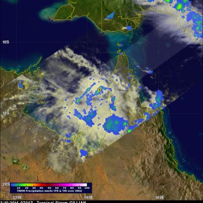
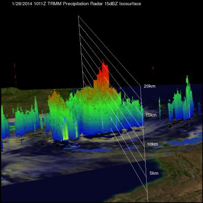
The TRMM satellite flew above northern Australia on March 14, 2014 at 0500 UTC capturing data used in the image on the right. Very strong convective storms in this area are the remnants of tropical cyclone GILLIAN and may signal a rebirth. TRMM's Precipitation Radar (PR) instrument found rain falling at the rate of over 116 mm/hr (~4.5 inches) in these powerful storms in the northeastern Gulf Of Carpentaria. TRMM PR data were also used in this 3-D view of the strong convective storms in the northern Gulf Of Carpentaria. Some towering convective storms were found to be very energetic. Several

Deadly Tropical Cyclone Lusi

Tropical cyclone LUSI recently caused the deaths of at least three people as it moved through the island nation of Vanuatu in the South Pacific Ocean. The TRMM satellite flew above tropical cyclone LUSI on March 12, 2014 at 0342 UTC. A rainfall analysis made from TRMM's Microwave Imager (TMI) and Precipitation Radar (PR) data is shown overlaid on an enhanced visible/infrared image from TRMM's Visible and InfraRed Scanner (VIRS). TRMM PR data revealed with this analysis that rain was falling at a rate of over 97 mm/hr (~3.8 inches) in rain bands rotating around LUSI's center. TRMM's

High Level Of Tropical Cyclone Activity South Of The Equator

Tropical cylone activity has recently increased in the the Southern Hemisphere. On March 10, 2014 the TRMM satellite viewed three tropical storms within two hours. The images above use data received by the TRMM satellite when it flew above tropical storm HADI on March 10, 2014 at 0528 UTC. TRMM found that almost all heavy rainfall with HADI was located in the Coral Sea well off the northeastern coast of Australia. Data from TRMM's Precipitation Radar (PR) instrument were used in the image on the right to show the 3-D structure within the tropical storm. Tropical storm LUSI was located near

Tropical Storm Faxai Forms Southeast Of Guam

A tropical depression that developed southeast of Guam was upgraded to a tropical storm called FAXAI early Saturday morning (local time). The TRMM satellite has had several good looks of the tropical storm during it's formation. As it passed over head on February 27, 2014 at 2357 UTC the satellite had an outstanding daytime view of the developing tropical cyclone . Rainfall data collected by TRMM's Microwave Imager (TMI) and Precipitation Radar (PR) instruments are shown overlaid on enhanced visible and infrared images from TRMM's Visible and InfraRed Scanner (VIRS). TRMM PR data indicated

Tropical Cyclone Guito's Rainfall

The TRMM satellite had a look at tropical cyclone Guito in the Mozambique Channel on February 18, 2014 at 1525 UTC. This early evening view occurred only about three hours after Guito attained tropical storm intensity of 35kts (~40 mph). TRMM's Microwave Imager (TMI) had better coverage of Guito than the Precipitation Radar (PR) instrument whose swath was well to the south of the tropical cyclone's center of circulation. TRMM TMI revealed that Guito was producing rain at a rate of over 50mm/hr (~ 2 inches) in the center of the Mozambique Channel and scattered light rain on Madagascar's western

Tropical Cyclone Fobane

Tropical cyclone Fobane was located southeast of Reunion Island in the southwest Indian Ocean when the TRMM satellite passed over on February 11, 2014 at 0035 UTC. Fobane was very small but contained a few powerful convective thunderstorms near the tropical cyclone's center of circulation. TRMM's Precipitation Radar (PR) measured rain falling at a rate of over 68mm/hr (~2.7 inches) in these storms. The image above shows a simulated 3-D view using data from TRMM's Precipitation Radar (PR) instrument. Those data found a few of the powerful storms near Fobane's center were reaching heights of

Tropical Cyclone Edilson Near Mauritius

Tropical Cyclone Edilson was passing close to the islands of Mauritius and Reunion, in the south Indian Ocean, when the TRMM satellite flew above on February 6, 2014 at 0332 UTC. Rainfall from TRMM's Microwave Imager (TMI) and Precipitation Radar (PR) instruments is shown overlaid on an enhanced visible/infrared image from TRMM's Visible and InfraRed Scanner (VIRS). TRMM TMI data showed that moderate to heavy rain was falling at a rate of over 30mm/hr (about 1.1 inches) just to the southeast of Mauritius. With sustained winds of about 55kts (~63 mph), Edilson is much weaker than deadly

Lecture: Finding Hot Towers in Hurricanes

Submitted by JacobAdmin on Fri, 01/31/2014
Video Embed

Owen Kelley, research scientist at NASA Goddard Space Flight Center,  discusses the science, the technology and the researcher who coined the term "hot tower" 50 years ago. During the past decade, NASA's Tropical Rainfall Measuring Mission satellite has been able to collect definitive statistics on the association of hot towers (towering thunderclouds) and hurricane intensification.

TRMM Sees Potential Tropical Cyclone

The TRMM satellite flew above a tropical low (91S) in the Mozambique Channel on January 28, 2014 at 1011 UTC. TRMM data collected with this pass may be helpful in evaluating this low for possible tropical cyclone formation. An analysis of rainfall from TRMM's Microwave Imager (TMI) and Precipitation Radar (PR) instruments are shown on the left overlaid on a visible/infrared image from TRMM 's Visible and InfraRed Scanner (VIRS). TRMM PR measured rain falling at the rate of over 134.9 mm/hr (about 5.3 inches) in a band of powerful convective thunderstorms north of the center of circulation. A 3