US midwest

Severe Midwest Storms Probed By GPM Satellite

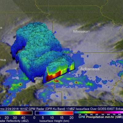
The GPM core observatory satellite flew over stormy weather in the Midwest on Saturday February 24, 2018 at 1610 UTC (10:10 AM CST). Floods and very severe thunderstorms were developing with this slow moving storm complex. Later in the day tornadoes within these storms caused destruction and injuries in the states of Kentucky, Arkansas, Missouri and Tennessee. Tornadoes and flooding were blamed for at least four fatalities. Kentucky was particularly hard hit with Saturday evening tornadoes moving through southwestern Kentucky causing multiple injuries and at least three deaths. GPM's microwave

Heavy Downpours Cause Flooding In The Midwest

Heavy rain has resulted in significant flooding in the Midwest during the past week. Water flowing into the Fox River in northeastern Illinois caused serious flooding in that area. Central Indiana and central Ohio have also had remarkable flooding. NASA's Integrated Multi-satelliE Retrievals for GPM (IMERG) data were used to show estimates of rainfall accumulation in the Midwest during the period from July 7-14, 2017. This analysis indicates that parts of Wisconsin, Illinois, Indiana and Ohio had the highest rainfall totals during the period with over 6 inches (152.4 mm) of rain being seen in

Moisture From Norbert Spreads Heavy Rain Over Southwest

The TRMM satellite flew above the post-tropical cyclone remnants of former hurricane Norbert on September 8, 2014 at 0849 UTC (1:49 AM PDT). This image shows TRMM rainfall derived from the Microwave Imager (TMI) and Precipitation Radar (PR) instruments overlaid on a 0900 UTC GOES-EAST enhanced Infrared image. These data show that only a small amount of light to moderate rainfall was located around Norbert's center of circulation. This view shows that heavy rainfall was being produced over the southwestern United States. This 3-D image was made from TRMM Precipitation Radar (PR) data. It shows

A Week of Violent Weather And Heavy Rainfall

Over the past seven days stormy weather has spawned tornadoes and dropped extremely heavy rainfall in the Northern Plains and the Great Lakes states. This deluge has caused flooding in South Dakota, Minnesota, Iowa, Wisconsin and Illinios. There have been concerns about the Mississippi, Big Sioux and Rock River Rivers escaping their banks. For more than sixteen years rainfall has been monitored by the TRMM-based, near-real time Multi-satellite Precipitation Analysis (TMPA) . These products have been developed at the NASA Goddard Space Flight Center by the precipitation research team. (TMPA)

Heavy Rain & Tornadoes

Tornadoes killed two people yesterday in Pilger, Nebraska. Tornadoes were reported with violent weather that also hit the states of North Dakota, Iowa and Wisconsin. Heavy rainfall with this extreme weather was monitored with the TRMM-based, near-real time Multi-satellite Precipitation Analysis (TMPA) at the NASA Goddard Space Flight Center. An analysis of TMPA rainfall totals is shown here for the seven days from June 10-17, 2014. This analysis indicated that the highest rainfall totals for the period (light purple) were greater than 300 mm (about 11.8 inches) in northwestern Iowa. Locations

Strong Storms Bring Heavy Rain, Flooding to Upper Midwest

An upper-level trough of low-pressure dropping down out of the Canadian Rockies in combination with a persistent frontal boundary and high pressure over the Southeast, combined to bring about strong storms and flooding over the Upper Midwest. The storms brought the worst flooding on record to Duluth, Minnesota where as much as 10 inches of rain were reported over a 2-day period from 19th to the 20th of June, resulting in flash flooding and many washed out roads. Even the zoo was flooded. Washed out roads were blamed for 3 fatalities in nearby Wisconsin. Counter-clockwise flow around high