US Southeast

Tropical Storm Gordon's Rainfall Measured With IMERG

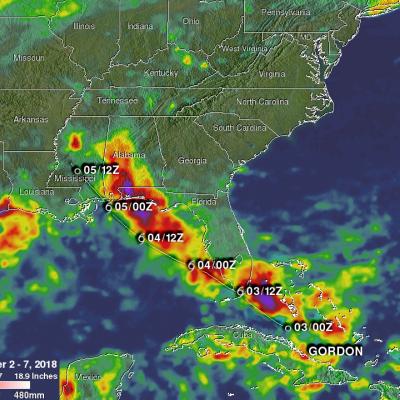
Tropical Storm Gordon became the seventh named system of the 2018 Atlantic hurricane season on Monday September 3, 2018. GORDON became more intense as it moved through the eastern Gulf Of Mexico but didn't quite make it to hurricane force before landfall. GORDON was a strong tropical storm with winds of about 70 mph (~ 61 kts) when it hit southeastern Mississippi on September 5, 2018. GORDON continued to produce rainfall as it moved inland. Weakening GORDON spawned a tornado near Picayune, Mississippi on Thursday September 6, 2018. Today, tropical depression GORDON is still responsible for

Deadly Tornadoes & Flooding Hits The Southeast

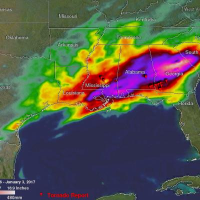
Severe thunderstorms spawned tornadoes and generated flooding rainfall over the Southeast on Monday evening. At least twelve tornadoes were reported with twisters spotted in Mississippi, Alabama and Georgia. Four deaths in Alabama and one in Florida have been blamed on this violent weather. Total rainfall was measured from December 30, 2016 through early January 3, 2017 using precipitation estimates from NASA's Integrated Multi-satelliE Retrievals for GPM (IMERG) data. IMERG data are produced using data from the satellites in the GPM Constellation, and is calibrated with measurements from the

GPM Sees Deadly Tornadic Storms Moving Through The Southeast

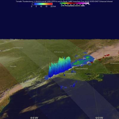
On Tuesday evening through Wednesday morning tornadoes formed along a squall line in advance of a cold front that moved through the Southeast. Over three dozen tornadoes were reported with sightings occurring in Louisiana, Alabama, Mississippi, Tennessee and Alabama. Tornadoes caused the deaths of a least five people in northern Alabama. Storms also took the the lives of two people in Tennessee. This Rainfall may provide some relief to drought ridden eastern Tennessee where destructive wildfires have been occurring. Some storms were accompanied with hail, strong winds and intense showers. Golf

GPM Observes Weakening Tropical Storm Julia

Tropical storm Julia was recently downgraded to a tropical depression. The GPM core observatory satellite had an excellent view of tropical storm Julia on September 14, 2016 at 9:36 PM EDT ( September 15, 2016 0136 UTC). Julia was barely a tropical storm at that time with maximum sustained winds of about 40 mph ( 35 kts). Over the past few days Julia has dropped heavy rain along the Atlantic coastline from northeastern Florida to North Carolina. Some areas have received over 8 inches (203 inches) during the past few days. The GPM satellite measured Julia's rainfall and found that intense

Deadly Tornadoes Hit Southern and Central US

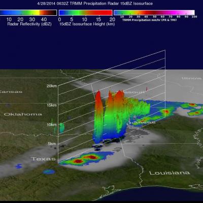
The TRMM satellite flew over the southern United States on April 28, 2014 at 0454 UTC (April 27, at 11:54 CDT) and April 28, 2014 at 0632 UTC (1:32 AM CDT). At both times severe weather pushing through the central and southern United States was observed by the satellite. Tornadoes associated with these areas of powerful thunderstorms killed at least 16 people with 14 deaths reported in Arkansas. Rainfall from TRMM's Microwave Imager (TMI) and Precipitation Radar (PR) instruments is shown above overlaid on GOES-EAST infrared satellite images received at close to the same time. The locations of

TRMM Sees Severe Weather

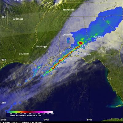
The TRMM satellite flew over the southeastern United States on April 7, 2014 at 1300 UTC (9:00 AM EDT) when a line of intense thunderstorms was moving through the area. Tornado watches were in effect over much of the area. A possible tornado, associated with the same weather system, caused destruction and injuries when it moved through southern Mississippi earlier at about 2 AM EDT. TRMM's Precipitation Radar (PR) data revealed that rain was falling at a rate of over 130mm/hr (about 5.1 inches) in one severe thunderstorm near the Alabama and Florida panhandle border. A radar reflectivity value

Tropical Storm Beryl Brings Some Much Needed Drought Relief to Southeast US

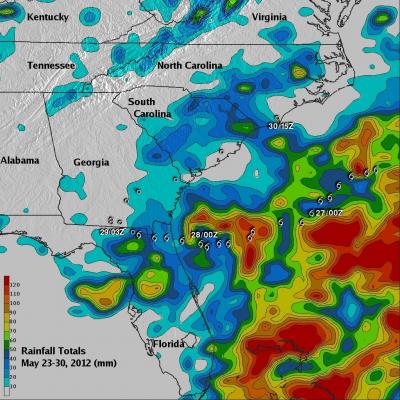
Tropical Storm Beryl was actually a welcome sight in parts of the Southeast. Tropical cyclones are not always bad news. Sometimes they can be quite beneficial, especially when it comes to relieving drought conditions. Tropical Storm Beryl made landfall just after midnight (local time) on the night of 27 May 2012 near Jacksonville Beach, Florida as a strong tropical storm with sustained winds of 70 mph, making it the strongest tropical cyclone to make landfall in the US before the official June 1st start of the Atlantic hurricane season. Prior to the arrival of Beryl, many parts of the