GPM

GPM content

Weaker Typhoon Nangka Threatens Japan

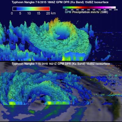
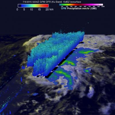
Typhoon Nangka was a super typhoon with winds of 135 kts (155 mph) over the open waters of the Pacific Ocean last week. Nangka is predicted by the Joint Typhoon Warning Center (JTWC) to have weakened to barely typhoon intensity with winds of less than 65 kts ( 75 mph) before hitting Japan on July 16, 2015. The GPM core observatory satellite passed above early in the life of the typhoon on July 6, 2015 when Nangka was east-southeast of Guam. At that time Nangka had formed a nearly perfectly circular eye that contained powerful storms reaching to altitudes of close to 17km (10.5 miles). GPM flew

GPM Looks At Tropical Storm Claudette

The National Hurricane Center (NHC) issued it's first advisory for tropical storm Claudette on Monday July 13, 2015 at 1PM AST. The GPM core observatory satellite had an outstanding view as it flew above tropical storm Claudette on the early evening of July 13, 2015 at 2046 UTC (4:46 PM EDT). Rainfall measurements were made by GPM’s Microwave Imager (GMI) and Dual-Frequency Precipitation Radar (DPR) instruments. Claudette is a relatively small tropical storm with vertical wind shear dampening future development but GPM found heavy rainfall in some strong thunderstorms. GPM's radar instrument

NASA Sees Heavy Rainfall in Tropical Storm Halola

The GPM satellite passed over Tropical Storm Halola in the northwestern Pacific Ocean and found heaviest rainfall occurring north of the center of circulation. Halola formed in the Central Pacific Ocean and moved into the Northwestern Pacific Ocean basin today, July 13. On July 13 at 1500 UTC (11 a.m. EDT) Tropical Storm Halola had maximum sustained winds near 60 knots (69 mph/111.1 kph). It was located near 14.5 North and 177.0 East, about 694 nautical miles (798 miles/1,285 km) east-southeast of Wake Island. Halola has tracked west-northwestward at 11 knots (12.6 mph/20.3 kph). The Global

Tropical Storm Ela To Pass Near Hawaiian Islands

A tropical storm called Ela formed east-southeast of the Hawaiian Islands on July 8, 2015 and is expected to pass to the north of the island chain this weekend. GPM had a good view of Ela as the satellite flew over the forming tropical storm on July 8, 2015 at 1316 UTC (3:16 AM HST). The satellite passed above Ela again on July 9, 2015 at 0234 UTC (July 8, 2015 4:34 PM HST) showing that rainfall bands associated with the tropical cyclone were better organized. GPM's Microwave Imager (GMI) and Dual-Frequency Precipitation Radar (DPR) instruments found today that rainfall was falling at a rate

Two Future Typhoons Monitored By GPM

A chain of tropical cyclones has started forming in the western Pacific Ocean. The GPM core observatory satellite saw two of them this morning. Tropical storm Chan-Hom was seen southeast of Guam by GPM on July 2, 1015 at 0834 UTC. Less than two hours later at 1006 UTC GPM passed over intensifying tropical depression 10W that was located east of the Philippines. Both are expected to become more powerful over the next few days. Typhoon Chan-Hom is predicted by the Joint Typhoon Warning Center (JTWC) to pass just northeast of Guam with winds of over 80 kts (92 mph). TD10W is also predicted to be

GPM Has A Good Look At Tropical Storm Raquel

The GPM core observatory satellite recently had an excellent view of tropical storm Raquel in the South Pacific Ocean. Raquel was moving over the Solomon Islands on July 1, 2015 at 0749 UTC when viewed by GPM. Tropical cyclone activity normally ramps up in the northern hemisphere this time of the year so Raquel's development yesterday north of the Solomon Islands was a little surprising. Rainfall was measured by GPM's Dual-Frequency Precipitation Radar (DPR) and Microwave Imager (GMI) instruments. Those data showed that powerful thunderstorms within Raquel were dropping rain at a rate of over
Using NASA Data to Show How Raindrops Could Save Rupees
Rainwater could save people in India a bucket of money, according to a new study by scientists looking at NASA satellite data. The study, partially funded by NASA’s Precipitation Measurement Missions, found that collecting rainwater for vegetable irrigation could reduce water bills, increase caloric intake and even provide a second source of income for people in India. The study, published in the June issue of Urban Water Journal, is based on precipitation data from the Tropical Rainfall Measuring Mission (TRMM), a joint mission between NASA and the Japan Aerospace Exploration Agency, which...

IMERG Sees Heavy Rain Over United States

During the past week the combination of tropical storm Bill's landfall and a slowly moving frontal system extending from the Midwest to the Northeastern states dropped extreme rainfall from Texas' Gulf coast to the northeastern states. Data from NASA's Integrated Multi-satellitE Retrievals for GPM (IMERG) were used in this analysis to estimate the extreme amount of rain that fell during the past seven days. Tropical Storm Bill and it's remnants caused very heavy rainfall while moving through Texas and Oklahoma. Over a foot of rain was reported in Oklahoma resulting in at least two deaths. The
GPM Sees Tropical Storm Bill Over Texas
Download in hi-res from the NASA Goddard Scientific Visualization Studio Tropical Storm Bill made landfall over Texas at approximately 11:45am CST on June 16, 2015. Shortly after midnight, GPM passed over the storm as it slowly worked it's way northward across the already drenched state of Texas. This visualization shows Bill at precisely 12:11:27am CST (6:11:27 GMT) on June 17, 2015. The GPM Core Observatory carries two instruments that show the location and intensity of rain and snow, which defines a crucial part of the storm structure – and how it will behave. The GPM Microwave Imager sees...