GPM

GPM content

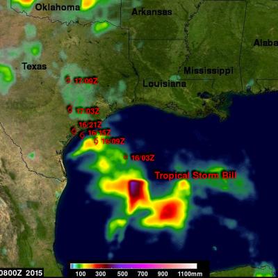
Weakening Tropical Storm Bill Seen By GPM

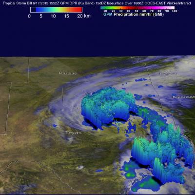
The GPM core observatory satellite had a good daytime look at tropical storm Bill on Wednesday June 17, 1015 at 1552 UTC ( 10:52 AM CDT). GPM saw that an area of heavy rain on Bills northern side was then moving into southern Oklahoma. The Dual-Frequency Precipitation Radar (DPR) on board the satellite measured rain dropping at a rate of over 50 mm (almost 2 inches) per hour in some intense storms. GPM radar data (Ku band) were also used to look at the 3-D structure and storm top heights within storms associated with tropical storm Bill. This image shows that in some areas the dissipating

IMERG Sees Gulf Rainfall With Tropical Storm Bill

Tropical storm Bill became the second named tropical cyclone in the Atlantic Ocean Basin when it formed in the western Gulf Of Mexico on June 16, 2015. Data from the NASA's Integrated Multi-satellitE Retrievals for GPM (IMERG) was used in this analysis to estimate rainfall from Tropical Storm Bill. Precipitation was analyzed from the time when tropical storm Bill was forming in the Gulf Of Mexico on Monday June 15, 2015 until early this morning at 0800 UTC (4 AM CDT). The storm was dropping heavy rainfall over Texas this morning but this analysis indicates that the heaviest rainfall totals, up

Tropical Storm Carlos Viewed By GPM

Tropical storm Carlos is the third tropical cyclone in what promises to be a busy 2015 eastern Pacific hurricane season. The GPM core observatory satellite flew directly above Carlos on June 12, 2015 at 0716 UTC. GPM's Microwave Imager (GMI) and Dual-Frequency Precipitation Radar (DPR) instruments showed that heavy rain was falling in a band of powerful storms to the southeast of the tropical storm's center of circulation. Rainfall was measured by GPM radar (Ku band) falling at a rate of almost 70 mm (2.8 inches) per hour in Carlos' most intense areas of rainfall. Those same radar data were
TRMM Spacecraft Debris to Re-Enter
June 16, 2015, Update: The Tropical Rainfall Measuring Mission (TRMM) spacecraft re-entered the Earth’s atmosphere on June 15, 2015, at 11:55 p.m. EDT, over the South Indian Ocean, according to the U.S. Strategic Command’s Joint Functional Component Command for Space through the Joint Space Operations Center (JSpOC). The U.S. Space Surveillance Network, operated by the Defense Department's JSpOC, had been closely monitoring TRMM’s descent since the mission was ended in April. Most of the spacecraft was expected to burn up in the atmosphere during its uncontrolled re-entry. This U.S. Air Force...

Tropical Cyclone Ashobaa Contains Powerful Storms

The GPM core observatory had another excellent view of tropical cyclone Ashobaa in the Arabian Sea over on June 8, 2015 at 2131 UTC. As expected, Ashobaa was more powerful than when seen by GPM earlier in the day. GPM's Microwave Imager (GMI) and Dual-Frequency Precipitation Radar (DPR) instruments showed that rain was falling at a rate of over 70.5 mm (about 2.8 inches) per hour in bands of storms west of the center of circulation. Very powerful storms were seen west of tropical cyclone Ashobaa's center of circulation by GPM's Ku Band Radar. A 3-D view constructed from GPM's Ku band radar

GPM Flys Over Tropical Cyclone In Arabian Sea

A rare tropical cyclone in the Arabian Sea west of India was seen by the GPM core observatory satellite when it flew over on the morning of June 8, 2015 at 0811Z. Tropical cyclone Ashobaa (TC01A) had sustained wind speeds of about 40 kts (46 mph) when the satellite passed over head. GPM's Microwave Imager (GMI) and Dual-Frequency Precipitation Radar (DPR) instruments measured rain falling at a rate of over 60 mm (2.3 inches) per hour in strong thunderstorms southwest of the storm's center of circulation. A 3-D view was constructed using data from DPR Ku band radar data. This 3-D view of GPM
NASA's Summer Institute for Science Teachers
Maryland teachers will soon embark on NASA’s mission to enhance science learning in elementary schools across the state. During the month of July, educators will study the Chesapeake Bay and surrounding area alongside scientists and engineers who will provide an insider perspective on scientific study. Teachers participate in a previous Global Learning and Observation to Benefit the Environment (GLOBE) program. Credits: NASA/Goddard/Bill Hrybyk This is just one part of NASA’s Summer Watershed Institute, organized by education specialists at NASA’s Goddard Space Flight Center in Greenbelt...

India's Monsoon Starts

Monsoon rainfall, although a little later than normal, has started in southern India. Due to El Nino conditions India's monsoon is predicted to bring below normal rainfall this year. Cooling rainfall comes to the country after high temperatures preceding the monsoon have caused the reported deaths of over 2300 people. Data from the NASA's Integrated Multi-satellitE Retrievals for GPM (IMERG) was used in this animation to show the advent of India's monsoon. Rainfall estimates for the past few days (4-5 June 2015) show that some heavy showers have dropped over 120mm (4.7 inches) of rain in the

Hurricane Blanca Seen Traveling to Baja

After moving very little for the last few days hurricane Blanca has again started to move toward the Baja Peninsula. The GPM core observatory satellite passed directly over Blanca on June 4, 2015 at 2056 UTC when the hurricane had maximum sustained wind speeds of about 85 kts (~98 mph). GPM discovered that Blanca had very little convective rainfall in the center of a large cloudy eye. The satellite's Microwave Imager (GMI) and Dual-Frequency Precipitation Radar (Ku Band) instruments measured rain falling at a rate of over 85mm (3.3 inches) per hour in a band of powerful storms moving around
GPM "Signs of Spring" Photo Contest Winners
This page will automatically redirect you to the GPM "Signs of Spring" winners page. If you are not redirect, please click here.