GPM And TRMM See Glenda At Same Time
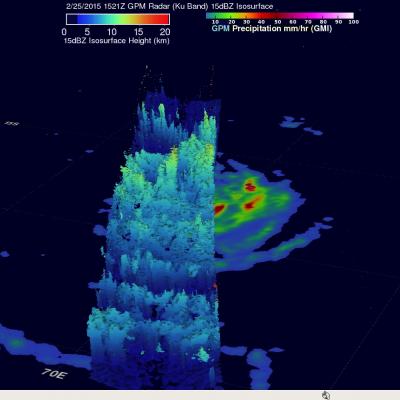
Tropical storm GLENDA formed over the open waters of the South Indian Ocean southeast of Diago Garcia on February 24, 2015. GLENDA didn't get above tropical tropical storm intensity and has not posed a significant threat to islands in the area. An interesting event occurred on February 25, 2015 when both the TRMM satellite and it's successor the GPM core observatory satellite passed over the tropical cyclone at almost the same time. This 3-D view was constructed from GPM Radar data (Ku Band) collected with the 1521 UTC pass. It shows the vertical structure of tropical storm GLENDA along the