GPM

Content which is affiliated solely with the Global Precipitation Measurement Mission.

Strengthening Tropical Storm Ophelia Observed By GPM

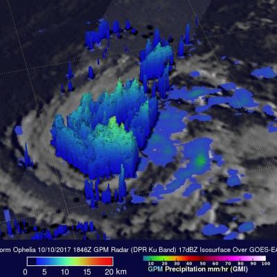
On Monday October 9, 2017 at 1100 AM AST (1500 UTC) tropical depression seventeen (TD17) was upgraded to tropical storm Ophelia. The tropical storm is located over the open waters of the the eastern Atlantic southwest of the Azores. The GPM core observatory satellite had a good view of tropical storm Ophelia on October 10, 2017 at 2:46 PM AST (1846 UTC). GPM's Microwave Imager (GMI) and Dual-Frequency Precipitation Radar (DPR) revealed that the storm was organized but most of the rainfall in the storm was only of light to moderate intensity. The area covered by GPM's 151.9 mile wide (245 km)

GPM Sees Powerful Thunderstorms In Landfalling Hurricane Nate

The GPM core observatory satellite passed above powerful thunderstorms within land falling hurricane Nate on October 8, 2017 at 4:41 AM EDT (0841 UTC). GPM's Dual-Frequency Precipitation Radar (DPR) found that a few storms over southwestern Alabama were dropping rain at the extreme rate of greater than 4 inches (102 mm) per hour. This 3-D slice by GPM's radar (DPR Ku Band) shows the structure of precipitation within the powerful thunderstorms near the center of hurricane Nate. A few thunderstorms over Alabama were found by GPM's radar to have tops reaching heights above 10.5 miles (17 km).

Artifacts in Early and Late IMERG for 9-10 October

Starting with the first orbit of 9 October 2017, the MHS data from NOAA-19 began displaying substantial artifacts. After the orbit crossing 00 UTC 10 October, the NOAA-19 data have been embargoed from Early and Late IMERG, although it took until 03 UTC for all artifacts to age off the morphing. At this point, Early and Late IMERG appear nominal, except they lack the sampling that NOAA-19 provides.

GPM Examines Forming Tropical Storm Nate (TD16)

The GPM core observatory satellite passed above forming tropical storm Nate (TD16) on October 5, 2017 at 5:46 AM EDT (0946 UTC). TD16 was located in the western Caribbean near the coast of Nicaragua with winds of about 34.5 mph (30 kts). Data received by GPM's Microwave Imager (GMI) and Dual-Frequency Precipitation Radar (DPR) shows bands of rain producing heavy rainfall East of TD16's center of circulation. Downpours in the Caribbean Sea East of Nicaragua were measured by GPM's Radar (DPR Ku Band) dropping rain at a rate of over 6.4 inches (162 mm) per hour. This close-up 3-d cross section
Intense Hurricanes Seen From Space
In 2017, we have seen four Atlantic storms rapidly intensify with three of those storms - Hurricane Harvey, Irma and Maria - making landfall. When hurricanes intensify a large amount in a short period, scientists call this process rapid intensification. This is the hardest aspect of a storm to forecast and it can be most critical to people's lives. While any hurricane can threaten lives and cause damage with storm surges, floods, and extreme winds, a rapidly intensifying hurricane can greatly increase these risks while giving populations limited time to prepare and evacuate.

A spatial evaluation of global wildfire-water risks to human and natural systems

Submitted by LisaN on
Publication Year
Authors
Robinne, F.-N., K. D. Bladon, C. Miller, M.-A. Parisien, J. Mathieu, M. D. Flannigan
Journal
Science of the Total Environment
Volume
610-611
Page Numbers
1193-1206
DOI
10.1016/j.scitotenv.2017.08.112
Mission Affiliation
Major Category

GPM Level 1 Constellation Processing will Commence Friday Oct. 06, 2017

With the completion of the TRMM version 8 level 1 processing, PPS will start to process the TRMM era GPM constellation level 1 data on Friday October 6, 2017. Similar to the TRMM version 8 level 1 product, all level 1 constellation products will be produced as GPM version V05, all products are in HDF5 format, all product names will use the GPM naming convention and the produced data will appear both in STORM: https://storm.pps.eosdis.nasa.gov/storm/ and on "arthurhou": ftp://arthurhou.pps.eosdis.nasa.gov/ PPS will reprocess the entire TRMM era constellation data. All users are encouraged to