Date Last Updated
October 2nd, 2020
Document Description

The transition from the Tropical Rainfall Measuring Mission (TRMM) data products to the Global Precipitation Measurement (GPM) mission products has begun. This document specifically addresses the multi-satellite products, the TRMM Multi-satellite Precipitation Analysis (TMPA), the real-time TMPA (TMPA-RT), and the Integrated Multi-satellitE Retrievals for GPM (IMERG).

Hurricane Vance Weakening, Heading Toward Mexico

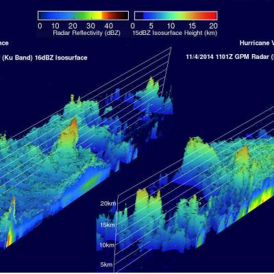
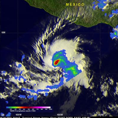
The TRMM satellite flew over hurricane Vance on November 2014 at 0953 UTC. Rainfall derived from TRMM's Microwave Imager (TMI) data collected with that view are shown overlaid on a 1000 UTC GOES-WEST image. This analysis showed that Vance had a large area of heavy rainfall near the center of the hurricane. Some intense storms in that area were dropping rain at a rate of over 50mm/hr (almost 2 inches) per hour. Vance's power peaked late on November 3, 2014 with winds of about 95 kts (about 109 mph). Vertical wind shear had started to weaken the hurricane at the time of this view but Vance was

Tropical Storm Vance Forms

The hurricane season continues to be active in the eastern Pacific Ocean. A Tropical depression south of southern Mexico was upgraded to tropical storm Vance yesterday. The National Hurricane Center (NHC) predicts that Vance will become a hurricane Sunday morning making it the sixteenth hurricane of the 2014 eastern Pacific Ocean hurricane season. TRMM's Microwave imager (TMI) had a good view of the rainfall around tropical storm Vance on October 31, 2014 at 0234 UTC. An analysis of this rainfall is shown overlaid on a 0245 UTC GOES-EAST enhanced infrared image. Intense convective

Tropical Storm Ana Still Vigorous

The TRMM satellite flew over tropical storm ANA on October 22, 2014 at 1935 UTC (about 8:30 AM local time). ANA formed over ten days ago but after moving to the northwest of the Hawaiian islands the tropical storm was shown to be still vigorous. A rainfall analysis from TRMM's Microwave Imager (TMI) revealed an area near ANA's center of circulation where rain was falling at a rate of over 40 mm (about 1.6 inches) per hour. The Joint Typhoon Warning Center (JTWC) predicts that ANA will maintain tropical storm intensity for the next five days while moving over open waters toward the northwest.

Hurricane Ana Bypasses But Soaks Hawaiian Islands

Fortunately for Hawaii hurricane Ana passed to the south of the islands. This meant that for the third time this year the Hawaiian Islands were spared destructive hurricane force winds. However, Ana caused occasionally heavy rain over much of the area and was responsible for flash floods on the the big island (Hawaii). This analysis shows estimated rainfall totals during the period when hurricane Ana formed on October 13, 2014 and moved west of the Hawaiian Islands on October 21, 2014. The TRMM-based, near-real time Multi-satellite Precipitation data (TMPA) analysis is used to monitor rainfall