Category 3 Tropical Cyclone Evan

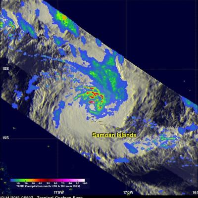
Intensifying tropical cyclone Evan devastated the Samoan Islands when it passed over the islands on December 13, 2012. The TRMM satellite flew directly above Evan today (December 14, 2012) at 0659 UTC when the tropical cyclone was a category 3 on the Saffir-Simpson scale with winds of 100kts (115 mph). TRMM's Microwave Imager (TMI) and Precipitation Radar (PR) data were used in the rainfall analysis on the first image. TRMM's Precipitation Radar (PR) showed that very intense storms in Evan's eye wall were dropping rain at a rate of up to 147mm/hr (~5.8 inches). The strongest radar reflectivity

Freda Brings Heavy Rains to New Caledonia

After forming just south of the Solomon Islands on the evening of December 28th (local time), Cyclone Freda moved southward and intensified, becoming a strong Category 3 cyclone on the 30th. As the storm continued to move south, it weakened significantly and approached the island of New Caledonia on the 2nd of January 2013 as a tropical storm. TRMM captured this image of Freda at 07:16 UTC (6:16 pm local time) 2 January 2013. The image shows an instantaneous snap shot of the rain intensities within Freda. Rain intensities in the center of the swath are from the TRMM Precipitation Radar (PR)

Extreme Rainfall Causes Flooding Over Eastern Australia

A large area of low pressure from the remnants of tropical storm Oswald has caused additional extremely heavy rainfall as it moved southward over eastern Australia. This deluge has caused flooding in areas from the Cape York Peninsula to the Queensland state capital, Brisbane. At least four deaths have been attributed to the high winds and flooding associated with this low pressure system. This image shows a TRMM calibrated Multi-satellite Precipitation Analysis (MPA) for the period from January 21-28, 2013. This analysis shows that tropical cyclone Oswald dumped over 600mm (~23.6 inches) of

Early Spring-like Storm Brings Severe Weather, Tornadoes to the Southeast

Despite it only being the end of January, a large spring-like storm system recently swept through the central and eastern part of the country, bringing a surge of warm air northward over the eastern third of the country and a threat for severe weather over much of the southeast as a strong jet stream dove down out of the Rockies southward to the northern Gulf Coast before racing northward again on the western side of the Appalachians. TRMM captured this image of a long line of strong storms associated with an advancing cold front stretching from southwest Alabama up through the central part of

TRMM Sees Intensifying Winter Storm

At 1257 UTC (7:57 AM EST) this morning the TRMM satellite passed above a rapidly deepening low pressure center over coastal North Carolina. TRMM already saw stormy weather with this low when it was forming yesterday along the Gulf coast. Another area of low pressure moving from the Mid-West is predicted to merge with this storm and result in extreme blizzard conditions over the North-East. Near hurricane force winds and snowfall depths of over 610mm (~24 inches) are predicted in some areas from New York to Boston. An analysis of rainfall from TRMM's Microwave Imager (TMI) and Precipitation