Tropical Cyclone Hellen

Tropical cyclone HELLEN formed in the Mozambique channel northwest of Madagascar on March 28, 2014. HELLEN became a very powerful tropical cyclone with peak sustained winds of 130kts (about 150 mph) on March 30, 2014. HELEN's eye came ashore in northwestern Madagascar On March 31, 2014 with winds predicted to be about 95kts (~109 mph). HELEN is now expected to gradually weaken over northwestern Madagascar while moving southwestward and be over the Mozambique Channel again on April 1, 2014. The TRMM satellite passed above HELLEN on March 30, 2014 at 1747UTC when the tropical cyclone was close

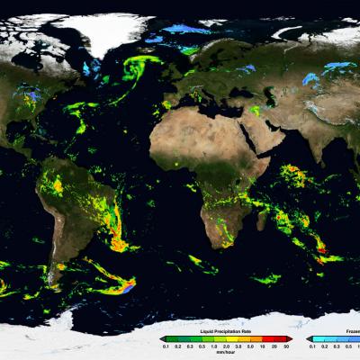
GPM's Stormy New View

Submitted by JacobAdmin on
Video Embed

On March 10, the Core Observatory passed over an extra-tropical cyclone On March 10, the Core Observatory passed over an extra-tropical cyclone about 1055 miles (1700 kilometers) due east of Japan's Honshu Island. Satellite data shows the full range of precipitation in the storm. 

Learn More 

13 Channels of the GMI

13 Channels of GMI
Image Caption
The GMI instrument has 13 channels, each sensitive to different types of precipitation.
The GPM Microwave Imager (GMI) has a swath 550 miles (885 kilometers) wide, giving it a broad view of the extra-tropical cyclone observed off the coast of Japan on March 10, 2014. The GMI instrument has 13 channels, each displayed in this visualization of the data. Each channel is sensitive to a different frequency of microwave energy naturally emitted from or affected by precipitation. As depicted by the graphics, the five channels on the left are sensitive to heavy and moderate rainfall.

First Images from GPM

First Images from GPM
Image Caption
The Dual-frequency Precipitation Radar observes rainfall and snowfall that occurs within clouds in three dimensions, across the surface of the Earth and upward into the atmosphere.
An extra-tropical cyclone was observed over the northwest Pacific Ocean off the coast of Japan on March 10, 2014. 
 
The graph on the left shows the extra-tropical storm seen by the DPR as the satellite passed overhead. The x-axis is the east-west longitude and the y-axis is north-south latitude. The colors show the rain rate at sea-level, with more intense rainfall represented by red and lighter precipitation shown in blue.

First Images from GPM

First Images from GPM
Image Caption
On March 10, the Core Observatory passed over an extra-tropical cyclone about 1055 mi (1700 km) due east of Japan's Honshu Island.

The storm formed from the collision of a cold air mass wrapping around a warm air mass, emerging over the ocean near Okinawa on March 8. It moved northeast over the ocean south of Japan, drawing cold air west-to-east over the land, a typical winter weather pattern that also brought heavy snow over Hokkaido, the northernmost of the four main islands. After the GPM images were taken, the storm continued to move eastward, slowly intensifying before weakening in the central North Pacific. 

Learn More