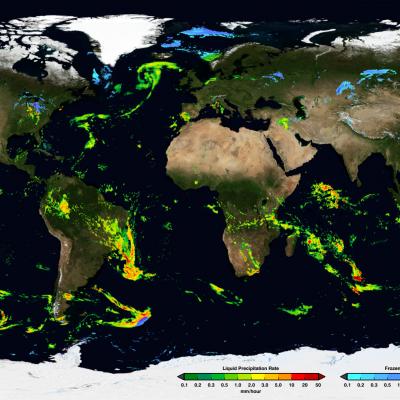
Weakening Tropical Storm Flossie Hits Hawaiian Islands

Weakening tropical storm Flossie had lightning with heavy rain and winds as it drove through the Hawaiian islands. The TRMM satellite flew above tropical depression Flossie on July 30, 2013 at 0717 UTC (July 29, 2013 at 9:17 PM HAST). TRMM's Microwave Imager (TMI) and Precipitation Radar (PR) instruments showed that the heaviest rain at that time was located to the southwest of the Islands and was falling at a rate of over 88mm/hr (3.5 inches). Flossie's approximate locations with appropriate tropical cyclone symbols are shown overlaid in white. TRMM's Precipitation Radar is able to separate

Tropical Storm Flossie Threatens Hawaiian Islands

The TRMM satellite had a very good view of tropical storm Flossie in the eastern Pacific Ocean on July 28, 2013 at 0734 UTC. The image on the left shows an analysis of rainfall data from that pass using TRMM's Microwave Imager (TMI) and Precipitation Radar (PR) instruments. TRMM PR data found rain falling at a rate of over 46 mm/hr (~1.8 inches) in storms just south of Flossie's center of circulation. TRMM PR also found that some of these storms were returning 45dBZ reflectivity values to the satellite indicating that moderate to heavy rain was falling in that area. The map on the right shows

GPM Completes Vibration Tests

The GPM Core satellite successfully completed vibration testing in July 2013, at NASA's Goddard Space Flight Center, Greenbelt, Md. The tests ensure that the spacecraft can withstand the vibrations caused by the Japan Aerospace Exploration Agency (JAXA) H-IIA rocket during satellite’s launch early in 2014. Sitting on a specialized mobile platform, the GPM spacecraft was abruptly moved back and forth in each of its three spatial orientations. GPM attached to the shaker table for horizontal vibration testing. Credit: Warren Shultzaberger / NASA

TRMM Sees Weak Tropical Storm Dorian

The TRMM satellite flew over tropical storm Dorian on July 24, 2013 at 1648 UTC providing data used in this image. Only light to moderate rainfall was found near Dorian's center of circulation by TRMM's Microwave Imager (TMI) and Precipitation Radar (PR) instruments. Precipitation is shown overlaid on a visible/infrared image from TRMM's Visible and InfraRed Scanner (VIRS).