Extreme Weather

Extreme weather news and updates.

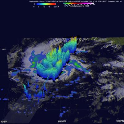
Powerful Hurricane Sandra Viewed By GPM

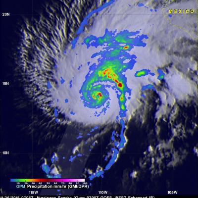
The GPM core observatory satellite flew above hurricane Sandra on November 26, 2015 at 0706 UTC. Sandra had winds of 125 kts (144 mph) at that time making it a category three on the Saffir-Simpson hurricane wind scale. This means that Sandra is the latest major hurricane ever recorded in the eastern Pacific Ocean. Numerous powerful hurricanes were predicted in the eastern Pacific Ocean at the beginning of the hurricane season due to the development of the 2015 El Nino. Data captured by GPM's Microwave Imager (GMI) and Dual-Frequency Precipitation Radar (DPR) instruments shows rain falling at a

Tropical Storm Sandra

Early this morning tropical Storm Sandra became the 18th named storm of the 2015 Eastern Pacific hurricane season. Intensifying tropical storm Sandra had winds of about 35 kts (40 mph) when the GPM core observatory satellite passed over on November 24, 2015 at 0719 UTC. A rainfall analysis derived using data collected at that time by from GPM's Microwave Imager (GMI) and Dual-Frequency Precipitation Radar (DPR) instruments is shown. DPR discovered that the intense convective storms south of the tropical storm's center of circulation were dropping rain at a rate of over 80 mm (3.1 inches) per

Typhoon IN-FA's Extreme Rainfall Measured By GPM

Typhoon IN-FA's peaked as a category four tropical cyclone on the Saffir-Simpson scale with maximum sustained winds of about 115 kts (132 mph) on November 21, 2015. IN-FA's winds had decreased to about 90 kts (103.5 mph) when the GPM core observatory satellite flew over on November 23, 2015 at 1555 UTC. Measurements by GPM's Dual-Frequency Precipitation Radar (DPR) instrument indicated that IN-FA was dropping rain at an extreme rate of over 266 mm (10.5 inches) per hour in storms just to the northwest of the typhoon's eye. GPM's radar (DPR Ku Band) were used to show the 3-D structure of

Tropical Storm Rick Examined By GPM

Tropical storm Rick is the latest tropical cyclone to form in the 2015 Eastern Pacific Ocean hurricane season which has spawned a record number of dangerous hurricanes. Tropical storm Rick was moving over the eastern Pacific Ocean well off the Mexican coast when the GPM core Observatory satellite flew over on November 19, 2015 at 1956 UTC. Data captured by GPM's Microwave Imager (GMI) and Dual-Frequency Precipitation Radar (DPR) show that tropical storm Rick had a couple areas near the center of circulation that were dropping rain at a rate of over 41.6 mm (1.6 inches) per hour. GPM's radar

GPM Sees Better Organized Typhoon IN-FA

The GPM core observatory satellite had another excellent view of typhoon IN-FA on November 19, 2015 at 0305 UTC. This GPM pass revealed the location of typhoon IN-FA's eye beneath dense overcast. Rainfall derived from data collected by GPM's Microwave Imager (GMI) and Dual-Frequency Precipitation Radar (DPR) instruments show that feeder bands around IN-FA were getting better organized. The most intense precipitation was measured in IN-FA's eye wall by DPR where it was falling at a rate of almost 55 mm (2.16 inches) per hour. Most rainfall in feeder bands was shown by GPM to be only light to

GPM Monitors Western Pacific Typhoon IN-FA

On November 18, 2015 at 1533 the GPM core observatory satellite flew directly over a recently formed typhoon called IN-FA that was located near the Equator well to the southeast of Guam. Favorable environmental conditions such as low vertical wind shear and warm sea surface temperatures helped typhoon IN-FA intensify quickly from a tropical depression on November 17 to a typhoon on November 18, 2015. Rainfall from GPM's Microwave Imager (GMI) and Dual-Frequency Precipitation Radar (DPR) instruments were used to analyze the rainfall around typhoon IN-FA. GPM's DPR found that rain was falling at

India's Deadly Flooding Rains Measured By IMERG

During the past week extreme rainfall from two unnamed slow moving tropical lows has causing severe flooding in southern India. This flooding has caused the reported deaths of as many as 71 people. The city of Chennai in the state of Tamil Nadu has been hit exceptionally hard with 59 people people killed. NASA's Integrated Multi-satellite Retrievals for GPM (IMERG) combines all data from 12 satellites into a global map of rainfall at half hourly intervals. The rainfall accumulation analysis above was computed from data generated by IMERG during the past week from November 9-16, 2015. An

Tropical Storm Kate Examined By GPM

Kate became the twelfth named tropical cyclone of the of the 2015 Atlantic hurricane season when it formed near the southeastern Bahamas on Sunday November 8, 2015. Kate re-curved toward the northeast and moved harmlessly over the open waters of the Atlantic. Kate's intensity peaked on November 11, 2015 with winds of about 65 kts making it a category one hurricane on the Saffir-Simpson Hurricane. The GPM core observatory satellite flew above Kate on November 11, 2015 at 0926 UTC (4:26 AM EST) capturing data used in these images. Kate's maximum sustained winds were estimated at about 60 kts (69

Yemen Hit by 2nd Tropical Cyclone in a Week

One week ago to the day Cyclone Chapala, the first Category 1 cyclone to strike Yemen in recorded history made landfall on the south-central coast of Yemen, bringing over a year's worth of rain and flooding to that part of the arid country. Today, yet another tropical cyclone, Megh, made landfall in Yemen. Megh, however, made landfall just to the northeast of the coastal city of Aden, which is further west than where Chapala made landfall, and only as a tropical storm. There are, however, several similarities between the two storms. Megh formed in almost the exact same spot in the central

GPM Sees Another Tropical Cyclone Forming

Another tropical cyclone was caught forming by the GPM core Observatory satellite on November 4, 2015 at 1255 UTC. Deadly tropical cyclone Chapala had just dissipated over Yemen when tropical cyclone 05A started forming in the warm waters of the Arabian Sea west of India. GPM measured the rainfall within the forming tropical cyclone using the satellite's Microwave Imager (GMI) and Dual-Frequency Precipitation Radar (DPR) instruments. GMI and DPR found that 05A had scattered light to moderate rainfall falling at a maximum rate of only 23.3 mm (.92 inches) per hour. The Joint Typhoon Warning