Extreme Weather

Extreme weather news and updates.

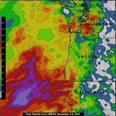
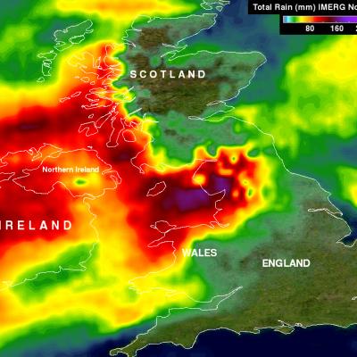
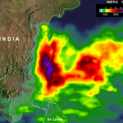
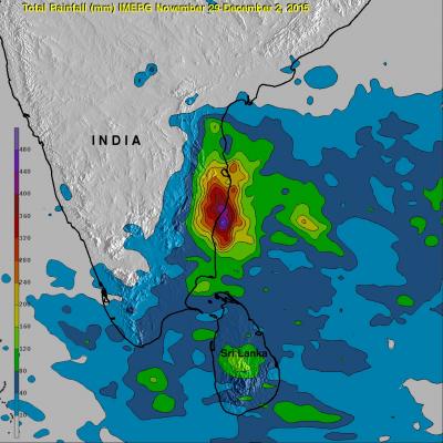
Paraguay's Deadly Flooding Rainfall Measured By IMERG

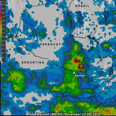
Widespread flooding has recently affected tens of thousands of people in South America. Paraguay has been especially hard hit with the worst flooding in decades occurring after heavy summer rainfall. An estimated 90,000 people have been evacuated from their homes. Storms and flooding caused the deaths of at least six people in Asuncion, Paraguay. The analysis above was generated using the Integrated Multi-satellitE Retrievals for GPM (IMERG) data product. IMERG rainfall estimates are computed in near-realtime. IMERG data indicates that over 350 mm (13.8 inches) of rain fell northeast of

NASA Looks At Deadly Weather Over the US

Heavy rainfall, flooding and tornado outbreaks affected areas of the United States from the Southwest through the Midwest from December 23-27, 2015. Tornadoes and flooding events killed at least 43 people during this period. Fourteen deaths alone occurred with tornadoes that hit Benton, Mississippi on December 23, 2015. Tornadoes are expected in the springtime but are much less frequent during this time of the year. An analysis was made of the rainfall that occurred during the period from December 21-28, 2015. This analysis used data generated by NASA's Integrated Multi-satellitE Retrievals

Typhoon Melor Rainfall Measured By IMERG

Since landfall typhoon Melor has destroyed thousands of homes and caused the deaths of at least six people in the Philippines. Melor had hurricane force during most of the time it spent moving through the central Philippines and weakened to tropical storm intensity only after moving into the South China west of the Luzon. Heavy rainfall from the typhoon also caused some flooding along it's path. An analysis of typhoon Melor's rainfall was made using data from NASA's Integrated Multi-satellitE Retrievals for GPM (IMERG). Total rainfall in the area of typhoon Melor from December 12-16, 2015 is

GPM Sees Super Typhoon Melor Hitting The Philippines

Super typhoon Melor (known in the Philippines as Nona) formed east of the Philippines on December 12, 2015. Melor became more powerful and became a typhoon the next day while heading toward the Philippines. The Joint Typhoon Warning Center (JTWC) indicated that Melor was a super typhoon with winds of 115 kts 115 kts (133 mph) just before hitting the Philippines .The GPM core observatory satellite passed above as super typhoon Melor was impacting the Philippines on December 14, 2015 at 1006 UTC. At that time Melor still had maximum sustained winds of about 115 kts (133 mph). Rainfall derived

Tropical Cyclone 05S Viewed By GPM

Tropical cyclone 05S formed today in the South Indian Ocean well to the northeast of the islands of Reunion and Mauritius. The GPM core observatory satellite had a perfect view of 05S when the satellite flew over on December 9, 2015 at 1416 UTC. At that time the forming tropical cyclone had sustained winds estimated at 35 kts (40 mph). GPM found that 05S was dropping rain at a rate of over 77 mm (~ 3 inches) per hour in strong convective storms near the tropical cyclone's center of circulation. GPM also saw intense rainfall in a strong feeder band that was converging into the storm's

Northwest's Extreme Rainfall Checked By IMERG

During the past week moisture from the tropics has been pumped into the Pacific Northwest by the "Pineapple Express". Resulting extreme rainfall has led to widespread flooding and landslides. The continued "training" of rainfall into the area has caused flooding in the Portland, Oregon area with at least one death reported. Western Washington is also on flood alert due to the deluge. Rainfall that occurred during the past week (December 2-9, 2015) was measured with data from NASA's Integrated Multi-satellitE Retrievals for GPM (IMERG). IMERG found that many areas from northern California

IMERG Measures Flooding Rainfall In Northwest England

In addition to destructive winds measured at 81 mph (70 kts) a powerful winter storm called Desmond dropped record rainfall in northwest England over the past weekend. Desmond's unusually heavy rainfall resulted in wide spread damaging floods. Data from NASA's Integrated Multi-satellitE Retrievals for GPM (IMERG) were used to estimate rainfall for the period from November 30 to December 7, 2015. This analysis found that some rainfall near the Irish Sea measured over 392 mm (~15.4 inches) during this period. As much as 304 mm (~12 inches) of rain were reported to have fallen in only 24 hours

NASA's IMERG Adds Up More of Southern India's Extreme Rainfall

Data from the Global Precipitation Measurement or GPM mission core satellite were used to help estimate rainfall data. GPM is a satellite co-managed by both NASA and the Japan Aerospace Exploration Agency. The city of Chennai on India's southeastern coast was hit particularly hard. More than 260 deaths have been reported in the Indian state of Tamil Nadu. Data from NASA's Integrated Multi-satellitE Retrievals for GPM (IMERG) were used to estimate the flooding rainfall that fell from November 28 to Dec. 4, 2015. Over 400 mm (15.7 inches) of rainfall were estimated over areas south of Chennai

Southern India's Catastrophic Flooding Analyzed By IMERG

Extremely heavy rainfall over southeastern India caused deadly flooding in the middle of the month of November. Record setting rainfall has again caused deadly flooding in southern India. The latest deluge started at the end of November 2015 and generated flooding that has resulted in the reported deaths of 188 people. NASA's Integrated Multi-satellite Retrievals for GPM (IMERG) combines all data from 12 satellites into a continuously updated global map of rainfall at half hourly intervals. The rainfall accumulation analysis above was computed from data generated by IMERG during the period

NASA IMERG Data Measures Hurricane Sandra's Rainfall

Data from NASA's Integrated Multi-satellitE Retrievals for GPM (IMERG) were used to estimate the amount of rainfall that hurricane Sandra produced during the period from November 23-29, 2015. Sandra remained well off the Mexican coast during the most dangerous period from November 25-27, 2015 when Sandra was a powerful hurricane with sustained winds of up to 130 kts (150 mph). This analysis shows that much of Sandra's rainfall occurred over the open waters of the Eastern Pacific. This analysis indicates that moisture flowing from hurricane Sandra also caused heavy rainfall totals of over 700