Extreme Weather

Extreme weather news and updates.

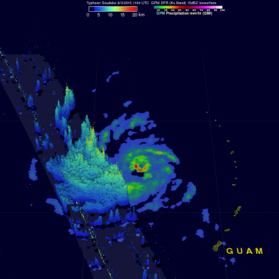
GPM Views Rare Southern Hemisphere Tropical Cyclone

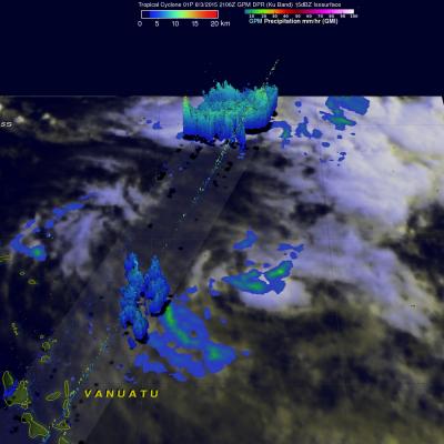
It is a little unusual to see a tropical cyclone forming in the southern Pacific Ocean this time of the year but tropical cyclone 01P formed northeast of Vanuatu recently. The GPM core observatory satellite saw Tropical Cyclone 01P on Monday August 3, 2015 at 2106Z (about 9:06 local time). GPM's Microwave Imager (GMI) found rain falling at a rate of over 30 mm (1.2 inches) per hour in a small area of showers near the center of the tropical cyclone. A 3-D view constructed from GPM's Dual-Frequency Precipitation Radar (DPR) instrument (Ku band) showed that some showers located between the

Super Typhoon Soudelor Threatens Taiwan And China

The GPM core observatory satellite flew almost directly over super typhoon Soudelor in the western Pacific Ocean on August 3, 2015 at 1104 UTC. At that time Super Typhoon Soudelor had winds of about 125kts (139 mph) and is predicted by the Joint Typhoon Warning Center (JTWC) to become even more powerful tomorrow while headed toward northern Taiwan. GPM's Microwave Imager (GMI) had a very good view of heavy rainfall associated with Soudelor. GMI showed that the super typhoon had rain falling at a rate of over 58 mm (2.3 inches) per hour in the southern side of Soudelor's well defined eye. Radar

Weakening Hurricane Guillermo Nears Hawaiian Islands

Hurricane Guillermo was a category one hurricane with wind speeds of about 75 kts (86 mph) when the GPM core observatory satellite flew over on Sunday August 2, 2015 at 1901 UTC. Rainfall was measured by GPM's Microwave Imager (GMI) and Dual-Frequency Precipitation Radar (DPR) instruments falling at a rate of over 61 mm (2.4 inches) per hour northeast of Guillermo's eye. GPM's DPR found rain falling at a rate of over 91 mm (3.6 inches) per hour in a feeder band spiraling into Guillermo from the southeast. GPM radar reflectivity data (Ku band) were used to show a 3-D cross section through the

Hurricane Guillermo Heads Toward Hawaii

On July 29, 2015 tropical depression Nine-E formed in the eastern Pacific Ocean well southwest of the southern tip of Baja California. The tropical depression was in an area of warm ocean water which helped the tropical cyclone blossom into tropical storm Guillermo early on July 30, 2015. Guillermo is a hurricane today and is headed over the open waters of the Pacific Ocean toward the west-northwest. In about a week Guillermo may affect the Hawaiian Islands as a tropical storm. On July 31, 2015 at 0556 UTC Guillermo was about 319 km (~590 Nautical Miles) east-southeast of Hilo, Hawaii when the

GPM Sees Tropical Cyclone Drenching Bangladesh

Bangladesh was already soaked by monsoon rainfall before recently formed tropical storm Komen started drenching the area. The GPM core observatory satellite collected data above the tropical cyclone on on July 30, 2015 at 0436 UTC ( 10:36 AM BDT). GPM's Microwave Imager (GMI) measured rain falling at the extreme rate of close to 150 mm (5.9 inches) per hour in powerful storms over the Bay Of Bengal. A 3-D view of thunderstorm tops based on radar reflectivity day from GPM's Dual-Frequency Precipitation Radar (DPR) is shown here. DPR (Ku band) radar data were used in this simulated cross section

TD08E Formation Monitored By GPM

The GPM core observatory satellite flew over forming tropical depression 08E on July 27, 2015 at 1931 UTC ( 12:31 PM PDT). Rainfall was measured by GPM's Microwave Imager (GMI) and Dual-Frequency Precipitation Radar (DPR) falling at a rate of 50 mm (almost 2 inches) per hour in storms near the center of the tropical depression. The National Hurricane Center (NHC) predicts that TD08E will not intensify very much because northwesterly vertical wind shear is retarding development. GPM's DPR instrument scan (shown in lighter shades) viewed an area east of the center of the developing tropical

Typhoon Halola Threatening Japan

Typhoon Halola is predicted by the Joint Typhoon Warning Center (JTWC) to weaken to tropical storm intensity over the next couple days while passing to the north of Okinawa, Japan. Recent predictions of Halola's track are shown overlaid in red. The GPM core observatory's Microwave Imager (GMI) and Dual-Frequency Precipitation Radar (DPR) measured rainfall as it flew directly over typhoon Halola in the western Pacific Ocean on July 23, 2015 at 1414 UTC. A simulated 3-D flyby around typhoon Halola was made from GPM Radar data (Ku Band). This animation shows that that Halola's eye wall was

GPM Sees Halola Becoming A Typhoon

Satellite technology has the ability to see things we could never imagine, like how hard the rain is falling in storms, and how high cloud tops stretch into the atmosphere. The Global Precipitation Measurement (GPM) core observatory satellite does both of those things and has been providing that information each time it passes over Typhoon Halola in the Northwestern Pacific Ocean. The GPM core observatory is a joint effort between NASA and the Japan Aerospace Exploration Agency. GPM saw Halola when it was strengthening from a tropical storm into a typhoon. GPM flew over Tropical Storm Halola

IMERG Measures Record Rainfall From Hurricane Delores Remnants

Moisture pumping into southern California and the Desert Southwest from the remnants of hurricane Dolores has caused record July rainfall. This rainfall may provide some drought relief to the state of California that has been in the grip of exceptional drought conditions. Heavy flooding caused an interstate 10 bridge collapse on Sunday July 19, 2015 forcing closure of this main roadway between Southern California and Phoenix, Arizona. Data from NASA's Integrated Multi-satellitE Retrievals for GPM (IMERG) were used to estimate the extreme amount of rain that fell during the past week in that

Weaker Typhoon Nangka Threatens Japan

Typhoon Nangka was a super typhoon with winds of 135 kts (155 mph) over the open waters of the Pacific Ocean last week. Nangka is predicted by the Joint Typhoon Warning Center (JTWC) to have weakened to barely typhoon intensity with winds of less than 65 kts ( 75 mph) before hitting Japan on July 16, 2015. The GPM core observatory satellite passed above early in the life of the typhoon on July 6, 2015 when Nangka was east-southeast of Guam. At that time Nangka had formed a nearly perfectly circular eye that contained powerful storms reaching to altitudes of close to 17km (10.5 miles). GPM flew