Extreme Weather

Extreme weather news and updates.

Tropical Storm Danny Forms in the Atlantic

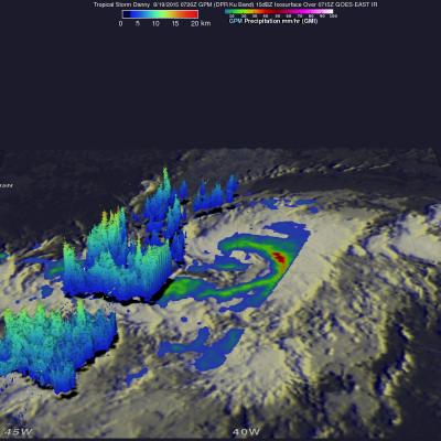
Tropical Storm Danny became the 4th named storm of the season yesterday afternoon when it formed in the central Atlantic about 1660 miles east of the Windward Islands. Danny originated from an African easterly wave that moved off of the coast of Africa 4 days earlier on the 14th of August. Storms that form in this region are known as Cape Verde storms and typically form towards the height of hurricane season. In a typical season, there are about 10 named storms and 6 hurricanes. With this year being a potentially strong El Nino year, Atlantic hurricanes are usually suppressed. However, it only

Intensifying Atsani Viewed By GPM

Atsani is a typhoon today but was an intensifying tropical storm moving over the open waters of the Pacific Ocean on August 16, 2015 when the GPM core observatory satellite flew above at 0601 UTC. An analysis of precipitation derived from GPM's Microwave Imager (GMI) and Dual-Frequency Precipitation Radar (DPR) instruments is shown overlaid on a 0600 UTC MTSAT-2 visible infrared image. This analysis revealed that very heavy rain that was located south of the storm's center of circulation. Rain there was found to be falling at a rate of over 90 mm (3.5 inches) per hour. A simulated 3-D view of

Another Typhoon Headed Toward Taiwan And China

Last week deadly typhoon Soudelor caused at least 22 deaths in Taiwan and China. The GPM core observatory satellite recently had two good views of intensifying typhoon Goni that formed on August 14, 2015 in the same area of the Pacific Ocean as typhoon Soudelor. Typhoon Goni is forecast by the Joint Typhoon Warning Center (JTWC) to become a very powerful typhoon in the next week while moving along a track similar to typhoon Soudelor. Typhoon Goni could affect the same areas of the western Pacific Ocean. The first image shows a GPM satellite pass over Goni when the tropical cyclone was moving

GPM Says Goodbye to Tropical Storm Molave

Tropical storm Molave became the 16th named tropical cyclone when it formed on August 7, 2015 and spent the past week over the open waters of the Pacific Ocean. For a few days Molave moved toward Japan but re-curved toward the northeast and passed well to the southeast of Japan. Molave became an extratropical cyclone and the Joint Typhoon Warning Center (JTWC) issued it's last warning on August 13, 2015 at 2100 UTC. Molave was last seen as a tropical storm by the GPM core observatory satellite on August 13, 2015 at 2026 UTC. Molave's rainfall intensity was measured with this satellite pass by

Hurricane Hilda Weakening, Heads Toward Hawaii

Three days ago Hilda was a category four hurricane on the Saffir-Simpson Hurricane Wind Scale with winds of 120 kts (138 mph). Hilda has been weakening and had winds of about 80 kts (92 mph) when the GPM core observatory satellite passed above on August 11, 2015 at 0411 UTC (August 10, 2015 at 6:11 PM HST). Rainfall data from GPM's Microwave Imager (GMI) instrument is shown overlaid on a 0400 UTC August 11, 2015 GOES-WEST Infrared image. GPM's GMI revealed that storms north of hurricane Hilda's eye were dropping rain at a rate of over 53.6 mm (2.2 inches) per hour. Hilda's future positions

Deadly Typhoon Soudelor's Rainfall Analyzed

Soudelor formed in the middle of the Pacific Ocean well east of Guam on July 20, 2015. Soudelor became more powerful with peak intensity of about 155 kts (178 mph) reached on August 3, 2015 when the super typhoon was well east of Taiwan over the open waters of the Pacific Ocean. Soudelor's winds died down a little but rebounded to with over 100 kts (115 mph) before hitting Taiwan . Although Soudler was still a powerful typhoon when it hit land most deaths and destruction were caused by flooding and mudslides from heavy rainfall not from strong winds. The rugged terrain over typhoon amplified

GPM Sees Typhoon Soudelor On Taiwan's Doorstep

The GPM core observatory satellite continued to provide excellent coverage of Soudelor as the typhoon closed in on Taiwan. GPM flew directly above typhoon Soudelor's eye on August 7, 2015 at 1041Z (6:41 PM Local Time) when wind speeds were 110 kts (127 mph). Rainfall data from GPM's Microwave Imager (GMI) and Dual-Frequency Precipitation Radar (DPR) instruments revealed very heavy rainfall in spiraling bands rotating around a decaying inner eye wall. Precipitation intensity can be measured by the Dual-Frequency Precipitation Radar instrument mounted on the GPM core observatory satellite. Some

GPM Has Another Good Look At Soudelor

Typhoon Soudelor's winds had dropped to 95 kts ( 109 mph) when the GPM core observatory satellite had another excellent daytime view on August 6, 2015 at 0006 UTC. GPM's Dual-Frequency Precipitation Radar (DPR) data showed that Soudelor had heavy rainfall in an inner eye wall and also in a much larger replacement outer eye wall. The heaviest rain found by GPM was dropping at a rate of close to 70 mm (2.4 inches) per hour in a strong feeder band spiraling in on the southwestern side of the typhoon. Radar reflectivity data from GPM's Dual-Frequency Precipitation Radar (DPR) data were also used

Typhoon Soudelor Threatens Taiwan And China

Typhoon Soudelor's sustained winds were about 105 kts ( about 121 mph) when the GPM core observatory satellite flew above on August 5, 2015 at 1051 UTC. A rainfall analysis was made from data collected from GPM's Microwave Imager (GMI) and Dual-Frequency Precipitation Radar (DPR) instruments. This analysis showed that Soudelor was very large and had a well defined eye. Intense feeder bands are shown spiraling into the center. Three dimensional radar reflectivity data GPM's DPR (ku Band) were used to construct a simulated cross section through typhoon Soudelor's center. This view from the south

GPM Views Rare Southern Hemisphere Tropical Cyclone

It is a little unusual to see a tropical cyclone forming in the southern Pacific Ocean this time of the year but tropical cyclone 01P formed northeast of Vanuatu recently. The GPM core observatory satellite saw Tropical Cyclone 01P on Monday August 3, 2015 at 2106Z (about 9:06 local time). GPM's Microwave Imager (GMI) found rain falling at a rate of over 30 mm (1.2 inches) per hour in a small area of showers near the center of the tropical cyclone. A 3-D view constructed from GPM's Dual-Frequency Precipitation Radar (DPR) instrument (Ku band) showed that some showers located between the