Fantala

Tropical Cyclone Fantala's Changes Observed By GPM

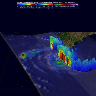
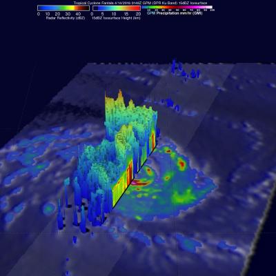
As expected, tropical cyclone Fantala reversed course and moved southeastward almost directly over it's earlier track. The tropical cyclone's intensity also fluctuated. Maximum winds dropped significantly as Fantala moved southeastward but have rebounded somewhat today. The GPM core observatory satellite flew over the tropical cyclone on April 19, 2016 at 1346Z when winds had dropped to about 95 kts (109 mph). At that time GPM's Microwave Imager (GMI) and Dual-Frequency Precipitation Radar (DPR) found that Fantala still contained extremely heavy rainfall in storms spiraling into the tropical

GPM Views Increasingly Powerful Tropical Cyclone Fantala

Tropical cyclone Fantala has continued to intensify while moving westward over the open waters of the South Indian Ocean. The GPM core observatory satellite passed directly over Fantala's eye on April 14, 2016 at 0148 UTC. At that time the tropical cyclone had maximum sustained winds estimated at 90 kts (104 mph) making in the equivalent of a category two tropical cyclone on the Saffir-Simpson hurricane wind scale. GPM's Microwave Imager (GMI) and Dual-Frequency Precipitation Radar (DPR) instruments again captured data that were used to estimate rainfall within Fantala. Rain was measured by

Tropical Cyclone Fantala Formation Seen By GPM

A tropical cyclone called Fantala formed in the South Indian Ocean far to the east of Madagascar on on April 11, 2016. Fantala has slowly intensified while moving westward and is expected become even more powerful. The GPM core observatory satellite flew over Fantala (TC19S) on April 10, 2016 at 0206 UTC when the tropical cyclone was forming. The first image shows a rainfall analysis using data captured with by GPM's Microwave Imager (GMI) and Dual-Frequency Precipitation Radar (DPR) instruments. GPM rainfall is shown overlaid on a 0200Z METEOSAT-7 Visible and Infrared image. Intense