Irma

Intense Hurricanes Seen From Space
In 2017, we have seen four Atlantic storms rapidly intensify with three of those storms - Hurricane Harvey, Irma and Maria - making landfall. When hurricanes intensify a large amount in a short period, scientists call this process rapid intensification. This is the hardest aspect of a storm to forecast and it can be most critical to people's lives. While any hurricane can threaten lives and cause damage with storm surges, floods, and extreme winds, a rapidly intensifying hurricane can greatly increase these risks while giving populations limited time to prepare and evacuate.
GPM Examines Hurricane Irma
The GPM core observatory satellite had an exceptional view of hurricane Irma's eye when it flew above it on September 5, 2017 at 12:52 PM AST (1652 UTC). This visualization shows a rainfall analysis that was derived from GPM's Microwave Imager (GMI) and Dual-Frequency Precipitation Radar (DPR) data. Irma was approaching the Leeward Islands with maximum sustained winds of about 178 mph (155 kts). This made Irma a dangerous category five hurricane on the Saffir-Simpson hurricane wind scale. Intense rainfall is shown within Irma's nearly circular eye. This 3-D cross-section through Irma's eye was...

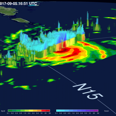
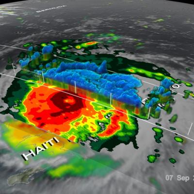
Irma’s Heavy Rainfall Measured With GPM IMERG

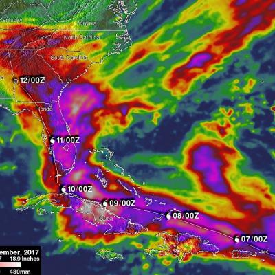
Hurricane Irma dropped extremely heavy rain at times during it’s trek from near the Cape Verdi Islands through the northern Leeward islands, Cuba and the southeastern United States. Over 16 inches (406 mm) of rain was reported in Guantanamo, in the easternmost province of Cuba, as the category five hurricane battered the country. Almost 16 inches (406 mm) of rain was also reported at Fort Pierce on the eastern side of Florida. Charleston, South Carolina reported 6 inches (152.4 mm) of rain in 24 hour. This heavy rainfall plus storm surge flooding caused the worst flooding in Charleston since

GPM Satellite Probes Dangerous Category Five Hurricane Irma

The GPM core observatory satellite had an exceptional view of hurricane Irma's eye when it flew above on September 5, 2017 at 12:52 PM AST (1652 UTC). This image shows a rainfall analysis that was derived from GPM's Microwave Imager (GMI) and Dual-Frequency Precipitation Radar (DPR) data. Irma was approaching the Leeward Islands with maximum sustained winds of about 178 mph (155 kts). This made Irma a dangerous category five hurricane on the Saffir-Simpson hurricane wind scale. Intense rainfall is shown within Irma's nearly circular eye. GPM's DPR (shown in lighter shades) uncloaked
Hurricane Irma's Heat Engine Exposed
At 1 PM EDT (1700 UTC) on September 5, 2017, the radar on the Global Precipitation Measuring Mission (GPM) satellite captured this 3D view of the heat engine inside of category-5 Hurricane Irma. Under the central ring of clouds that circles the eye, water that had evaporated from the ocean surface condenses, releases heat, and powers the circling winds of the hurricane. The radar on the GPM satellite is able to estimate how much water is falling as precipitation inside of the hurricane, which serves as a guide to how much energy is being released inside the hurricane's central "heat engine."...

Intensifying Hurricane Irma Checked By GPM Satellite

After forming in the eastern Atlantic Ocean on Wednesday tropical storm Irma strengthened and became a powerful category three hurricane on Thursday August 31, 2017. Hurricane Irma was moving west-northwestward with winds of about 115 mph (100 kts) when the GPM core Observatory satellite saw it on September 1, 2017 at 1:47 AM AST (0547 UTC). Data collected by GPM's Microwave Imager (GMI) and Dual-Frequency Precipitation Radar (DPR) instruments showed the locations and intensity of heavy precipitation within the hurricane. GPM's Radar (DPR Ku band) found that a powerful convective storm in a

GPM Satellite Sees Tropical Storm Irma Forming Near Cape Verde Islands

The National Hurricane Center (NHC) upgraded a low pressure area in the far eastern Atlantic Ocean to tropical storm Irma on August 30, 2017 at 11:00 AM AST (1500 UTC). Tropical cyclones that form in that part of the Atlantic Ocean are often the largest and most powerful hurricanes of the season. Hurricanes Ivan (2004), Isabel (2003), Hugo (1989) and Allen (1980) are examples of past powerful hurricanes that formed near the Cape Verde islands. The GPM core observatory satellite flew above forming tropical storm Irma on August 30, 2017 at 1:56 AM EDT (0556 UTC). This new tropical cyclone was