Gita

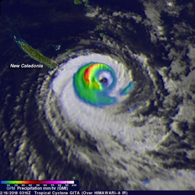
GPM Examines Tropical Cyclone Gita Remnants Over New Zealand

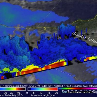
As predicted, the remnants of tropical cyclone GITA hit New Zealand on Tuesday (local time). GITA had transitioned to an extra-tropical low and was much weaker than when it hit Tonga last week. It still contained strong tropical strong force winds with occasionally heavy rainfall. New Zealand's South Island was the hardest hit. The northern end of of the South Island was in the right front quadrant of the tropical cyclone where the wind speeds around the center of circulation were increased by the low's speed of movement. Torrential rainfall led to flooding and landslides on the South Island

Cyclones Gita's Rainfall Measured With GPM's Microwave Imager (GMI)

The GPM core observatory satellite's Microwave Imager (GMI) instrument had a fairly good view of tropical cyclone GITA on February 2018 at 0316 UTC. GPM's Dual Frequency Precipitation Radar (DPR) swath only scanned the area west of GITA's main area of precipitation. The weakening tropical cyclone was passing the southeastern tip of New Caledonia. Although weakening, GITA still had winds estimated at over 90 kts (104 mph). Rainfall derived from GMI data showed that the heaviest precipitation, falling at rate of about 51 mm (2 inches) per hour, was shown west of GITA's low level circulation

Destructive Tropical Cyclone Gita's Rainfall Measured With IMERG

Tropical cyclone GITA recently battered and drenched first Samoa and then Tonga as it passed close to both island groups. GITA was a tropical storm with winds of about 40 kts (46 mph) when it passed to the south of Samoa but still caused widespread destruction and flooding. The president of the United States approved a disaster declaration for Samoa. The tropical cyclone's winds had increased to about 125 kts (144 mph) when it battered Tonga as the equivalent of a category four hurricane on the Saffir-Simpson hurricane wind scale. Destructive winds were the main cause of destruction but heavy

GPM Examines Tropical Cyclone Gita Over Samoa

Recently formed tropical cyclone GITA was drenching Samo when the GPM core observatory satellite passed above on February 9, 2018 at 1426 UTC. Data collected by GPM's Microwave Imager (GMI) and Dual-Frequency Precipitation Radar (DPR) instruments showed the area and intensity of precipitation associated with the tropical cyclone. The area covered by GPM's radar swath is shown in lighter shades. GITA was producing heavy rainfall over a large area that included the islands. The center of the intensifying tropical cyclone was located just to the south of the islands. Rainfall in that area was