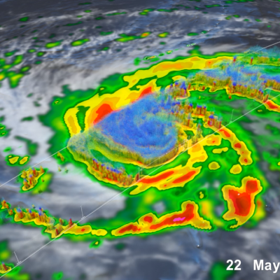
Missions

JAXA DPR Logo
One of the prime instruments onboard the GPM Core Observatory is the Dual-frequency Precipitation Radar (DPR). The DPR consists of a Ku-band precipitation radar (KuPR) and a Ka-band precipitation radar (KaPR). The KuPR, which operates at 13.6 GHz, is an updated version of the highly successful unit flown on the Tropical Rainfall Measuring Mission (TRMM). The KuPR and the KaPR are co-aligned on the GPM spacecraft bus such that the 5-km footprint location on the earth is the same.
GMI in Electromagnetic Interference Testing
The Global Precipitation Measurement (GPM) Microwave Imager (GMI) instrument is a multi-channel, conical- scanning, microwave radiometer serving an essential role in the near-global-coverage and frequent-revisit-time requirements of GPM. The instrumentation enables the Core spacecraft to serve as both a precipitation standard and as a radiometric standard for the other GPM constellation members. The GMI is characterized by thirteen microwave channels ranging in frequency from 10 GHz to 183 GHz. In addition to carrying channels similar to those on the Tropical Rainfall Measuring Mission (TRMM) Microwave Imager (TMI), the GMI carries four high frequency, millimeter-wave, channels near 166 GHz and 183 GHz. With a 1.2 m diameter antenna, the GMI provides significantly improved spatial resolution over TMI.
Thumbnail
The Global Precipitation Measurement (GPM) Core Observatory satellite operates in low Earth orbit, carrying two instruments for measuring Earth's precipitation and serving as a calibration standard for other members of the GPM satellite constellation. The satellite was developed and tested in-house at NASA Goddard Space Flight Center and launched from Tanegashima Space Center, Japan, on February 27th, 2014. The GPM Core Observatory orbits Earth at an inclination of 65 degrees, which enables it to cut across the orbits of other microwave radiometers and sample the latitudes where nearly all precipitation occurs. A non-sun-synchronous orbit that takes it around Earth roughly 16 times per day allows it to sample precipitation at different times of the day. Data is transmitted continuously to ground systems on Earth by the Tracking and Data Relay Satellite (TDRS) communications network.
Thumbnail
Thumbnail
Date: November 12-13th, 2013 Location: NOAA Center for Weather and Climate Prediction University of Maryland M Square Research Park College Park, MD 20740 Remote Meeting Information (WebEx) URL: https://meetings.webex.com/collabs/meetings/join?uuid=M1LOJW7ZTDS0C79V5… Meeting Number: 190 840 131 Audio Connection: Call-in toll number (US/Canada): 1-650-479-3207 Call-in toll-free number (US/Canada): 1-855-244-8681 Access code: 190 840 131 Presentations from yesterday are now available at: http://pmm.nasa.gov/meetings/2013-gpm-applications-workshop/presentatio… Info: The Global
Thumbnail
Overview The GPM Cold-season Precipitation Experiment (GCPEx) was conducted in cooperation with Environment Canada in Ontario, Canada from January 17th to February 29th, 2012. The overarching goal of GCPEx was to characterize the ability of multi-frequency active and passive microwave sensors to detect and estimate falling snow through the collection of microphysical property data, associated remote sensing observations, and coordinated model simulations of falling snow. Through collection of these unique datasets, GCPEx's goal is to improve the GPM snowfall retrieval algorithms. The GCPEx

PPS Announces Limited RETRO-Processing of L1-L3 F16 SSMIS as Version V05B for Apr 2015 through Jan 2018

Starting early the week of March 04, 2019 or shortly after ; PPS will be doing a limited RETRO-processing of Level 1 - Level 3 F16 SSMIS as Version V05B for the period of April 2015 through January 2018. Please see the table below for the specific products and dates affected. If you have previously obtained any of the data listed below, please discard these and replace this data with the retro-processed data as listed. +-------------------------+---------------------+---------------------+----------------+------------+ | DataType | Start of Data | End of Data | ProductVersion | # Granules | +-

Interruption of NOAA Products

Effective around 12:00 UTC 10 June the MHS and ATMS input to real-time IMERG suddenly became unavailable due to an unexpected change in NOAA protocols. While PPS scrambles to remedy the issue, the data content of the Early and Late Runs may be reduced for the next several days, meaning lower Quality Index due to longer morphing of microwave estimates and greater contributions by IR.

MHS NOAA-19 Data Processing Stop (PPS Will Resume NOAA-19 1C and GPROF Data)

PPS will resume to process NOAA-19 MHS L1C and GPROF products for the granules starting from 09/20/2019 10:22:10 UTC. There was an issue with the satellite drifting which caused issues with the pre-processing. NOAA/NESDIS updated the processing coefficient and made the NOAA-19 MHS channel 2 L1B data back to normal.