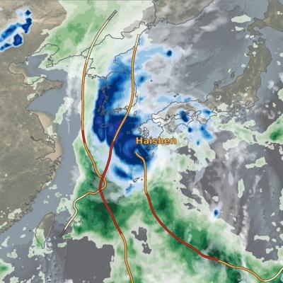
Extreme Weather News

Jump to a Year

2024 | 2023 | 2022 | 2021 | 2020

2019 | 2018 | 2017 | 2016 | 2015

2014 | 2013 | 2012 | 2011 | 2010

2009 | 2008 | 2007 | 2006 | 2005

2004 | 2003 | 2002

IMERG Hurricane Hanna 7-27-20 cropped
Hanna formed from a westward propagating tropical easterly wave that entered the southeast corner of the Gulf of Mexico on Tuesday July 21st. The wave provided a focus for shower and thunderstorm activity, which then led to the formation of an area of low pressure over the central Gulf of Mexico. The National Hurricane Center (NHC) found that this low had developed a closed circulation by the evening of Wednesday July 22nd, making it Tropical Depression #8. Over the next 24 hours, the depression slowly organized and intensified over the central Gulf before reaching tropical storm intensity on
GPM Hurricane Douglas 7-25-20
Hurricane Douglas continued to approach the Hawaiian islands during this GPM overpass early in the morning (02:11 UTC) of July 25, 2020. Douglas had previously strengthened to a Category 4 hurricane the day before, but had substantially weakened over cooler waters throughout the day. Regardless, the GMI and DPR instruments recorded rain rates near 50 millimeters/hour (~2 inches/hour) near Douglas` center. The Central Pacific Hurricane Center advised residents of Hawaii to expect hurricane-strength winds and rainfall starting Saturday evening and lasting through Monday. View fullscreen in STORM
IMERG rainfall totals from Japan, July 3 - 9 2020
From July 3-9, 2020, NASA’s IMERG algorithm continued to observe the heavy precipitation that fell as part of the seasonal Meiyu-Baiu rains (“plum rains”) in east Asia. Weekly totals reached their regional maxima over the island of Kyushu in southern Japan. About half of the island of Kyushu received over 45 cm (~18 inches) of rain. The majority of Honshu, Japan’s main island, as well as Shikoku to its south, were also impacted by the rains, receiving from 10-25 cm, depending on the location. Additionally, large areas of eastern China were also covered by the plum rains during this weekly
IMERG rainfall totals from Japan, June 29 - July 5, 2020
This animation shows NASA IMERG rain rates (blue shading) and accumulations (green shading) near Kyushu island, in the southwest of Japan from June 29 - July 5, 2020. Devastating floods and landslides swept through parts of Kyushu on July 4, 2020, resulting in over 40 deaths and orders for hundreds of thousands of people to evacuate their homes according to media reports. Download video (right-click -> Save As) The rains that triggered the flooding occurred in the context of the Meiyu-Baiu rainy season, which arrives in east Asia every year from June to mid-July. “Meiyu” and “Baiu” are the

GPM IMERG Measures Rainfall from Tropical Storm Cristobal

This animation shows NASA IMERG rain rates (blue shading) and accumulations (green shading) alongside the NOAA low-pressure center track (red line) of Tropical Storm Amanda/Cristobal. The origin of this storm was in the eastern Pacific Ocean in late May 2020, where it was named Tropical Storm Amanda as it approached the southern Mexican and Central American coast. Amanda made landfall in Guatemala on May 31, where it began to deliver the first of a series of heavy rain pulses that led to flooding in the region. After temporarily stalling over land, the system reformed over the Bay of Campeche on June 1 as Tropical Storm Cristobal and made its second landfall on June 3 in Mexico. The storm continued to deliver several pulses of heavy rainfall to southern Mexico, Guatemala, and El Salvador. Some areas of the region accumulated over 60 cm (~2 feet) of rainfall throughout Cristobal's passage. The storm then crossed the Gulf of Mexico and made landfall in Louisiana on June 7 and progressed northward as a tropical depression before being classified as an extratropical low pressure system over Wisconsin on June 10. Large swaths of the U.S. Gulf Coast and Midwest as far north as Wisconsin saw accumulations in excess of 10 cm (~4 inches), and some areas along the coasts of Florida, Alabama, and Mississippi received over 20 cm (~8 inches), during Cristobal’s passage.