Extreme Weather News

Jump to a Year

2024 | 2023 | 2022 | 2021 | 2020

2019 | 2018 | 2017 | 2016 | 2015

2014 | 2013 | 2012 | 2011 | 2010

2009 | 2008 | 2007 | 2006 | 2005

2004 | 2003 | 2002

GPM IMERG Observes Rainfall from Tornado-spawning Storms in the Southern U.S.

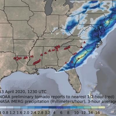
Download video (right-click -> Save As). Credit: Jason West (KBR / NASA GSFC) From Sunday, April 12th, 2020 into Monday the 13th, a series of powerful thunderstorms developed across the southern U.S., bringing heavy rainfall and spawning several destructive tornadoes. This animation shows rainfall estimates for the region for April 11th - 13th derived from NASA's Integrated Multi-satellite Retrievals for GPM (IMERG) data product, along with NOAA tornado reports (red triangles).
GPM Overpass of Cyclone Harold from April 6th, 2020
Video credit: Greg Shirah, Kel Elkins, Alex Kekesi (NASA Goddard Scientific Visualization Studio). For more information or to download this public domain video, go to: https://svs.gsfc.nasa.gov/4812#29226 A Category 4 cyclone, the most powerful yet of 2020, made landfall on the South Pacific nation of Vanuatu on Monday, not long before this GPM overpass from April 6th, 2020 at 1:41 UTC. Tropical Cyclone Harold developed from a low pressure system that was observed to the east of Papua New Guinea last week, and has tracked to the southeast, where it has already caused flooding and loss of life...

GPM Measures Heavy Rainfall from "The Dragon" Cyclonic Storm System in the Middle East

GPM observed the early stages of a strong cyclonic system that developed over northern Africa just off the southern Mediterranean coast on March 11, 2020. The GMI measured heavy rain rates over some parts of Egypt, including the region around Cairo. View fullscreen By March 12, 2020, the cyclonic system that developed over northern Africa had intensified and was nicknamed 'The Dragon' on social media and news outlets, as it caused severe flooding in northern Egypt. Both the GMI and the DPR measured heavy rain rates across two of the storm's bands in this GPM overflight. View fullscreen On

GPM Views Southeast Snowstorm

On February 20th and 21st, 2020, a winter storm brought the seasons largest snowfall to much of North Carolina and southern Virginia. The highest snow totals of 3-5 inches (7-12 cm) were located in northeast NC and southeast VA. GPM's radar captured captured the reflectivities shown in this cross-section as it flew over the snow storm on February 20th, with snow and frozen precipitation shown in blue and purple and rain shown in green and yellow. The melting layer marks the transition from snow to rain and slopes upward 2-3 km from central NC to the coast. These raw reflectivity measurements
Extratropical Storm Dennis, February 15, 2020
Storm Dennis is an extratropical cyclone that developed over the continental United States before undergoing explosive intensification as it crossed into the North Atlantic. On February 15 shortly after this GPM overpass, Dennis reached its minimum central pressure of 920 mb, which is reported to be the second-lowest on record for a North Atlantic winter storm. The eye can be seen south of Iceland, while rain bands to the south caused severe flooding across the British Isles. Text & Visualization by Jason West (NASA / KBR)