
Typhoon Hagibis Brings Heavy Rains to Japan

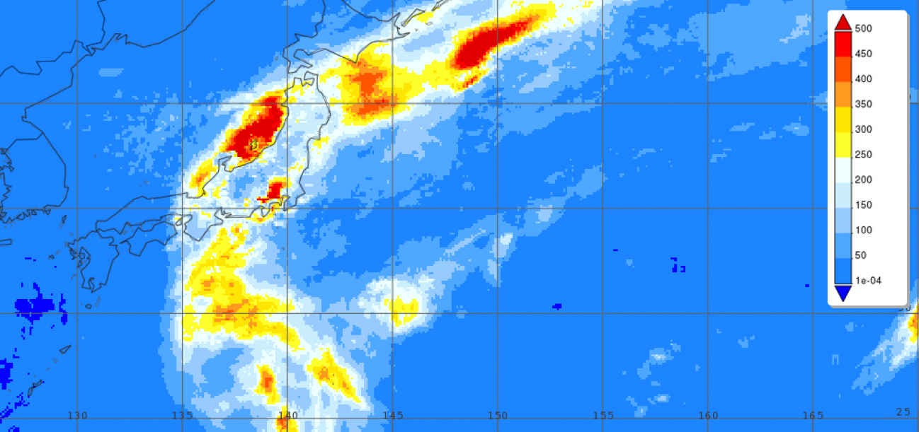
Surface rainfall accumulations (mm) estimated from the NASA IMERG satellite precipitation product from 4 to 13 October 2019 in association with the passage of Typhoon Hagibis. Image from NASA GSFC using IMERG data archived at https://giovanni.gsfc.nasa.gov/giovanni/. This image was produced with the Giovanni online data system, developed and maintained by the NASA GES DISC.
Typhoon Hagibis, a once powerful super typhoon, struck the main Japanese island of Honshu over the weekend, bringing very heavy rains and widespread flooding. Hagibis formed into a tropical storm on the 5th of October from a tropical depression that originated from a westward moving tropical wave north of the Marshall Islands. At first, Hagibis strengthened steadily becoming a typhoon about 24 hours after becoming a tropical storm. But, then on the 7th, Hagibis underwent a remarkable rapid intensification cycle and quickly intensified into a super typhoon with sustained winds estimated at 160 mph by the Joint Typhoon Warning Center (JTWC) less than 24 hours after becoming a minimal typhoon. At this time, Hagibis was bearing down on the Northern Marianas as it continued to move generally westward. On the 8th, Hagibis passed over Anatahan Island in the Marianas about 80 miles north of Saipan. After which, Hagibis underwent an eyewall replacement cycle, which temporarily lowered the storm’s peak intensity. After completing its eyewall replacement cycle, Hagibis regained Category 5 status as it moved through the northern Philippine Sea. At this same time, the cyclone began to re-curve and took on a more northward track towards Japan. As it moved closer towards Japan, Hagibis began to weaken. By 00:00 UTC on the 11th Hagibis was down to a Category 4 storm with sustained winds estimated at 140 mph by JTWC, and by 00:00 UTC on the 12th as the storm neared the coastline of Japan, Hagibis was down to a Category 2 storm with sustained winds of 105 mph. Several hours later, at 8:30 UTC (5:30 pm JST) on the 12th, Hagibis made landfall on the Izu Peninsula southwest of Tokyo as a Category 2 storm. After it made landfall and moved across eastern Honshu, Hagibis merged with a frontal system and became extratropical as it moved back over open water and away from Japan towards the northeast.
Over Japan, the biggest impacts from Hagibis were due to heavy rains and flooding. IMERG, the Integrated Multi-satellitE Retrievals for GPM, is a unified satellite precipitation product produced by NASA to estimate surface precipitation over most of the globe. With IMERG, precipitation estimates from the GPM core satellite are used to calibrate precipitation estimates from microwave and IR sensors on other satellites to produce half-hourly precipitation maps at 0.1o horizontal resolution. Shown here are IMERG surface rainfall accumulations for the period 4 to 13 October 2019 for Japan and the surrounding region from the time when Hagibis first formed until it became extratropical northeast of Honshu. In addition to several areas of heavy rain just off shore, IMERG shows rainfall totals exceeding 400 to 500 mm (~16 to 20 inches, shown in darker orange and red) over east-central Honshu near to where Hagibis made landfall with many areas receiving at least 200 mm (~4 inches, shown in light blue). Locally, over 3 feet of rain was reported in 24 hours southwest of Tokyo. All of this rain caused numerous rivers to overflow their banks as well as several mudslides. So far, Hagibis is being blamed for at least 72 fatalities in Japan.