Typhoons

GPM Overpass of Typhoon Surigae
Although it was only the 2nd named storm of the 2021 Pacific typhoon season, Typhoon Surigae became not only the first super typhoon of the season, but also the strongest tropical cyclone of 2021 worldwide. The majority of storms in the Northwest Pacific region form between June and Nov., but the season runs yearlong, as storms can form in any month in this region, which stretches from 100 degrees East to 180 degrees East, north of the equator. Surigae originated from an area of low pressure about 700 miles south of Guam. Persistent thunderstorm activity resulted in the formation of a tropical
IMERG Comparison of Typhoon Mindulle and Hurricane Sam
From late Sept. through early Oct. 2021, two powerful storms churned over the Pacific and Atlantic Oceans: Typhoon Mindulle, which peaked as a Category 5 storm, and Hurricane Sam, a Category 4 hurricane and one of the longest-lived hurricane-strength storms on record over the Atlantic Ocean. While neither storm posed a direct threat to land, Mindulle brushed by eastern Japan, leaving heavy rainfall accumulations in the area near Tokyo. Despite the fact that neither storm made landfall, the storms’ slow-motion tracks across warm ocean waters allows an opportunity to observe how the strong winds
IMERG Rainfall from Typhoons Bavi, Maysak and Haishen
From August 22 through September 7, 2020, NASA’s IMERG algorithm estimated rainfall from three typhoons as they passed over the Pacific Ocean, Japan, and Korea. According to NOAA's records, this was the only time since records have been kept starting in 1945 that the Korean peninsula saw three landfalling typhoons in a single year, let alone in two weeks. Each of the three typhoons--Bavi, Maysak, and Haishen--reached the equivalent of “major hurricane” status, meaning Category 3 or above on the Saffir-Simpson hurricane-intensity scale (shown here as a red in the hurricane track) along their
Typhoon Hagibis Brings Heavy Rains to Japan
Typhoon Hagibis, a once powerful super typhoon, struck the main Japanese island of Honshu over the weekend, bringing very heavy rains and widespread flooding. Hagibis formed into a tropical storm on the 5th of October from a tropical depression that originated from a westward moving tropical wave north of the Marshall Islands. At first, Hagibis strengthened steadily becoming a typhoon about 24 hours after becoming a tropical storm. But, then on the 7th, Hagibis underwent a remarkable rapid intensification cycle and quickly intensified into a super typhoon with sustained winds estimated at 160 mph by the Joint Typhoon Warning Center (JTWC) less than 24 hours after becoming a minimal typhoon.

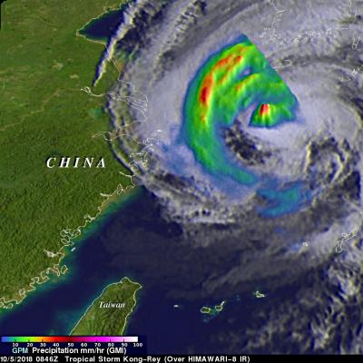
GPM Examines Weaker Tropical Storm Yutu in the South China Sea

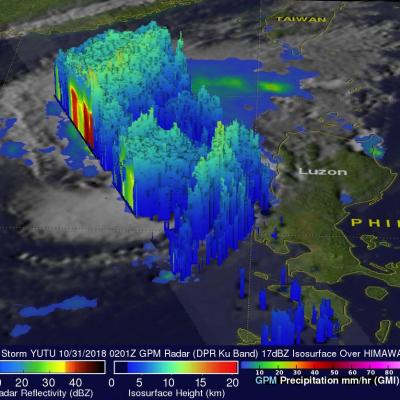
Typhoon YUTU (known as Rosita in the Philippines) is now threatening the Philippine Island of Luzon. On October 24, 2018 YUTU devastated the northern Mariana Islands of Tinian and Saipan as a super typhoon. One death has been attributed to the typhoon in the Marianas with many structures including schools and hospitals being destroyed. Typhoon YUTU weakened as it moved toward the Philippines and had maximum sustained winds of about 90 kts (103.5 mph) when the GPM core observatory satellite passed above the Philippine Sea on October 29, 2018 at 0212 UTC. This rainfall analysis was developed

GPM's GMI Measures Weakening Kong-Rey's Rainfall

The GPM core observatory passed above tropical storm Kong-Rey on October 5, 2018 at 0846 UTC. Kong-Rey was a powerful category five typhoon just a few days ago but increased vertical wind shear and cooler sea surface temperatures have caused the tropical cyclone to weaken dramatically. Tropical storm Kong-Rey had maximum sustained winds of about 55 kts (63 mph) when it was scanned by the satellite. GPM's Microwave Imager (GMI) data were used to gauge the intensity of precipitation around Kong-Rey's center of circulation. Energy observed through clouds by GMI's microwave channels was used to
GPM Views Cat. 2 Typhoon Trami Moving Towards Japan JacobAdmin Wed, 09/26/2018
View fullscreen in STORM Event Viewer Once a Category 5 Super Typhoon, Trami has become rooted in place due to a lack of steering flow. This has caused the storm to deplete the warm waters beneath it and it has since weakened to a Category 2 with maximum winds of 90 knots. It maintains a broad eye and once it begins moving again, is likely to reintensify at least somewhat as it zooms northeastward over the Ryukyu Islands and into the southern coast of Japan. Wind impacts are likely to be exacerbated by its forward speed and current forecasts expect it to have widespread impacts in a region
GPM IMERG Adds Up Heavy Rains from Typhoon Jebi JacobAdmin Wed, 09/05/2018
Typhoon Jebi brought flooding to Japan and NASA’s IMERG estimated rainfall over the country and the surrounding region for a one-week period. The above image shows accumulated IMERG rainfall estimates over Japan and the surrounding region for the 1-week period from August 29 to Sept. 5, 2018 show rainfall amounts on the order of 100 mm (~4 inches, shown in red) or more covering much of the main island of Honshu and Shikoku in the south. Much of the band of rain oriented east-west across central Japan was due to a frontal system that brought rain to the area before Jebi made landfall. Super
GPM Views "Truck-Tire" Eyewall of Typhoon Soulik JacobAdmin Tue, 08/21/2018
View Fullscreen in STORM Event Viewer Avoiding Kyushu, Typhoon Soulik instead barrelled toward the Northern Ryukyu islands, with the 'truck-tire' eyewall impacting Amami (in the south) and Yakushima (in the north) Islands in this overflight. It featured winds approaching 100 knots as it moved northwestward. Soulik is expected to recurve toward the western coast of Korea, where it is likely to have devastating impacts to the majority of the peninsula depending on its ability to maintain intensity.

GPM Flies Over Typhoon Jongdari Twice in Two Days

7/27/18 Having both deepened in central pressure and broadened in precipitation shield, Jongdari is steadily intensifying as it churns towards the southern coast of Japan. In this overflight, the storm has deep convection both near the eye itself and scattered throughout its outer bands, and its maximum sustained winds are approaching 90 knots. It is expected to further intensify over the next 24 hours, reaching Category 3 status before weakening slightly prior to making landfall south of Nagoya. Jongdari will bring heavy rains and strong winds to a heavily-populated region, including the