IMERG

IMERG Precipitation Totals from Eastern Australia, March 16 - 23, 2021
During the week ending on March 23, 2021, two locations in Australia experienced unusually high rainfall totals. According to news reports a persistent system brought flooding rains to Australia's east coast from Brisbane to Sydney and points further south. The preliminary estimate from NASA's multi-satellite global precipitation analysis is that more than 24 inches fell just off the coast of Australia in 7 days with accumulations in coastal areas exceeding 16 inches. Near the Strzelecki Desert in central Australia, a storm system brought 8 inches of precipitation during the same 7-day period. Most of the rain fell during a 3-day period (0000 UTC on 20 March to 2359 UTC on 22 March).
Hurricane Eta IMERG Screenshot
The extremely active 2020 Atlantic hurricane season, aided by the ongoing La Niña, continues on. After Hurricane Zeta made landfall along the northern part of the Gulf Coast, yet another hurricane has arisen - Hurricane Eta, the strongest of the season. Like Zeta, Eta also formed in the Caribbean, where sea surface temperatures are still running quite warm at around 29° C, almost a full degree above average and well above the typical 26° C needed for tropical cyclone development. But while Zeta turned north into the Gulf of Mexico, Eta moved westward where it delivered powerful winds and

GPM IMERG Observes Rainfall from Tornado-spawning Storms in the Southern U.S.

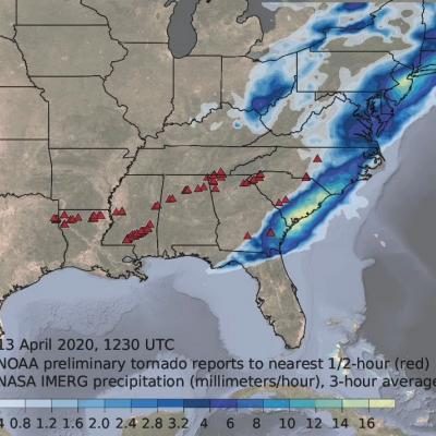
Download video (right-click -> Save As). Credit: Jason West (KBR / NASA GSFC) From Sunday, April 12th, 2020 into Monday the 13th, a series of powerful thunderstorms developed across the southern U.S., bringing heavy rainfall and spawning several destructive tornadoes. This animation shows rainfall estimates for the region for April 11th - 13th derived from NASA's Integrated Multi-satellite Retrievals for GPM (IMERG) data product, along with NOAA tornado reports (red triangles).
IMERG Grand Average Climatology 2001 - 2019
IMERG rainfall totals from Australia in November 2019
Droughts and dry, arid conditions are naturally occurring phenomena in Australia. Such an environment is conducive to wild fires, which are started mainly by lightning and can occur throughout the year, but typically emerge between October and April and are most prevalent during the Southern Hemisphere summer; they are part of the seasonal cycle in Australia. However, some years are worse than others, and the 2019-2020 wild fire season was especially bad. It has been estimated that upwards of 46 million acres were burned, or roughly the size of the entire state of Washington. In terms of area...
Rain Brought Brief Relief to Australia
For much of the 2019-2020 austral summer, plumes of bushfire smoke have billowed from southeastern Australia in such large amounts that the ground was barely visible in satellite images. In mid-January, some of those plumes were finally quelled by a few days of much-needed rainfall.

TRMM era IMERG Completed & End of FTP at PPS

IMERG is now available back to June 2000 of the TRMM era. Both the 'early' and the 'late' products have been retrospectively processed. These products are available in the same location on the jsimpson.pps.eosdis.nasa.gov FTP server as the current GPM IMERG products: /NRTPUB/imerg/early/YYYYMM and /NRTPUB/imerg/late/YYYYMM. We are in the process of retrospectively processing the GIS-friendly versions and accumulations of these IMERG products. This is likely to be completed by the end of September 2019. **IMPORTANT** A very important item is that we have been directed to eliminate ftp to all

Early and Late IMERG IR Issues

Difficulties with accessing NOAA CPC 4-km Merged Global IR data resulted in the loss of IR data in IMERG Early Run for 12 November 12:00-21:30 UTC and 14 November 10:00-15 November 10:30 UTC, and in IMERG Late Run for 12 November 12:00-20:30 UTC and 14 November 10:00-15 November 09:30 UTC. Subsequently, the IR data were retrieved for use in the Final Run.
IMERG Sees a Dry September
Rainfall was scarce across much of the country in the month of September, pushing the eastern and southern thirds of the country into drought conditions. IMERG, the Integrated Multi-satellitE Retrievals for GPM, is a unified satellite precipitation product produced by NASA to estimate surface precipitation over most of the globe.
20 Years of IMERG - Resources
NASA Announces Long-term IMERG Satellite Record: A Near-Global 19-year Perspective on Rain and Snow NASA has just released its newest estimate of rain and snow covering the past 19 years. It's code name: Version 6 IMERG. NASA's IMERG -- the Integrated Multi-satellitE Retrievals for GPM -- combines information from whatever constellation of satellites are operating in Earth orbit at a given time, to estimate precipitation over the majority of the Earth's surface. This algorithm is particularly valuable over the majority of the Earth's surface that lacks precipitation-measuring instruments on...