IMERG

Typhoon Hagibis Brings Heavy Rains to Japan
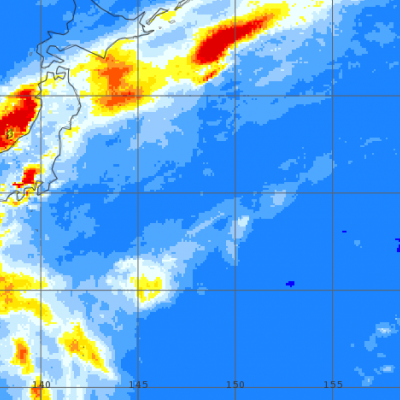
Typhoon Hagibis, a once powerful super typhoon, struck the main Japanese island of Honshu over the weekend, bringing very heavy rains and widespread flooding. Hagibis formed into a tropical storm on the 5th of October from a tropical depression that originated from a westward moving tropical wave north of the Marshall Islands. At first, Hagibis strengthened steadily becoming a typhoon about 24 hours after becoming a tropical storm. But, then on the 7th, Hagibis underwent a remarkable rapid intensification cycle and quickly intensified into a super typhoon with sustained winds estimated at 160 mph by the Joint Typhoon Warning Center (JTWC) less than 24 hours after becoming a minimal typhoon.
Two Decades of Precipitation Measurement
NASA’s Precipitation Measurement Missions (PMM) have collected rain and snowfall from space for nearly 20 years, and for the first time in 2019, scientists can access PMM’s entire record as one data set. PMM includes two missions – the Tropical Rainfall Measuring Mission (TRMM), which orbited Earth from 1997 to 2015, and its successor, the joint NASA-JAXA Global Precipitation Measurement mission (GPM), which has been collecting data since 2014. This year, however, the GPM project upgraded its data algorithms to calibrate and incorporate TRMM data into its release, giving researchers, modelers...
Hurricane Dorian Brings Heavy Rain to Bahamas
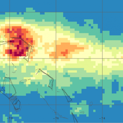
In addition to the powerful winds that have raked the northern Bahamas over the past few days, Hurricane Dorian’s slow motion has brought very heavy rainfall to the islands as well. Dorian first formed into a tropical depression on the 24th of August about 800 miles east southeast of Barbados in the Lesser Antilles from an area of low pressure; the depression was quickly upgraded to a minimal tropical storm and named Dorian by the National Hurricane Center (NHC) later in the day. As Dorian made its way westward under the influence of a high pressure ridge to the north, it was held in check...
IMERG Measures Rainfall in Hurricane Dorian
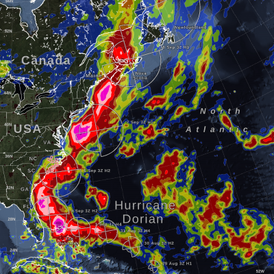
UPDATE 9/9/19: On Monday morning, September 9, Hurricane Dorian was a post-tropical storm after a mid-latitude weather front and cold seas had altered its tropical characteristics over the weekend. On Saturday and Sunday, Hurricane Dorian struck eastern Canada, causing wind damage and bringing heavy rainfall. According to the Associated Press, a peak of 400,000 people were without power in Nova Scotia, Canada, because of Dorian. This graphic shows precipitation that fell during the almost two-week period from August 27 to the early hours of September 9. The near-realtime rain estimates come...
Observing the Intertropical Convergence Zone with IMERG
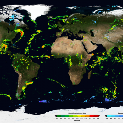
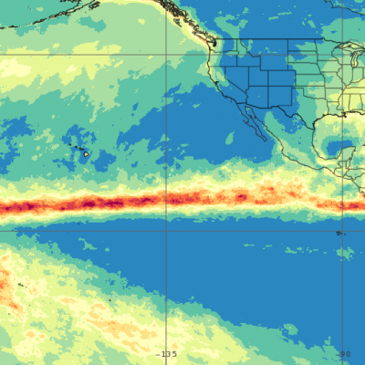
The intertropical convergence zone or “ITCZ” roughly forms a band that circumnavigates the Earth near the Equator where the northeast trade winds in the Northern Hemisphere converge with the southeast trade winds in the Southern Hemisphere. Sailors have often referred to it as the “doldrums” due to its generally light winds. Yet, the ITCZ is an important part of the global circulation as it forms the ascending branch of the Hadley circulation. This is ultimately driven by incoming solar radiation, which peaks near the Equator. This warms the air and the ocean, causing warm buoyant air to rise...

GPM IMERG Measures Hurricane Michaels Rainfall Accumulation

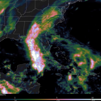
At least eleven deaths have now been attributed to deadly hurricane Micheal. Some casualties resulted not only from Micheal's destructive winds and storm surges but also from the blinding rain that Micheal produced as it battered states from Florida northeastward through Virginia. Today tropical storm Micheal is moving out over the Atlantic Ocean and has transitioned into a powerful extratropical storm. This animation using the GPM IMERG multi-satellite dataset shows the estimated total rainfall accumulation for #HurricaneMichael from 10/8/18 - 10/12/18. Learn more: https://t.co/aJuEp6o855 pic

IMERG Measures Flooding Rainfall In Deadly California Wildfire Areas

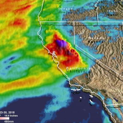
Heavy precipitation has been falling in areas of California that were recently devastated by deadly wildfires. This flooding rainfall has resulted in evacuations in burn scarred areas such as Butte County where the deadly Camp Fire hit this month. Flash floods, debris flows and mudslides are now predicted in areas where deadly wildfires stripped away vegetation. On a positive note these Pacific storms are expected to dampen wildfires and replenish the Sierra Nevada snowpack. This snowpack is an important source of water for California's streams and rivers. NASA's Integrated Multi-satellitE

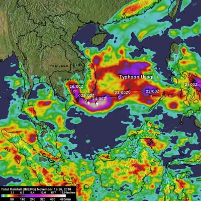
NASA's IMERG Used To Analyze Tropical Storm Usagi's Rainfall

Usagi strengthened to hurricane intensity as it approached Vietnam from the South China Sea but weakened to tropical storm intensity when coming ashore. Very heavy rainfall and damaging winds accompanied tropical storm Usagi when it hit Vietnam's southern coast. More than 350 mm (14 inches) of rainfall was reported causing widespread flooding around Ho Chi Minh City. NASA's Integrated Multi-satellitE Retrievals for GPM (IMERG) data were used to show estimates of rainfall accumulation produced by Usagi as the tropical cyclone moved across the South China Sea into Southeast Asia. This IMERG

Italy's Extreme Rainfall Examined With IMERG

During the past week a strong low-pressure system moving through southern Europe battered, drenched and flooded Italy. It caused flooding, landslides and other damage to large areas of the country. The deaths of at least 11 people have been attributed to this stormy weather. High winds knocked down many trees and heavy rainfall from these storms contributed to flooding in large areas of Italy. Venice was inundated when heavy rain fell and a surge of water from the Adriatic Sea was pushed into the city by the storm's very high winds. Data from various satellites, that cover most of the globe

GPM IMERG Adds Up Heavy Rainfall from Typhoon Mangkhut

#NASA 's GPM IMERG data product was used to estimate the devastating heavy rainfall that fell on China and the Philippines from #TyphoonMangkhut . This video shows storm-total and 3-hourly precipitation accumulations from 9/11/17 - 9/17/18. Learn more: https://t.co/8PzhK9pCDW pic.twitter.com/x6gf6N8VWH — NASA Precipitation (@NASARain) September 18, 2018 In the past week, Typhoon Mangkhut has affected the Philippines, mainland China, and Hong Kong, as shown in this 7-day animation of NASA's satellite-based IMERG precipitation product. The upper frame shows the storm-total accumulation starting