Articles

IMERG Rainfall Total from Week of Jan 25 2021
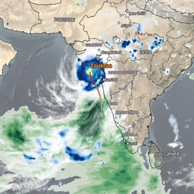
NASA combined data from multiple satellites to estimate the rainfall from an "atmospheric river" event over the U.S. West Coast in near real-time at half-hourly intervals from January 25 - 29, 2021. Atmospheric rivers are long, narrow corridors of water vapor that can lead to heavy precipitation when they encounter land. This animation shows estimated rainfall rates in blue and yellow shading and total rainfall accumulations in green shading, from NASA's IMERG algorithm, overlaid on shades of white and gray from NOAA infrared satellite data which shows cloudiness. On January 25, 2021, a low
IMERG Total from Cyclone Gati
On November 22, 2020, Cyclone Gati became the strongest storm to hit Somalia since satellite records began five decades ago. Gati made landfall with maximum sustained winds of 170 kilometers (105 miles) per hour, a category 2 storm on the Saffir-Simpson scale. The storm brought more than a year’s worth of rain to the region in two days. Local authorities report at least eight people were killed and thousands have been displaced. The map above shows rainfall accumulation from November 21-23, 2020. These data are remotely-sensed estimates that come from the Integrated Multi-Satellite Retrievals
IMERG Rainfall Totals from Eta & Iota, November 1 - 18
The record-breaking 2020 Atlantic hurricane season, aided by the ongoing La Niña, is officially the most active Atlantic hurricane season on record, surpassing the 2005 season in the total number of named storms with 30 to date. Incredibly, the latest storm Iota wasn’t just another named storm, but a powerful Category 5 hurricane and the strongest storm of the season. It was also only the 2 nd Category 5 storm to occur in the month of November on record, the other being in 1932. The warm waters of the Caribbean continue to serve as a breeding ground for late-season storms this season. Iota
Landslide Risk in Central America
On November 3, 2020, Hurricane Eta made landfall as one of the most powerful hurricanes to hit Central America in years. The category 4 storm destroyed hundreds of homes, killed more than 100 people, and brought torrential rains that triggered large and numerous landslides in Guatemala and Honduras. Less than two weeks later, Hurricane Iota—an even more powerful category 4 storm—nearly retraced Eta’s path. Within hours of Eta’s landfall and flooding rains, researchers at NASA’s Goddard Space Flight Center worked to predict landslides and map the storm’s aftermath. One team assessed potential
GPM Overpass of Hurricane Eta Nov. 11 2020
After a long and meandering journey over Central America, across central Cuba, and through the Florida Keys, Eta, the 28th named storm and 12th hurricane of the 2020 Atlantic hurricane season, wound up nearly stationary as a moderate tropical storm in the southeastern Gulf of Mexico just north of the western tip of Cuba on the morning of November 10th. Before long however, a deep layer trough located over the western third of the US began to shift eastward, and by the afternoon of the 10th, it started to pull Eta back towards the north and the west coast of the Florida peninsula. As it did so