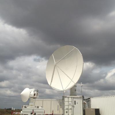
Articles

TRMM image of hurricane Irene intesifying as it nears the Bahamas
UPDATE: Monday, August 29th, 2011 Irene Drenches Northeastern United States UPDATE: Friday, August 26th, 2011 Irene Passes Through the Bahamas, Heads Towards Cape Hatterus Wednesday, August 24th, 2011 After becoming a small hurricane while passing over Puerto Rico, Irene re-emerged over the warm, open waters of the western Atlantic northwest of the Dominican Republic on the morning of August 22nd. The storm quickly showed signs of intensifying as deep convective towers arose near the center of Irene, releasing heat into the core of the system. In response, Irene's central pressure fell and...
GPM flying over Earth with a data swath visualized.
A key component of the TRMM project is the Ground Validation (GV) effort which consists of collecting data from ground-based radar, rain gauges and disdrometers. The data is quality-controlled, and then validation products are produced for comparison with TRMM satellite products. The four primary GV sites are Darwin, Australia; Houston, Texas; Kwajalein, Republic of the Marshall Islands; and, Melbourne, Florida. A significant effort is also being supported at NASA Wallops Flight Facility (WFF) and vicinity to provide high quality, long-term measurements of rain rates (via a network of rain...
GPM flying over Earth with a data swath visualized.
Precipitation Measurement Mission Science NASA’s Precipitation Measurement Missions (PMM) develop and deploy advanced space-borne sensors to gain physical insights into precipitation processes and to enable improved monitoring and forecasting of climate, weather and precipitation-related natural hazards. PMM includes the Tropical Rainfall Measuring Mission (TRMM) and the Global Precipitation Measurement (GPM) mission. TRMM and GPM pursue a unique and innovative approach to measuring precipitation from space through the collection of observations by both active and passive sensors , which are...
GPM flying over Earth with a data swath visualized.
The NASA NPOL radar is a research grade S-band, scanning dual-polarimetric radar. The NPOL underwent a complete antenna system upgrade in 2010 and is one of two fully transportable research-grade S-band systems in the world. It is used to make accurate volumetric measurements of precipitation including rainfall rate, particle size distributions, water contents and precipitation type. Click here to view the latest NPOL data from the GPM Precipitation Science Research Facility at Wallops Flight Facility. Examples of NPOL-Generated Images
The NPOL instrument, a large radar dish attached to a trailer under a blue sky
To gain a better understanding of precipitation processes and to assess and refine the physical assumptions that go into the GPM algorithms, the ground validation team makes field measurements of specific parameters that describe the physical characteristics and variability of rainfall, including rainfall intensity, distribution, particle shape and precipitation type. Ground validation uses specific ground instrumentation infrastructure developed to observe, quantify and document the physical properties of precipitation. These instruments include: The NASA NPOL radar A research grade S-band...