TRMM News

Typhoon Bopha Threatens Philippines

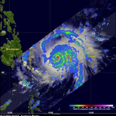
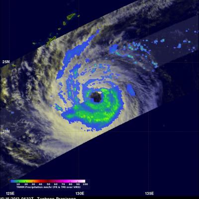
At 0347 UTC today the TRMM satellite flew above a dangerous typhoon in the western Pacific Ocean called Bopha that is a threat to the Philippines. Bopha is predicted by the Joint Typhoon Warning Center (JTWC) to hit the island of Mindinao in the Philippines with winds of 135 kts (155 mph) later today. The first image shows a satellite view of typhoon Bofa with rainfall from TRMM's Microwave Imager (TMI) and Precipitation Radar (PR) instruments overlaid on a visible/infrared image from TRMM's Visible and InfraRed Scanner (VIRS). This analysis shows that Bopha had a well defined eye with very

TRMM Sees Tornado Spawning Thunderstorms

In the United States tornadoes develop most often in the spring when warm moist unstable air accompanies strong fronts and fluctuating upper-air systems. There is a also a slight increase in tornado activity in late October and November. Tornadoes form least often in December and January so the tornadoes that occurred yesterday over the south-eastern United States were unusual. The TRMM satellite was flying over on December 10, 2012 at 1743 UTC (12:43 PM EST) and captured data showing tornado spawning thunderstorms within a frontal system moving through Louisiana, Mississippi, Alabama, Georgia

2012 Western Atlantic Tropical Cyclone Rainfall Measured From Space

The TRMM satellite has now been making highly accurate measurements of rainfall from space for fifteen years. TRMM can be used to calibrate rainfall estimates from other additional satellites. Those Rainfall data (3B42) are routinely created and stored at the Goddard Space Flight Center. The TRMM-based, near-real time Multi-satellite Precipitation Analysis (TMPA) at the NASA Goddard Space Flight Center can be used to analyze rainfall over a wide portion of the globe. The TMPA analysis above shows the estimated amount of rain contributed by named tropical cyclones over the western Atlantic in

TRMM Sees Tropical Storm Bofa

The TRMM satellite flew above tropical storm Bofa on November 27, 2012 at 1601 UTC and collected data used in the image above. TRMM showed that tropical storm Bofa had an area of very intense convective storms near the center of circulation. TRMM's Microwave Imager (TMI) and Precipitation Radar (PR) data revealed that rain was falling at a rate of over 70mm/hr (~1.75 inches) in that area. TRMM's Precipitation Radar (PR) also showed that powerful storms in the area of the developing eye wall were reaching to heights of about 17km (~10.6 miles). Click here to see a simulated flyby above Bofa

Heavy Rain Brings Flooding to Central and Northern Italy

Beginning this past weekend, parts of central and northern Italy received several days of heavy rain as an upper-level trough situated over western Europe down through the Iberian Peninsula in conjunction with a persistent area of low pressure at the surface over the northern coast of Africa brought a steady flow of warm, moist, unstable air northeastward across the country from the western Mediterranean. A stationary frontal boundary draped across the northern third of the Italian Peninsula provided the focus for showers and storms in that part of the country. The rains caused flooding in

Typhoon Jewalat Batters Japan

The TRMM satellite had an excellent look at typhoon Jelawat on September 29, 2012 at 1944 UTC. Jelawat had already battered Okinawa with 75kt (~87mph) winds and was headed for the main islands of Japan. An analysis of rainfall from TRMM's Microwave Imager (TMI) and Precipitation Radar (PR) instruments is shown overlaid on an enhanced infrared image from TRMM's Visible and InfraRed Scanner (VIRS). Rain is shown falling at a rate of over 90mm/hr (~3.5 inches) in strong feeder bands northwest of Jelawat's center of circulation. Jelawat was already causing light to moderate rainfall on the

Tropical Cyclone Anais (01S) Intensifying

The first tropical cyclone of the 2012 South-West Indian Ocean season called Anais formed northeast of Madagascar yesterday. The TRMM satellite saw Anais on October 13, 2012 at 0805 UTC (~12:05 PM Local). TRMM's Microwave Imager (TMI) and Precipitation Radar (PR) rainfall are shown on the right. Intense bands of rain are shown spiraling around the southern side of the intensifying tropical cyclone. TRMM's Precipitation Radar (PR) data were used to make the 3-D perspective image above. It shows that Anais' had a developing eye wall containing towering thunderstorms reaching an altitude of 15km

Tropical Cyclones In Three Oceans

The TRMM satellite saw tropical cyclones in three ocean basins today. TRMM flew nearly above tropical storm Patty in the Atlantic Ocean northwest of the Bahamas first on October 12, 2012 at 0326 UTC. It was night so an enhanced infrared image from TRMM's Visible and InfraRed Scanner (VIRS) was overlaid with a rainfall analysis derived from TRMM's Microwave Imager (TMI) and Precipitation Radar (PR) instruments. Patty's location, close to the edge of the TMI swath, is shown with a red tropical storm symbol. TRMM also viewed a developing tropical cyclone in the South-West Indian Ocean on October

Weakening Typhoon Prapiroon

The TRMM satellite again flew above typhoon Prapiroon in the western Pacific Ocean on October 15, 2012 at 0632 UTC. Prapiroon's sustained wind speeds had dropped to 70 kts (~81 mph) with a large and ragged eye being it's dominant feature. TRMM's Microwave Imager (TMI) data indicated that the most intense rain bands south of Prapiroon's eye were dropping rain at a rate of about 30-40 mm/hr (~1.2 to 1.6 inches).

TRMM Sees Prapiroon Near Japan

The TRMM satellite recently had good views of tropical storm Prapiroon when it was passing east of Japan. The TRMM satellite captured data on October 18, 2012 at 0845UTC and again at 1019 UTC. TRMM's Microwave Imager (TMI) and Precipitation Radar (PR) data show that rain associated with Prapiroon was falling at a rate of over 75mm/hr (~3 inches) in a feeder band northwest of the center of circulation. TRMM PR found radar reflectivity values above 50.770 dBz in that area. Some of the rainfall over Japan was being caused by a frontal system that was interacting with tropical storm Prapiroon