TRMM News

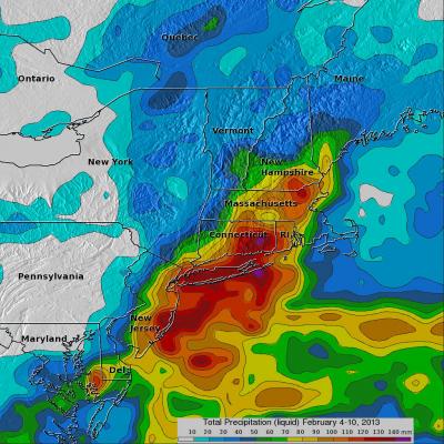
TRMM Sees Intensifying Winter Storm

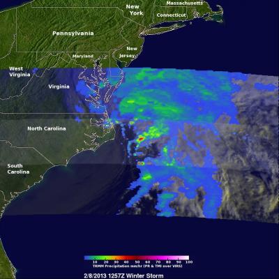
At 1257 UTC (7:57 AM EST) this morning the TRMM satellite passed above a rapidly deepening low pressure center over coastal North Carolina. TRMM already saw stormy weather with this low when it was forming yesterday along the Gulf coast. Another area of low pressure moving from the Mid-West is predicted to merge with this storm and result in extreme blizzard conditions over the North-East. Near hurricane force winds and snowfall depths of over 610mm (~24 inches) are predicted in some areas from New York to Boston. An analysis of rainfall from TRMM's Microwave Imager (TMI) and Precipitation

2013 New England Blizzard

As accurately predicted by the National Weather Service, a blizzard dropped extreme amounts of snow over the North-East beginning on February 8, 2013. An amazing snow depth of 38 inches (~965 mm) was reported in Milford, Connecticut. The blizzard was reportedly the cause of at least 14 deaths in the United States and Canada. The TRMM-based, near-real time Multi-satellite Precipitation Analysis (TMPA) at the NASA Goddard Space Flight Center is used to estimate precipitation for much of the globe. TMPA (liquid) precipitation totals (mm) are shown for the week from February 4-10 when the blizzard

Tropical Storm Haruna Headed For Madagascar

The TRMM satellite had a good look at a tropical storm called Haruna forming in the Mozambique Channel on February 18, 2013 at 1541 UTC. Haruna was called a tropical storm early today and TRMM had another fairly good view when it flew above at 0811 UTC. Haruna is predicted to intensify to a strong tropical storm with wind speeds of about 50kts (~58 mph) and cross southern Madagascar in a couple days. TRMM's Microwave Imager (TMI) and Precipitation Radar (PR) rainfall data were used in the two rainfall analyses shown. TRMM PR showed that very intense rain was falling at a rate of over 134 mm/hr

Tropical Storm Haruna Intensifying

The TRMM satellite flew above intensifying tropical storm Haruna in the Mozambique Channel again on February 20, 2013 at 0717 UTC. A rainfall analysis using data from TRMM's Microwave Imager (TMI) and Precipitation Radar (PR) instruments is shown overlaid on a combination visible/infrared image from the Visible and InfraRed Scanner (VIRS). TRMM showed that Haruna had become much better organized than yesterday with intense bands of rainfall circling the tropical cyclone's center of circulation. Some rain in powerful storms on the northern edge of Haruna's center was found by TRMM PR to be

Deadly Tropical Cyclone Haruna Departs Madagascar

Tropical cyclone Haruna has battered southwestern Madagascar with hurricane force winds and flooding rainfall for the past two days. The city of Morombe was heavily damaged and Haruna was reported to have killed six people. The TRMM satellite passed over Haruna yesterday on February 22, 2013 at 1336 UTC when the tropical cyclone was over southwestern Madagascar. TRMM passed almost directly above weakening tropical storm Haruna again today on February 23, 2013 at 0608 UTC. Haruna weakened from category one hurricane force yesterday to tropical storm force today. Today TRMM's Microwave Imager

Tropical Cyclone Rusty Heading For Australia

A tropical cyclone called Rusty developed in the Indian Ocean north of north-western Australia's coast on February 24, 2013. The TRMM satellite viewed the intensifying tropical cyclone when it flew over on February 25, 2013 at 0750 UTC. A rainfall analysis from TRMM's Microwave Imager (TMI) and Precipitation Radar (PR) with that orbit is shown overlaid on a visible/infrared image from TRMM's Visible and InfraRed Scanner (VIRS). This analysis showed that Rusty had an extensive area of rainfall surrounding Rusty's very large eye. TRMM PR and TMI instruments found that rain within wide bands of

Powerful Rusty At Australia's Door

Tropical cyclone Rusty's winds had increased to hurricane intensity when the TRMM satellite flew directly above on February 26, 2013 at 0654 UTC. A rainfall analysis derived from TRMM data is shown with the first image. Rain rates in the center of the swath are from the TRMM PR, while those in the outer swath are from the TRMM Microwave Imager (TMI). The rain rates are overlaid on a combination infrared (IR) visible (vis) image derived from the TRMM Visible Infrared Scanner (VIRS). TRMM PR found that the heaviest surface rain was coming down at a rate of over 138mm/hr (~5.4 inches). This

Intensifying Tropical Cyclone Moving Over Samoan Islands

The TRMM satellite passed above an intensifying tropical cyclone in the South Pacific Ocean called Evan on December 11, 2012 at 1759 UTC. Evan is predicted to attain hurricane force winds on December 13, 2012 when it is moving through the Samoan Islands. An analysis of Evan's rainfall from TRMM's Precipitation Radar (PR) and Microwave Imager (TMI) shows that Evan already had an eye-like structure at the time of this TRMM orbit. Click here To a simulated flyby courtesy of TRMM Precipitation Radar (PR) data. TRMM's 3-D Precipitation Radar (PR) data were used to measure the heights of Evan's

Typhoon Bopha's Heavy Rain Over Mindanao

High winds, flooding and landslides from heavy rains with typhoon Bopha have caused over 300 deaths in the southern Philippines. The Tropical Rainfall Measuring Mission (TRMM) satellite's primary mission is the of measurement of rainfall in the Tropics. The TRMM-based, near-real time Multi-satellite Precipitation Analysis (MPA) at the NASA Goddard Space Flight Center monitors rainfall over the global Tropics. MPA rainfall totals are shown here for the period from November 28 to December 5, 2012 when typhoon Bopha was moving through the southern Philippines. Typhoon Bopha's track is shown

Typhoon Bopha Devastates Mindanao, Moves Into Sulu Sea

Typhoon Bopha pounded the Philippines with high winds and drenching rain when it crossed the island of Mindanao today. Numerous deaths and wide spread destruction have been reported. The TRMM satellite had a good view of Bopha moving into the Sulu Sea when it flew over on December 4, 2012 at 1420 UTC. This TRMM pass showed that Bopha still had good organization but Mindanao's rugged terrain had taken it's toll. Bopha's eye had been disrupted but TRMM Precipitation Radar (PR) data revealed that very heavy rain was still falling at a rate of over 85 mm/hr (~3.5 inches) near the center of the